


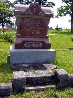
Elizabeth Dekalb Fett
| Birth | : | 9 Sep 1854 |
| Death | : | 11 May 1929 |
| Burial | : | Our Lady and St. Nicholas Churchyard, Wanlip, Charnwood Borough, England |
| Coordinate | : | 52.6910000, -1.1150000 |
frequently asked questions (FAQ):
-
Where is Elizabeth Dekalb Fett's memorial?
Elizabeth Dekalb Fett's memorial is located at: Our Lady and St. Nicholas Churchyard, Wanlip, Charnwood Borough, England.
-
When did Elizabeth Dekalb Fett death?
Elizabeth Dekalb Fett death on 11 May 1929 in
-
Where are the coordinates of the Elizabeth Dekalb Fett's memorial?
Latitude: 52.6910000
Longitude: -1.1150000
Family Members:
Spouse
Children
Flowers:


Nearby Cemetories:
1. Thurmaston Parish Church Leicestershire
Leicester Unitary Authority, England
Coordinate: 52.6785900, -1.0993062
2. St Michael and All Angels Churchyard
Thurmaston, Charnwood Borough, England
Coordinate: 52.6785630, -1.0989530
3. Greengate Lane Cemetery
Birstall, Charnwood Borough, England
Coordinate: 52.6800110, -1.1346940
4. St James the Great Churchyard
Birstall, Charnwood Borough, England
Coordinate: 52.6741150, -1.1189210
5. Thurmaston Cemetery
Thurmaston, Charnwood Borough, England
Coordinate: 52.6788150, -1.0948670
6. St. Mary and St. John Churchyard
Rothley, Charnwood Borough, England
Coordinate: 52.7083290, -1.1340270
7. Chapel of the Knights Templar
Rothley, Charnwood Borough, England
Coordinate: 52.7056000, -1.1478000
8. Saint Peter & Saint Paul's Churchyard
Syston, Charnwood Borough, England
Coordinate: 52.7007410, -1.0746400
9. All Saints Churchyard
Cossington, Charnwood Borough, England
Coordinate: 52.7173590, -1.1073300
10. Belgrave Cemetery
Belgrave, Leicester Unitary Authority, England
Coordinate: 52.6653570, -1.1311220
11. Rothley Cemetery
Rothley, Charnwood Borough, England
Coordinate: 52.7162850, -1.1367740
12. Syston Cemetery
Syston, Charnwood Borough, England
Coordinate: 52.6951100, -1.0675000
13. All Saints Churchyard
Thurcaston, Charnwood Borough, England
Coordinate: 52.6906870, -1.1647320
14. St. Peter's Churchyard
Belgrave, Leicester Unitary Authority, England
Coordinate: 52.6594208, -1.1255690
15. Barkby Cemetery
Barkby, Charnwood Borough, England
Coordinate: 52.6840800, -1.0602200
16. St Mary's Church
Barkby, Charnwood Borough, England
Coordinate: 52.6825100, -1.0599100
17. Christchurch Churchyard
Mountsorrel, Charnwood Borough, England
Coordinate: 52.7268480, -1.1409340
18. St. Mary's Churchyard
Sileby, Charnwood Borough, England
Coordinate: 52.7308600, -1.1121420
19. Sileby Cemetery
Sileby, Charnwood Borough, England
Coordinate: 52.7299340, -1.1004210
20. St. Peter's Churchyard
Mountsorrel, Charnwood Borough, England
Coordinate: 52.7304450, -1.1408620
21. St. Leonard's Churchyard
Swithland, Charnwood Borough, England
Coordinate: 52.7103000, -1.1800300
22. Leicester Abbey
Leicester, Leicester Unitary Authority, England
Coordinate: 52.6489600, -1.1369470
23. St Botolphs Churchyard
Ratcliffe on the Wreake, Charnwood Borough, England
Coordinate: 52.7248680, -1.0680400
24. Ratcliffe College
Ratcliffe on the Wreake, Charnwood Borough, England
Coordinate: 52.7294430, -1.0758320