
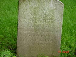
Elizabeth Freeman Trowbridge
| Birth | : | 18 May 1775 Succasunna, Morris County, New Jersey, USA |
| Death | : | 25 Apr 1845 Morris Plains, Morris County, New Jersey, USA |
| Burial | : | St. Mary the Virgin Churchyard, Gisburn, Ribble Valley Borough, England |
| Coordinate | : | 53.9356080, -2.2605210 |
| Description | : | Wife of Augustine Bayles Trowbridge, mother of Shubael, Stephen, Mary, Joanna, John Ross, Lydia, David, Elijah Freeman, Elizabeth, and Jane Lewis Trowbridge. Her obituary appeared in the Morristown Jerseyman newspaper on May 28, 1845: "On the 28th ult. on Trowbridge, wife of Mr. Augustin Trowbridge. Mrs. T's death was very sudden and unexpected. In the afternoon she was in this town, apparently in her usual good health. Soon after she came home he left the house, but returned in a very few minutes, found her in a chair, in the agonies of death. He laid her on a bed;... Read More |
frequently asked questions (FAQ):
-
Where is Elizabeth Freeman Trowbridge's memorial?
Elizabeth Freeman Trowbridge's memorial is located at: St. Mary the Virgin Churchyard, Gisburn, Ribble Valley Borough, England.
-
When did Elizabeth Freeman Trowbridge death?
Elizabeth Freeman Trowbridge death on 25 Apr 1845 in Morris Plains, Morris County, New Jersey, USA
-
Where are the coordinates of the Elizabeth Freeman Trowbridge's memorial?
Latitude: 53.9356080
Longitude: -2.2605210
Family Members:
Spouse
Children
Flowers:


Nearby Cemetories:
1. St. Mary the Virgin Churchyard
Gisburn, Ribble Valley Borough, England
Coordinate: 53.9356080, -2.2605210
2. Salem Congregational Chapel Martin Top
Rimington, Ribble Valley Borough, England
Coordinate: 53.9072484, -2.2740463
3. Saint Michael's Church
Bracewell, Pendle Borough, England
Coordinate: 53.9322400, -2.2099730
4. St Peter and St Paul Churchyard
Bolton-by-Bowland, Ribble Valley Borough, England
Coordinate: 53.9399800, -2.3270300
5. Twiston Quaker Burial Ground
Clitheroe, Ribble Valley Borough, England
Coordinate: 53.8854210, -2.2838840
6. Sawley Abbey
Sawley, Ribble Valley Borough, England
Coordinate: 53.9131920, -2.3417080
7. Holden Chapel
Bolton-by-Bowland, Ribble Valley Borough, England
Coordinate: 53.9420850, -2.3500060
8. Saint Mary-le-Ghyll
Barnoldswick, Pendle Borough, England
Coordinate: 53.9279505, -2.1647004
9. Ghyll Cemetery
Barnoldswick, Pendle Borough, England
Coordinate: 53.9271100, -2.1646700
10. St. Leonard's Churchyard
Downham, Ribble Valley Borough, England
Coordinate: 53.8944340, -2.3294250
11. Salterforth Cemetery
Salterforth, Pendle Borough, England
Coordinate: 53.9123170, -2.1654010
12. St Mary the Virgin Churchyard
Thornton-in-Craven, Craven District, England
Coordinate: 53.9311350, -2.1513350
13. St Ambrose Churchyard
Grindleton, Ribble Valley Borough, England
Coordinate: 53.9061710, -2.3633270
14. Christ Churchyard
Chatburn, Ribble Valley Borough, England
Coordinate: 53.8940690, -2.3515030
15. Grindleton Methodist Cemetery
Grindleton, Ribble Valley Borough, England
Coordinate: 53.9080420, -2.3684420
16. St Peter Church
Martons Both, Craven District, England
Coordinate: 53.9522630, -2.1415720
17. St. Peter's Churchyard
Martons Both, Craven District, England
Coordinate: 53.9522064, -2.1413111
18. St. Aidan's Churchyard
Hellifield, Craven District, England
Coordinate: 54.0042070, -2.2201370
19. Earby Cemetery
Earby, Pendle Borough, England
Coordinate: 53.9189987, -2.1370001
20. St Mary's Churchyard
Kelbrook, Pendle Borough, England
Coordinate: 53.8991000, -2.1494100
21. Friends Burial Ground
Foulridge, Pendle Borough, England
Coordinate: 53.8769360, -2.1669040
22. St. Michael's Churchyard
Foulridge, Pendle Borough, England
Coordinate: 53.8734569, -2.1693508
23. St Mary the Virgin Churchyard
Long Preston, Craven District, England
Coordinate: 54.0183790, -2.2497690
24. St Bartholomew Churchyard
Tosside, Ribble Valley Borough, England
Coordinate: 54.0002500, -2.3536700