
| Memorials | : | 0 |
| Location | : | Martons Both, Craven District, England |
| Phone | : | (01282) 842332 |
| Website | : | www.joinmychurch.com/churches/St-Peter-Marton-in-Craven-North-Yorkshire-United-Kingdom/135356#church-history |
| Coordinate | : | 53.9522630, -2.1415720 |
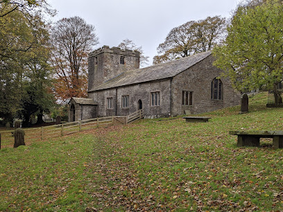
| Description | : | The earliest church on this site was a 9th-century Saxon church. The current structure, which has a Norman tower, dates from the 12th century. Improvements and additions were made in the 17th and 19th centuries. |
frequently asked questions (FAQ):
-
Where is St Peter Church?
St Peter Church is located at Church Lane, East Marton, Skipton Martons Both, Craven District ,North Yorkshire , BD23 3LREngland.
-
St Peter Church cemetery's updated grave count on graveviews.com?
0 memorials
-
Where are the coordinates of the St Peter Church?
Latitude: 53.9522630
Longitude: -2.1415720
Nearby Cemetories:
1. St. Peter's Churchyard
Martons Both, Craven District, England
Coordinate: 53.9522064, -2.1413111
2. St Mary the Virgin Churchyard
Thornton-in-Craven, Craven District, England
Coordinate: 53.9311350, -2.1513350
3. All Saints Churchyard
Broughton, Craven District, England
Coordinate: 53.9492880, -2.1019580
4. Saint Mary-le-Ghyll
Barnoldswick, Pendle Borough, England
Coordinate: 53.9279505, -2.1647004
5. Ghyll Cemetery
Barnoldswick, Pendle Borough, England
Coordinate: 53.9271100, -2.1646700
6. Earby Cemetery
Earby, Pendle Borough, England
Coordinate: 53.9189987, -2.1370001
7. St Andrew Churchyard
Gargrave, Craven District, England
Coordinate: 53.9811830, -2.1054420
8. Salterforth Cemetery
Salterforth, Pendle Borough, England
Coordinate: 53.9123170, -2.1654010
9. St. Peter's Churchyard
Coniston Cold, Craven District, England
Coordinate: 53.9944380, -2.1493870
10. Saint Michael's Church
Bracewell, Pendle Borough, England
Coordinate: 53.9322400, -2.2099730
11. St Mary's Churchyard
Kelbrook, Pendle Borough, England
Coordinate: 53.8991000, -2.1494100
12. Bethel Chapel Cemetery
Lothersdale, Craven District, England
Coordinate: 53.9102184, -2.0749640
13. St Mary the Virgin Churchyard
Carleton, Craven District, England
Coordinate: 53.9442300, -2.0417800
14. Christ Churchyard
Lothersdale, Craven District, England
Coordinate: 53.9097000, -2.0578600
15. Waltonwrays Cemetery and Skipton Crematorium
Skipton, Craven District, England
Coordinate: 53.9505500, -2.0272300
16. St. Aidan's Churchyard
Hellifield, Craven District, England
Coordinate: 54.0042070, -2.2201370
17. St Stephen Roman Catholic Churchyard
Skipton, Craven District, England
Coordinate: 53.9631760, -2.0210240
18. St. Mary the Virgin Churchyard
Gisburn, Ribble Valley Borough, England
Coordinate: 53.9356080, -2.2605210
19. Tarn Moor Memorial Woodland Burial Ground
Skipton, Craven District, England
Coordinate: 53.9759590, -2.0254260
20. Christ Churchyard
Skipton, Craven District, England
Coordinate: 53.9581200, -2.0188910
21. Raikes Road Burial Ground
Skipton, Craven District, England
Coordinate: 53.9643822, -2.0196819
22. Skipton War Memorial
Skipton, Craven District, England
Coordinate: 53.9627100, -2.0161680
23. Holy Trinity Churchyard
Skipton, Craven District, England
Coordinate: 53.9633250, -2.0161180
24. Friends Burial Ground at Skipton
Skipton, Craven District, England
Coordinate: 53.9599220, -2.0148630