
| Birth | : | 17 Oct 1912 |
| Death | : | 19 Oct 2001 |
| Burial | : | St. Mary's Churchyard, Eastham, Metropolitan Borough of Wirral, England |
| Coordinate | : | 53.3133500, -2.9614500 |
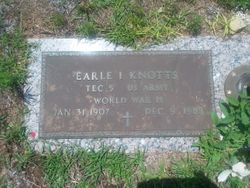
| Description | : | Services for Ella Mae I. Knotts, 89, will be held at 2 p.m. Monday at North United Methodist Church, with internment in Bull Swamp Baptist Church Cemetery. The Rev. Matt Rucker will officiate. The family will receive friends at Culler-McAlhany Funeral Home from 6-8 tonight. Memorials may be made to North United Methodist Church. Mrs. Knotts, widow of Earle I. Knotts, died October 19, 2001. A native of St. Matthews, she was a daughter of the late Lewis Robinson and Fannie Hayden Inabinet. Mrs. Knotts was a member of North United Methodist Church, where she was a former Sunday school... Read More |
frequently asked questions (FAQ):
-
Where is Ella Mae Inabinet Knotts's memorial?
Ella Mae Inabinet Knotts's memorial is located at: St. Mary's Churchyard, Eastham, Metropolitan Borough of Wirral, England.
-
When did Ella Mae Inabinet Knotts death?
Ella Mae Inabinet Knotts death on 19 Oct 2001 in
-
Where are the coordinates of the Ella Mae Inabinet Knotts's memorial?
Latitude: 53.3133500
Longitude: -2.9614500
Family Members:
Parent

Spouse
Siblings
Flowers:


Nearby Cemetories:
1. St. Mary's Churchyard
Eastham, Metropolitan Borough of Wirral, England
Coordinate: 53.3133500, -2.9614500
2. Plymyard Cemetery
Bromborough, Metropolitan Borough of Wirral, England
Coordinate: 53.3207700, -2.9725400
3. Mayfields Woodland Remembrance Park
Eastham, Metropolitan Borough of Wirral, England
Coordinate: 53.3255100, -2.9550200
4. St Mary of the Angels Hooton
Hooton, Cheshire West and Chester Unitary Authority, England
Coordinate: 53.2971800, -2.9569700
5. St Barnabas Bromborough
Bromborough, Metropolitan Borough of Wirral, England
Coordinate: 53.3324700, -2.9784000
6. St. Paul's Churchyard
Hooton, Cheshire West and Chester Unitary Authority, England
Coordinate: 53.2902200, -2.9511400
7. Overpool Cemetery
Ellesmere Port, Cheshire West and Chester Unitary Authority, England
Coordinate: 53.2881800, -2.9215590
8. Christ Church Churchyard
Willaston, Cheshire East Unitary Authority, England
Coordinate: 53.2929220, -3.0086860
9. Christ Church Churchyard
Willaston, Cheshire West and Chester Unitary Authority, England
Coordinate: 53.2925500, -3.0086100
10. St John The Evangelist
Great Sutton, Cheshire West and Chester Unitary Authority, England
Coordinate: 53.2733100, -2.9364800
11. St Andrews Parish Churchyard
Bebington, Metropolitan Borough of Wirral, England
Coordinate: 53.3479800, -3.0035400
12. Christ Church Churchyard
Port Sunlight, Metropolitan Borough of Wirral, England
Coordinate: 53.3534920, -2.9953750
13. Christ Church Churchyard
Ellesmere Port, Cheshire West and Chester Unitary Authority, England
Coordinate: 53.2861000, -2.8950800
14. All Saints Churchyard
Thornton Hough, Metropolitan Borough of Wirral, England
Coordinate: 53.3203500, -3.0444780
15. Saint Michael's Church
Garston, Metropolitan Borough of Liverpool, England
Coordinate: 53.3518400, -2.8973800
16. Bebington Cemetery
Bebington, Metropolitan Borough of Wirral, England
Coordinate: 53.3588030, -3.0165370
17. St Austin's Churchyard
Grassendale, Metropolitan Borough of Liverpool, England
Coordinate: 53.3614552, -2.9124587
18. Holy Trinity Churchyard
Capenhurst, Cheshire West and Chester Unitary Authority, England
Coordinate: 53.2574000, -2.9492900
19. Christ Church
Bebington, Metropolitan Borough of Wirral, England
Coordinate: 53.3584460, -3.0254810
20. St. Anne's Churchyard
Aigburth, Metropolitan Borough of Liverpool, England
Coordinate: 53.3695480, -2.9305760
21. Neston Cemetery
Neston, Cheshire West and Chester Unitary Authority, England
Coordinate: 53.2943100, -3.0571400
22. St. Peter's Churchyard
Bebington, Metropolitan Borough of Wirral, England
Coordinate: 53.3692500, -3.0021020
23. St Michael's in the Hamlet
Aigburth, Metropolitan Borough of Liverpool, England
Coordinate: 53.3765870, -2.9499850
24. St Nicholas Churchyard
Burton, Cheshire West and Chester Unitary Authority, England
Coordinate: 53.2616430, -3.0251070