
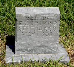
Ella May King
| Birth | : | 14 Sep 1900 |
| Death | : | 1 May 1903 |
| Burial | : | Saint Mary Cemetery, Union County, USA |
| Coordinate | : | 42.8520584, -96.7877502 |
| Plot | : | Row J, Space 79 |
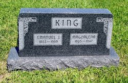
| Description | : | King-On May 1, 1903, near McLain, Kansas, Ella May, daughter of E. J. and Magdelena King, aged 2Y., 7M., 17D. She was taken suddenly ill on the night of April 1. At 10 p.m. she called and said she was sick and we indeed found her so. From the very first it seemed to us that she was going home. In a week she lay a helpless little sufferer from a gathering in her head and inflammation of the bowels. After another week of suffering we had prayer according to James 5, and she seemed healed instantly of her pain,... Read More |
frequently asked questions (FAQ):
-
Where is Ella May King's memorial?
Ella May King's memorial is located at: Saint Mary Cemetery, Union County, USA.
-
When did Ella May King death?
Ella May King death on 1 May 1903 in
-
Where are the coordinates of the Ella May King's memorial?
Latitude: 42.8520584
Longitude: -96.7877502
Family Members:
Parent

Siblings
Flowers:


Nearby Cemetories:
1. Saint Mary Cemetery
Union County, USA
Coordinate: 42.8520584, -96.7877502
2. Ahlsborg Lutheran Cemetery
Union County, USA
Coordinate: 42.8228000, -96.7612000
3. Brule Creek Cemetery
Spink Township, Union County, USA
Coordinate: 42.8346510, -96.7324350
4. Pleasant Hill Cemetery Old
Spink, Union County, USA
Coordinate: 42.8588462, -96.7215592
5. Saint Peter Greenfield Cemetery
Vermillion, Clay County, USA
Coordinate: 42.8608017, -96.8644028
6. Dowlin Cemetery
Burbank, Clay County, USA
Coordinate: 42.7789001, -96.8107986
7. Pleasant Hill Cemetery
Spink, Union County, USA
Coordinate: 42.8741000, -96.6876000
8. Saint Agnes Cemetery
Vermillion, Clay County, USA
Coordinate: 42.7872009, -96.8499985
9. Olbue Lerseth Cemetery
Beresford, Union County, USA
Coordinate: 42.9281100, -96.7516100
10. First Brule Creek Cemetery
Elk Point, Union County, USA
Coordinate: 42.7943993, -96.7069016
11. Roseni Lutheran Church Cemetery
Beresford, Union County, USA
Coordinate: 42.9388000, -96.7639000
12. Rockfield Cemetery
Clay County, USA
Coordinate: 42.9397011, -96.8302994
13. Clay Point Cemetery
Prairie Center Township, Clay County, USA
Coordinate: 42.8987700, -96.9065600
14. Nora Cemetery
Union County, USA
Coordinate: 42.9314003, -96.7061005
15. Union County Poor Farm Cemetery
Union County, USA
Coordinate: 42.7649210, -96.7077580
16. Saint Paul Cemetery
Elk Point, Union County, USA
Coordinate: 42.7641983, -96.7061005
17. Bluff View Cemetery
Vermillion, Clay County, USA
Coordinate: 42.7714000, -96.9056000
18. Saint Agnes Calvary Cemetery
Vermillion, Clay County, USA
Coordinate: 42.7715900, -96.9072100
19. Spirit Mound Cemetery
Clay County, USA
Coordinate: 42.8885994, -96.9424973
20. Richland Cemetery
Richland, Union County, USA
Coordinate: 42.7682991, -96.6624985
21. Gores Bluff Cemetery
Union County, USA
Coordinate: 42.8035069, -96.6260468
22. Dalesburg Lutheran Cemetery
Vermillion, Clay County, USA
Coordinate: 42.9389424, -96.9242594
23. Saint Joseph Catholic Church Cemetery
Emmet, Union County, USA
Coordinate: 42.9836950, -96.7466350
24. Dalesburg Baptist Cemetery
Dalesburg, Clay County, USA
Coordinate: 42.9675102, -96.8850403