
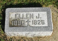

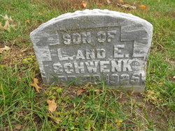
Ellen Julia Vollmer Schwenk
| Birth | : | 9 Dec 1890 Templeton, Carroll County, Iowa, USA |
| Death | : | 8 Dec 1926 Rochester, Olmsted County, Minnesota, USA |
| Burial | : | Mount Olivet Cemetery, Carroll, Carroll County, USA |
| Coordinate | : | 42.0536340, -94.8595510 |
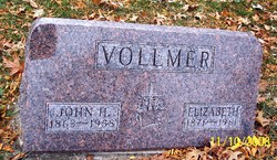
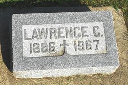
| Description | : | Ellen was the daughter of John Vollmer and Elizabeth Macke. She married Lawrence Schwenk on June 26, 1911 at Templeton, Iowa. They were the parents of Vincent, Phyllis, Betty, and John Joseph. Dec 16, 1926 - Carroll Times - Funeral services for Mrs. Lawrence Schwenk, whose death was briefly mentioned in the last issue of The Carroll Times, were held at the 3t. Lawrence church Saturday morning, December 11, at 10 o'clock, the requiem high mass being conducted by Rev. Fr. Joseph Cordes. The pallbearers were Messrs J.P. Cranny, F. F.J. Halbig, E.M. Jacobs, Joe O'Herron, A.F. Matt and... Read More |
frequently asked questions (FAQ):
-
Where is Ellen Julia Vollmer Schwenk's memorial?
Ellen Julia Vollmer Schwenk's memorial is located at: Mount Olivet Cemetery, Carroll, Carroll County, USA.
-
When did Ellen Julia Vollmer Schwenk death?
Ellen Julia Vollmer Schwenk death on 8 Dec 1926 in Rochester, Olmsted County, Minnesota, USA
-
Where are the coordinates of the Ellen Julia Vollmer Schwenk's memorial?
Latitude: 42.0536340
Longitude: -94.8595510
Family Members:
Parent

Spouse
Siblings

Children
Flowers:


Nearby Cemetories:
1. Mount Olivet Cemetery
Carroll, Carroll County, USA
Coordinate: 42.0536340, -94.8595510
2. Carroll City Cemetery
Carroll, Carroll County, USA
Coordinate: 42.0560963, -94.8599856
3. Holy Angels Cemetery
Carroll County, USA
Coordinate: 42.0014000, -94.9141998
4. Saint Francis Cemetery
Maple River, Carroll County, USA
Coordinate: 42.0969009, -94.9372025
5. Saint Marys Catholic Cemetery
Willey, Carroll County, USA
Coordinate: 41.9783363, -94.8212204
6. Holy Family Cemetery
Lidderdale, Carroll County, USA
Coordinate: 42.1178017, -94.7839966
7. West Lawn Cemetery
Glidden, Carroll County, USA
Coordinate: 42.0649986, -94.7406006
8. Immanuel Cemetery
Lidderdale, Carroll County, USA
Coordinate: 42.1389008, -94.8022003
9. Saint Augustine Cemetery
Halbur, Carroll County, USA
Coordinate: 42.0066986, -94.9744034
10. Our Lady Of Mount Carmel Cemetery
Mount Carmel, Carroll County, USA
Coordinate: 42.1547012, -94.9088974
11. Arcadia Cemetery
Arcadia Township, Carroll County, USA
Coordinate: 42.1000680, -95.0130550
12. East Liberty Cemetery
Lidderdale, Carroll County, USA
Coordinate: 42.1591988, -94.7636032
13. McCurdy Cemetery
Carroll County, USA
Coordinate: 41.9403000, -94.7649994
14. Saint Johns Catholic Cemetery
Arcadia, Carroll County, USA
Coordinate: 42.0855406, -95.0341577
15. Dickson Cemetery
Glidden Township, Carroll County, USA
Coordinate: 42.1074982, -94.6939011
16. Saint Bernards Cemetery
Breda, Carroll County, USA
Coordinate: 42.1786003, -94.9732971
17. Elba Cemetery
Templeton, Carroll County, USA
Coordinate: 41.9068985, -94.9131012
18. Sacred Heart Cemetery
Templeton, Carroll County, USA
Coordinate: 41.9138746, -94.9460994
19. Dedham Cemetery
Dedham, Carroll County, USA
Coordinate: 41.8993988, -94.8225021
20. Saint Josephs Cemetery
Dedham, Carroll County, USA
Coordinate: 41.8993988, -94.8210983
21. North Coon Cemetery
Carroll County, USA
Coordinate: 42.1260986, -94.6716995
22. Old Carrollton Cemetery
Carrollton, Carroll County, USA
Coordinate: 41.9233017, -94.7403030
23. Lanesboro Cemetery
Lanesboro, Carroll County, USA
Coordinate: 42.1810989, -94.7230988
24. Luckow Cemetery
Auburn, Sac County, USA
Coordinate: 42.2168999, -94.9266968