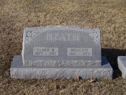
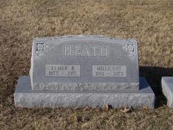
Elmer Bertram Heath
| Birth | : | 15 Apr 1875 Seneca, Nemaha County, Kansas, USA |
| Death | : | 5 Jan 1971 Topeka, Shawnee County, Kansas, USA |
| Burial | : | Agawam Cemetery, Wareham, Plymouth County, USA |
| Coordinate | : | 41.7463989, -70.6908035 |
| Plot | : | Section A west |
| Description | : | TOPEKA CAPITAL-JOURNAL - JANUARY 5, 1971 Elmer B. Heath, 95, 1200 Harrison, died Tuesday morning in a private home following a lengthy illness. He was born April 15, 1875, in Seneca and was a resident of Holton for many years until moving to Topeka in 1939. He worked as an interior decorator until his retirement many years ago. Survivors include his widow, Millicent, of the home, a daughter, Miss Annabelle Heath, Washington, D.C.; three sons, John Heath, 1178 Clay; Robert L. Heath, 1244 Western, and Lloyd Heath, 1200 Harrison; two sisters, Mrs. Belle Becton, Long Beach, Calif., and Mrs. Blanche Chenoweth, Cheyenne; six grandchildren,... Read More |
frequently asked questions (FAQ):
-
Where is Elmer Bertram Heath's memorial?
Elmer Bertram Heath's memorial is located at: Agawam Cemetery, Wareham, Plymouth County, USA.
-
When did Elmer Bertram Heath death?
Elmer Bertram Heath death on 5 Jan 1971 in Topeka, Shawnee County, Kansas, USA
-
Where are the coordinates of the Elmer Bertram Heath's memorial?
Latitude: 41.7463989
Longitude: -70.6908035
Family Members:
Parent
Spouse
Siblings
Children
Flowers:
Nearby Cemetories:
1. Agawam Cemetery
Wareham, Plymouth County, USA
Coordinate: 41.7463989, -70.6908035
2. Saint Patricks Cemetery
Wareham, Plymouth County, USA
Coordinate: 41.7703018, -70.7264023
3. Centre Cemetery
Wareham, Plymouth County, USA
Coordinate: 41.7708015, -70.7277985
4. Long Neck Cemetery
Wareham, Plymouth County, USA
Coordinate: 41.7461014, -70.6369019
5. Nickerson Burial Ground
Plymouth, Plymouth County, USA
Coordinate: 41.7642740, -70.6306530
6. Tobey-Fearing-Bliss Cemetery (Defunct)
Wareham, Plymouth County, USA
Coordinate: 41.7722600, -70.7464100
7. Point Road Memorial Forest
Marion, Plymouth County, USA
Coordinate: 41.7071400, -70.7385050
8. Blankenship Cemetery
Marion, Plymouth County, USA
Coordinate: 41.7076200, -70.7392100
9. Monument Neck Cemetery
Gray Gables, Barnstable County, USA
Coordinate: 41.7346001, -70.6128006
10. Little Neck Cemetery
Marion, Plymouth County, USA
Coordinate: 41.7175200, -70.7624900
11. Oakland Grove Cemetery
Bourne, Barnstable County, USA
Coordinate: 41.7402992, -70.6042023
12. Bourne Family Cemetery
Bourne, Barnstable County, USA
Coordinate: 41.7501602, -70.6032104
13. Friends Burial Ground
Marion, Plymouth County, USA
Coordinate: 41.7279129, -70.7757416
14. North Marion Cemetery
Marion, Plymouth County, USA
Coordinate: 41.7280884, -70.7763062
15. Monument Beach Cemetery
Monument Beach, Barnstable County, USA
Coordinate: 41.7151800, -70.6094600
16. Bourne Family Cemetery #02
Bourne, Barnstable County, USA
Coordinate: 41.7577230, -70.6001190
17. Old Bourne Cemetery
Bourne, Barnstable County, USA
Coordinate: 41.7386017, -70.5986023
18. Saint Gabriels Episcopal Memorial Garden
Marion, Plymouth County, USA
Coordinate: 41.7020200, -70.7626500
19. Old Landing Cemetery
Marion, Plymouth County, USA
Coordinate: 41.7103004, -70.7707977
20. Bourne Village Cemetery
Bourne, Barnstable County, USA
Coordinate: 41.7425117, -70.5938110
21. Perry Family Cemetery
Rochester, Plymouth County, USA
Coordinate: 41.7501840, -70.7914780
22. Woodside Cemetery
Rochester, Plymouth County, USA
Coordinate: 41.7848816, -70.7774887
23. Evergreen Cemetery
Marion, Plymouth County, USA
Coordinate: 41.6985435, -70.7698517
24. Hillside Cemetery
Rochester, Plymouth County, USA
Coordinate: 41.7750015, -70.7889023

