
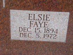


Elsie Fay Wilson Butcher
| Birth | : | 15 Dec 1894 Mills County, Iowa, USA |
| Death | : | 5 Dec 1972 Omaha, Douglas County, Nebraska, USA |
| Burial | : | Wesley Chapel Cemetery, Henderson, Mills County, USA |
| Coordinate | : | 41.1019249, -95.4987793 |
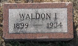
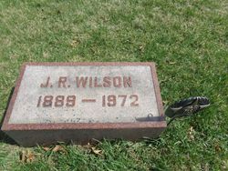
| Description | : | Elsie Faye Wilson was born December 15, 1894 in the Wesley Chapel Community to Edward and Martha Jones Wilson. She received her early education in the Mills County Schools and attended Simpson College and the State Normal College at Maryville, Missouri. She joined the Wesley Chapel Church early in life and held offices in the Church Sunday School and Womens Society. On August 15, 1922, she was married to Waldon Sowers of the same neighborhood. Two sons were born to them, Kenneth Waldon and Gerald LaVern, both of Omaha, Nebraska. On March 22, 1934, the husband and father passed away and Faye... Read More |
frequently asked questions (FAQ):
-
Where is Elsie Fay Wilson Butcher's memorial?
Elsie Fay Wilson Butcher's memorial is located at: Wesley Chapel Cemetery, Henderson, Mills County, USA.
-
When did Elsie Fay Wilson Butcher death?
Elsie Fay Wilson Butcher death on 5 Dec 1972 in Omaha, Douglas County, Nebraska, USA
-
Where are the coordinates of the Elsie Fay Wilson Butcher's memorial?
Latitude: 41.1019249
Longitude: -95.4987793
Family Members:
Parent
Spouse
Siblings
Children

Flowers:


Nearby Cemetories:
1. Wesley Chapel Cemetery
Henderson, Mills County, USA
Coordinate: 41.1019249, -95.4987793
2. Saylers Farm Cemetery
Henderson, Mills County, USA
Coordinate: 41.1083300, -95.4919440
3. Cotten Cemetery
Mills County, USA
Coordinate: 41.0845000, -95.5167000
4. Wearin Cemetery
Malvern, Mills County, USA
Coordinate: 41.0395000, -95.5313000
5. Farm Creek Cemetery
Henderson, Mills County, USA
Coordinate: 41.1319008, -95.4186020
6. East Liberty Cemetery
Malvern, Mills County, USA
Coordinate: 41.0592346, -95.6005020
7. North Grove Cemetery
Hastings, Mills County, USA
Coordinate: 41.0161018, -95.4618988
8. Hastings Cemetery
Hastings, Mills County, USA
Coordinate: 41.0097008, -95.4993973
9. Emerson Cemetery
Emerson, Mills County, USA
Coordinate: 41.0325012, -95.4021988
10. Lowens Cemetery
Garfield Township, Montgomery County, USA
Coordinate: 41.0527728, -95.3758292
11. Silver City Cemetery
Silver City, Mills County, USA
Coordinate: 41.1042442, -95.6380005
12. Macedonia Cemetery
Macedonia, Pottawattamie County, USA
Coordinate: 41.1921997, -95.4167023
13. Old Town Cemetery
Macedonia, Pottawattamie County, USA
Coordinate: 41.2030983, -95.4421997
14. South Grove Cemetery
Mills County, USA
Coordinate: 40.9775009, -95.4931030
15. Malvern Cemetery
Malvern, Mills County, USA
Coordinate: 40.9886017, -95.5785980
16. Parker Cemetery
White Cloud, Mills County, USA
Coordinate: 40.9737649, -95.5184363
17. Buckner Cemetery
Wales, Montgomery County, USA
Coordinate: 41.1595600, -95.3440700
18. Mormon Cemetery
Macedonia, Pottawattamie County, USA
Coordinate: 41.1885986, -95.3557663
19. Hillsdale Cemetery
Glenwood, Mills County, USA
Coordinate: 41.0097008, -95.6427994
20. Gomer Cemetery
Wales, Montgomery County, USA
Coordinate: 41.1171989, -95.3082962
21. Mills County Farm Cemetery
Glenwood, Mills County, USA
Coordinate: 41.0417930, -95.6756530
22. Mineola Cemetery
Mineola, Mills County, USA
Coordinate: 41.1391130, -95.6941800
23. Zion Congregational Cemetery
Treynor, Pottawattamie County, USA
Coordinate: 41.2325090, -95.6079200
24. Carson Cemetery
Carson, Pottawattamie County, USA
Coordinate: 41.2392006, -95.4044037