
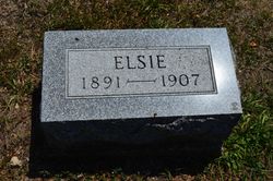
Elsie Irene Skoglund
| Birth | : | 29 Aug 1892 Dayton, Webster County, Iowa, USA |
| Death | : | 9 Jul 1907 Fort Dodge, Webster County, Iowa, USA |
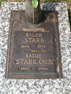
| Burial | : | Dayton Cemetery, Dayton, Webster County, USA |
| Coordinate | : | 42.2675000, -94.0755000 |
| Plot | : | Section 1 |
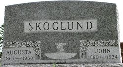
| Description | : | Dayton Review July 18, 1907 OBITUARY Esther (Elsie) Skoglund, daughter of Mr. and Mrs. John Skoglund, was born in this vicinity, July (August) 29, 1891, and died at Fort Dodge July 9, 1907, aged 15 years, 11 months, 10 days. She was reared on the family homestead west of town, where she was always surrounded by loving friends, attracted by her kindly traits of character. She was a member of this year's confirmation class of Lutheran church of this place, being confirmed into church with her classmates. She was attacked by that dread disease tuberculosis, and was unable... Read More |
frequently asked questions (FAQ):
-
Where is Elsie Irene Skoglund's memorial?
Elsie Irene Skoglund's memorial is located at: Dayton Cemetery, Dayton, Webster County, USA.
-
When did Elsie Irene Skoglund death?
Elsie Irene Skoglund death on 9 Jul 1907 in Fort Dodge, Webster County, Iowa, USA
-
Where are the coordinates of the Elsie Irene Skoglund's memorial?
Latitude: 42.2675000
Longitude: -94.0755000
Family Members:
Parent

Siblings
Flowers:


Nearby Cemetories:
1. Dayton Cemetery
Dayton, Webster County, USA
Coordinate: 42.2675000, -94.0755000
2. Christ the King Catholic Cemetery
Dayton, Webster County, USA
Coordinate: 42.2601929, -94.0727539
3. Bass Cemetery
Dayton, Webster County, USA
Coordinate: 42.2966995, -94.0149994
4. Swedish Lutheran Church Cemetery
Dayton, Webster County, USA
Coordinate: 42.2175000, -94.1065000
5. Oak Grove Cemetery
Lehigh, Webster County, USA
Coordinate: 42.3438988, -94.0475006
6. Hardin Township Cemetery
Hardin Township, Webster County, USA
Coordinate: 42.2411003, -93.9708023
7. Linn Cemetery
Pilot Mound, Boone County, USA
Coordinate: 42.2045330, -93.9970230
8. Lawn Cemetery
Boone County, USA
Coordinate: 42.1771011, -94.0867996
9. West Lawn Cemetery
Lehigh, Webster County, USA
Coordinate: 42.3616982, -94.0678024
10. McGuire Bend Cemetery
Dayton, Webster County, USA
Coordinate: 42.3410000, -93.9880000
11. Runyan Cemetery
Pilot Mound, Boone County, USA
Coordinate: 42.1749992, -94.0015030
12. Pilot Mound Cemetery
Pilot Mound, Boone County, USA
Coordinate: 42.1636200, -94.0282600
13. Vegors Cemetery
Webster County, USA
Coordinate: 42.3177986, -93.9421997
14. Lost Grove Cemetery
Harcourt, Webster County, USA
Coordinate: 42.2583008, -94.2331009
15. Hooks Point Cemetery
Hamilton County, USA
Coordinate: 42.2944530, -93.9199090
16. Oakwood Cemetery
Stratford, Hamilton County, USA
Coordinate: 42.2942009, -93.9182968
17. Hartman Cemetery
Lehigh, Webster County, USA
Coordinate: 42.3666397, -93.9835627
18. White Cemetery
Boone County, USA
Coordinate: 42.1777992, -93.9636002
19. Border Plains Cemetery
Border Plains, Webster County, USA
Coordinate: 42.3917000, -94.0448000
20. Ober and Scott Cemetery
Duncombe, Webster County, USA
Coordinate: 42.3841390, -93.9982856
21. Union Cemetery
Boxholm, Boone County, USA
Coordinate: 42.1369019, -94.0852966
22. Renner Cemetery
Boone County, USA
Coordinate: 42.1380420, -94.1256570
23. Otho Cemetery
Otho, Webster County, USA
Coordinate: 42.4025002, -94.1153030
24. Schlicht Cemetery
Fraser, Boone County, USA
Coordinate: 42.1444200, -93.9780100