
| Birth | : | 20 Jan 1845 Monmouth County, New Jersey, USA |
| Death | : | 15 Nov 1903 Malvern, Mills County, Iowa, USA |
| Burial | : | Malvern Cemetery, Malvern, Mills County, USA |
| Coordinate | : | 40.9886017, -95.5785980 |
| Plot | : | Section 1 Lot 163 |
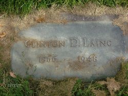
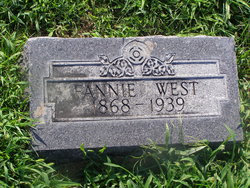
| Description | : | Elwood is the son of Abel & Emily A. (Breese) Laing. Elwood married Mary Catherine Wooding. Elwood and Mary are the parents of: Clinton Dewitt b. June 12, 1866 d. Mary Frances b. March 5, 1868 d. May 12, 1939 Willis Bernard b. March 8, 1870 d. Sarah Cordealis b. September 11, 1873 d. October 22, 1946 Norwood Brooks b. December 5, 1874 d. July 2, 1879 Clara Estella b. January 20, 1877 d. February 4, 1900 Mabel b. April 8, 1883 d. October 19, 1956 |
frequently asked questions (FAQ):
-
Where is Elwood Laing's memorial?
Elwood Laing's memorial is located at: Malvern Cemetery, Malvern, Mills County, USA.
-
When did Elwood Laing death?
Elwood Laing death on 15 Nov 1903 in Malvern, Mills County, Iowa, USA
-
Where are the coordinates of the Elwood Laing's memorial?
Latitude: 40.9886017
Longitude: -95.5785980
Family Members:
Parent
Spouse

Siblings
Children
Flowers:


Nearby Cemetories:
1. Malvern Cemetery
Malvern, Mills County, USA
Coordinate: 40.9886017, -95.5785980
2. Parker Cemetery
White Cloud, Mills County, USA
Coordinate: 40.9737649, -95.5184363
3. Hillsdale Cemetery
Glenwood, Mills County, USA
Coordinate: 41.0097008, -95.6427994
4. Wearin Cemetery
Malvern, Mills County, USA
Coordinate: 41.0395000, -95.5313000
5. Hastings Cemetery
Hastings, Mills County, USA
Coordinate: 41.0097008, -95.4993973
6. South Grove Cemetery
Mills County, USA
Coordinate: 40.9775009, -95.4931030
7. East Liberty Cemetery
Malvern, Mills County, USA
Coordinate: 41.0592346, -95.6005020
8. Fairview Cemetery
Tabor, Mills County, USA
Coordinate: 40.9453011, -95.6716995
9. Mills County Farm Cemetery
Glenwood, Mills County, USA
Coordinate: 41.0417930, -95.6756530
10. North Grove Cemetery
Hastings, Mills County, USA
Coordinate: 41.0161018, -95.4618988
11. Bomar Family Cemetery
Mills County, USA
Coordinate: 41.0369400, -95.6941700
12. Cotten Cemetery
Mills County, USA
Coordinate: 41.0845000, -95.5167000
13. Estes Cemetery
Tabor, Mills County, USA
Coordinate: 40.9425011, -95.7080994
14. Randolph Cemetery
Randolph, Fremont County, USA
Coordinate: 40.8769493, -95.5695038
15. Tabor Cemetery
Tabor, Mills County, USA
Coordinate: 40.9035260, -95.6799460
16. Riverside Cemetery
Randolph, Fremont County, USA
Coordinate: 40.8806000, -95.5269012
17. Pottawattamie Chief Waubonsie Burial Site
Mills County, USA
Coordinate: 40.9236100, -95.7086100
18. Waubonsie Cemetery
Mills County, USA
Coordinate: 40.9451370, -95.7310791
19. Silver City Cemetery
Silver City, Mills County, USA
Coordinate: 41.1042442, -95.6380005
20. Glenwood Resource Center Cemetery
Glenwood, Mills County, USA
Coordinate: 41.0361720, -95.7338590
21. Wesley Chapel Cemetery
Henderson, Mills County, USA
Coordinate: 41.1019249, -95.4987793
22. Rhodes Cemetery
Tabor, Fremont County, USA
Coordinate: 40.9011002, -95.7097015
23. Saylers Farm Cemetery
Henderson, Mills County, USA
Coordinate: 41.1083300, -95.4919440
24. Emerson Cemetery
Emerson, Mills County, USA
Coordinate: 41.0325012, -95.4021988