
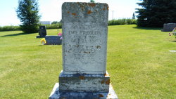

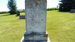
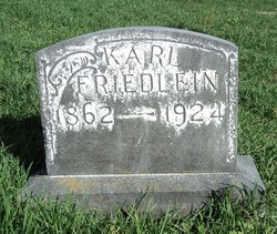
Emil Friedlein
| Birth | : | 15 Feb 1859 Bavaria (Bayern), Germany |
| Death | : | 23 Jul 1934 Guttenberg, Clayton County, Iowa, USA |
| Burial | : | Saint Johns Cemetery, Jefferson Township, Clayton County, USA |
| Coordinate | : | 42.7497000, -91.1133000 |
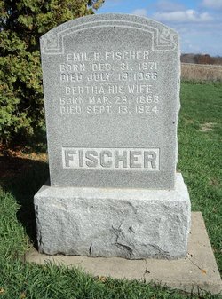
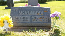
| Description | : | Born in Bavaria on Feb. 15, 1859, his father is John Friedlein and mother Christianna (Bletterlein) Friedlein. His immigration date is 1 July, 1883 and the next year "1884" he is married to Miss Louisa Fisher who was born in Saxe-Meiningen, Germany. He is the father of Rose Pauline Magarete, Carolina, Harriet, Paul J. and Hilda E. Friedlein. On 23 August 1934, he dies of cancer at the home of his daugher Harriet Anderegg. Per burial record, survived by Lena Anderegg, Harriett Anderegg, Hilda Dickson, Paul Friedlein. He is 75 years, 6 mo. and 10 days, per burial record. |
frequently asked questions (FAQ):
-
Where is Emil Friedlein's memorial?
Emil Friedlein's memorial is located at: Saint Johns Cemetery, Jefferson Township, Clayton County, USA.
-
When did Emil Friedlein death?
Emil Friedlein death on 23 Jul 1934 in Guttenberg, Clayton County, Iowa, USA
-
Where are the coordinates of the Emil Friedlein's memorial?
Latitude: 42.7497000
Longitude: -91.1133000
Family Members:
Parent

Spouse
Siblings
Children
Flowers:


Nearby Cemetories:
1. Saint Johns Cemetery
Jefferson Township, Clayton County, USA
Coordinate: 42.7497000, -91.1133000
2. Guttenberg Cemetery
Guttenberg, Clayton County, USA
Coordinate: 42.7691994, -91.1035995
3. Saint Marys Cemetery
Guttenberg, Clayton County, USA
Coordinate: 42.7691994, -91.1352997
4. Mount Olivet Cemetery
Guttenberg, Clayton County, USA
Coordinate: 42.7764840, -91.1083560
5. Bierer Cemetery
Millville, Clayton County, USA
Coordinate: 42.7230500, -91.0925166
6. Redman Cemetery
Millville, Clayton County, USA
Coordinate: 42.7166755, -91.0852901
7. Friedlein Cemetery
Millville, Clayton County, USA
Coordinate: 42.7080994, -91.1108017
8. Lewis Cemetery
Osterdock, Clayton County, USA
Coordinate: 42.7416000, -91.1834000
9. Storck Cemetery
Guttenberg, Clayton County, USA
Coordinate: 42.7694335, -91.1834638
10. Bethel Cemetery
Osterdock, Clayton County, USA
Coordinate: 42.7041702, -91.1688919
11. Saint Paula Cemetery
Osterdock, Clayton County, USA
Coordinate: 42.7635994, -91.1992035
12. Graham Cemetery
Millville, Clayton County, USA
Coordinate: 42.6833172, -91.1195685
13. Old Saint Marys Cemetery
Glen Haven, Grant County, USA
Coordinate: 42.8078100, -91.0675330
14. Charlotte Cemetery
Glen Haven, Grant County, USA
Coordinate: 42.7933006, -91.0381012
15. Borcherding Cemetery
Jefferson Township, Clayton County, USA
Coordinate: 42.8182983, -91.1414032
16. Goshen Cemetery
Millville, Clayton County, USA
Coordinate: 42.6905594, -91.0544434
17. Saint Michael Cemetery
Clayton County, USA
Coordinate: 42.8055992, -91.1802979
18. Bolsinger Cemetery
Mallory Township, Clayton County, USA
Coordinate: 42.6776340, -91.1424090
19. Duncan Cemetery
Glen Haven, Grant County, USA
Coordinate: 42.8325540, -91.0725940
20. Pioneer Rock Cemetery
Ceres, Clayton County, USA
Coordinate: 42.8230591, -91.1863937
21. Ramsey Cemetery
North Andover, Grant County, USA
Coordinate: 42.7817001, -90.9972000
22. Gockel Cemetery
Glen Haven, Grant County, USA
Coordinate: 42.8224983, -91.0385971
23. Noggle Cemetery
Clayton County, USA
Coordinate: 42.6666580, -91.1654100
24. McClelland Cemetery
Garnavillo, Clayton County, USA
Coordinate: 42.8249879, -91.2084641