


Emilie Mueller Matt
| Birth | : | 10 Nov 1883 Farmersburg, Clayton County, Iowa, USA |
| Death | : | 15 Oct 1968 Postville, Allamakee County, Iowa, USA |
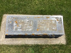
| Burial | : | National Cemetery, National, Clayton County, USA |
| Coordinate | : | 42.9536018, -91.2902985 |
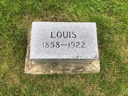
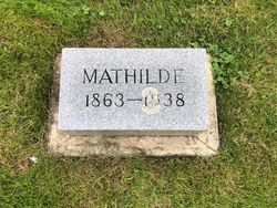
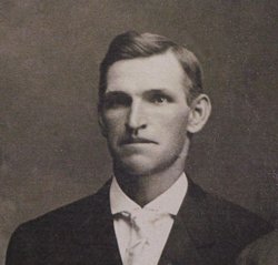
| Description | : | Emilie Mueller was the oldest child of Louis and Matilda Suhr Mueller. She was born 10 November 1883 in Clayton Township, attended school at National, Iowa, high school at McGregor, and Teachers College at Cedar Falls, Iowa. She taught Pioneer Country School for four years and would have more older boys in the classroom during the winter months when they did not have to work on the family farms. Emilie was married to Will Matt on 4 February 1909 at the home of her parents in Farmersburg, Iowa. Both Mr. and Mrs. Matt were of a German background and were... Read More |
frequently asked questions (FAQ):
-
Where is Emilie Mueller Matt's memorial?
Emilie Mueller Matt's memorial is located at: National Cemetery, National, Clayton County, USA.
-
When did Emilie Mueller Matt death?
Emilie Mueller Matt death on 15 Oct 1968 in Postville, Allamakee County, Iowa, USA
-
Where are the coordinates of the Emilie Mueller Matt's memorial?
Latitude: 42.9536018
Longitude: -91.2902985
Family Members:
Parent
Spouse
Siblings
Children


Flowers:


Nearby Cemetories:
1. National Cemetery
National, Clayton County, USA
Coordinate: 42.9536018, -91.2902985
2. Giard Cemetery
Farmersburg, Clayton County, USA
Coordinate: 42.9933014, -91.3080978
3. Bismark Cemetery
Farmersburg, Clayton County, USA
Coordinate: 42.9790000, -91.3500000
4. Farmersburg-Wagner Cemetery
Farmersburg, Clayton County, USA
Coordinate: 42.9481010, -91.3700027
5. Eastman Cemetery
McGregor, Clayton County, USA
Coordinate: 43.0010000, -91.2190000
6. Clayton Center Cemetery
Clayton Center, Clayton County, USA
Coordinate: 42.8841705, -91.3225021
7. Zion Lutheran Cemetery
Clayton Center, Clayton County, USA
Coordinate: 42.8841705, -91.3249969
8. County Home Cemetery
Clayton Center, Clayton County, USA
Coordinate: 42.8916702, -91.3499985
9. Railroad Employee Cemetery
Giard, Clayton County, USA
Coordinate: 43.0305395, -91.3140229
10. Norwegian Church Cemetery
McGregor, Clayton County, USA
Coordinate: 42.9644400, -91.1764100
11. First Evangelical Lutheran Church Cemetery
McGregor, Clayton County, USA
Coordinate: 42.9718000, -91.1760000
12. Colony Catholic Cemetery (Defunct)
Read Township, Clayton County, USA
Coordinate: 42.8830000, -91.3580000
13. Moody Cemetery
McGregor, Clayton County, USA
Coordinate: 43.0030594, -91.1886063
14. Buell Park Cemetery
Mendon Township, Clayton County, USA
Coordinate: 43.0168226, -91.1999590
15. Garnavillo Community Cemetery
Garnavillo, Clayton County, USA
Coordinate: 42.8656000, -91.2422100
16. Garnavillo Cemetery
Garnavillo, Clayton County, USA
Coordinate: 42.8660300, -91.2390100
17. Saint Joseph Cemetery
Garnavillo, Clayton County, USA
Coordinate: 42.8628006, -91.2502975
18. Walton Cemetery
McGregor, Clayton County, USA
Coordinate: 43.0216270, -91.1909350
19. Gooding Cemetery
Wagner Township, Clayton County, USA
Coordinate: 42.9869490, -91.4191570
20. Pleasant Grove Cemetery
McGregor, Clayton County, USA
Coordinate: 43.0266991, -91.1949997
21. Saint Marys Catholic Church Cemetery
McGregor, Clayton County, USA
Coordinate: 43.0213735, -91.1834632
22. Norway Lutheran Church Cemetery
Saint Olaf, Clayton County, USA
Coordinate: 42.9352798, -91.4302826
23. Clayton Cemetery
Clayton, Clayton County, USA
Coordinate: 42.9043999, -91.1641998
24. Saint Wenceslaus Cemetery
McGregor, Clayton County, USA
Coordinate: 43.0593987, -91.3142014