Emma Jean Whitaker Larson
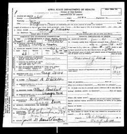
| Birth | : | 21 Oct 1874 Osage, Mitchell County, Iowa, USA |
| Death | : | 20 Jan 1937 Osage, Mitchell County, Iowa, USA |
| Burial | : | Saints Peter and Paul Byzantine Cemetery, Punxsutawney, Jefferson County, USA |
| Coordinate | : | 40.9750000, -78.9706000 |
| Description | : | MRS. LARSON OSAGE, DIES HAD BEEN HOUSEMOTHER OF RAWSON HOUSE AT GRINNELL Osage – Mrs. Emma Larson, 62, died here Wednesday afternoon at the home of her sister, Mrs. R. L. Whitley. She had been in very poor health since Thanksgiving. Emma Whitaker was born here in Osage in October, 1874. In 1894 she was married to Anton Larson. They spent 11 years in Michigan, two years in California, and the remainder of the time here is Osage. Mr. Larson died in 1930. For the past three years Mrs. Larson had been housemother at Rawson... Read More |
frequently asked questions (FAQ):
-
Where is Emma Jean Whitaker Larson's memorial?
Emma Jean Whitaker Larson's memorial is located at: Saints Peter and Paul Byzantine Cemetery, Punxsutawney, Jefferson County, USA.
-
When did Emma Jean Whitaker Larson death?
Emma Jean Whitaker Larson death on 20 Jan 1937 in Osage, Mitchell County, Iowa, USA
-
Where are the coordinates of the Emma Jean Whitaker Larson's memorial?
Latitude: 40.9750000
Longitude: -78.9706000
Family Members:
Parent
Spouse
Siblings
Children
Flowers:
Nearby Cemetories:
1. Saints Peter and Paul Byzantine Cemetery
Punxsutawney, Jefferson County, USA
Coordinate: 40.9750000, -78.9706000
2. Anita Community Cemetery
Anita, Jefferson County, USA
Coordinate: 40.9932450, -78.9790390
3. Adrian-Anita Roman Catholic Cemetery
Anita, Jefferson County, USA
Coordinate: 40.9958000, -78.9805984
4. Anita Cemetery
Anita, Jefferson County, USA
Coordinate: 40.9972500, -78.9770700
5. Saint Peters Reformed Cemetery
Punxsutawney, Jefferson County, USA
Coordinate: 40.9515150, -78.9616910
6. North Findley Street Cemetery
Punxsutawney, Jefferson County, USA
Coordinate: 40.9466000, -78.9724000
7. Ridgemount Cemetery
Punxsutawney, Jefferson County, USA
Coordinate: 40.9719009, -78.9317017
8. Circle Hill Cemetery
Punxsutawney, Jefferson County, USA
Coordinate: 40.9486008, -78.9496994
9. Clayville Cemetery
Punxsutawney, Jefferson County, USA
Coordinate: 40.9470000, -78.9880000
10. Mount Tabor United Methodist Church Cemetery
Battle Hollow, Jefferson County, USA
Coordinate: 41.0030000, -78.9970000
11. Mount Zion Memorial Cemetery
Jefferson County, USA
Coordinate: 40.9794000, -78.9254000
12. Calvary Cemetery
Punxsutawney, Jefferson County, USA
Coordinate: 40.9358215, -78.9930725
13. Olive Cemetery
Oliveburg, Jefferson County, USA
Coordinate: 40.9940000, -79.0270000
14. Horatio Cemetery
Punxsutawney, Jefferson County, USA
Coordinate: 40.9392000, -79.0133000
15. Pifer Cemetery
Jefferson County, USA
Coordinate: 41.0068000, -78.9210000
16. Zion Presbyterian Cemetery
Panic, Jefferson County, USA
Coordinate: 41.0244300, -78.9530800
17. Oak Lawn Cemetery
Cloe, Jefferson County, USA
Coordinate: 40.9300003, -78.9356003
18. Cherva Agudath Achuin Hebrew Cemetery
Cloe, Jefferson County, USA
Coordinate: 40.9293210, -78.9359090
19. Hopewell United Methodist Church Cemetery
Frostburg, Jefferson County, USA
Coordinate: 40.9620000, -79.0393000
20. Saints Peter And Paul Byzantine Catholic Cemetery
Horatio, Jefferson County, USA
Coordinate: 40.9324989, -79.0180969
21. United Brethren Cemetery
Panic, Jefferson County, USA
Coordinate: 41.0362816, -78.9549637
22. Perry Memorial Cemetery
Frostburg, Jefferson County, USA
Coordinate: 40.9599991, -79.0635986
23. McClure Cemetery
Big Run, Jefferson County, USA
Coordinate: 40.9706100, -78.8750300
24. Fairview Cemetery
Big Run, Jefferson County, USA
Coordinate: 40.9740300, -78.8728300


