

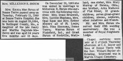
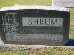
Emma Mae Mathews Shrum
| Birth | : | 29 Aug 1884 Bollinger County, Missouri, USA |
| Death | : | 11 Feb 1969 Bonne Terre, St. Francois County, Missouri, USA |
| Burial | : | Parsons City Cemetery, Parsons, Tucker County, USA |
| Coordinate | : | 39.0894410, -79.6690080 |
| Description | : | Wife of Millerson R. Shrum Married Dec 16 1903 Bollinger County,Missouri Daughter of Henry Z. Mathews & Martha J. Ragsdale |
frequently asked questions (FAQ):
-
Where is Emma Mae Mathews Shrum's memorial?
Emma Mae Mathews Shrum's memorial is located at: Parsons City Cemetery, Parsons, Tucker County, USA.
-
When did Emma Mae Mathews Shrum death?
Emma Mae Mathews Shrum death on 11 Feb 1969 in Bonne Terre, St. Francois County, Missouri, USA
-
Where are the coordinates of the Emma Mae Mathews Shrum's memorial?
Latitude: 39.0894410
Longitude: -79.6690080
Family Members:
Parent
Spouse
Siblings

Children
Flowers:


Nearby Cemetories:
1. Parsons City Cemetery
Parsons, Tucker County, USA
Coordinate: 39.0894410, -79.6690080
2. Goff Memorial Church of the Brethren Cemetery
Hambleton, Tucker County, USA
Coordinate: 39.0826420, -79.6447480
3. Goff Cemetery
Hambleton, Tucker County, USA
Coordinate: 39.0847015, -79.6421967
4. Collett Cemetery
Hambleton, Tucker County, USA
Coordinate: 39.0844002, -79.6410980
5. McNeeley Cemetery
Hendricks, Tucker County, USA
Coordinate: 39.0786018, -79.6378021
6. Fansler Cemetery
Hendricks, Tucker County, USA
Coordinate: 39.0800018, -79.6316986
7. Porterwood Cemetery
Porterwood, Tucker County, USA
Coordinate: 39.0690930, -79.7014900
8. Moore Cemetery
Porterwood, Tucker County, USA
Coordinate: 39.0772750, -79.7108930
9. Bethel Cemetery
Holly Meadows, Tucker County, USA
Coordinate: 39.1363983, -79.6841965
10. Tucker County Poor Farm Cemetery
Holly Meadows, Tucker County, USA
Coordinate: 39.1485980, -79.6655360
11. Mount Zion Cemetery
Saint George, Tucker County, USA
Coordinate: 39.1300583, -79.7348175
12. Sugarlands Brethren Church Cemetery
Thomas, Tucker County, USA
Coordinate: 39.1369170, -79.6102830
13. Irons Chapel Cemetery
Porterwood, Tucker County, USA
Coordinate: 39.0322830, -79.7138850
14. Parsons Family Cemetery
Pleasant Run, Tucker County, USA
Coordinate: 39.0320000, -79.7145000
15. Bonnifield Cemetery
Saint George, Tucker County, USA
Coordinate: 39.1617012, -79.6386032
16. Union Chapel Cemetery
Tucker County, USA
Coordinate: 39.1226040, -79.7756230
17. Harsh Cemetery
Saint George, Tucker County, USA
Coordinate: 39.1197290, -79.7946770
18. Mount Pleasant Cemetery
Saint George, Tucker County, USA
Coordinate: 39.1197590, -79.7947820
19. Jones-Auvil Cemetery
Saint George, Tucker County, USA
Coordinate: 39.1970520, -79.6679160
20. Close Mountain Cemetery
Tucker County, USA
Coordinate: 39.1758200, -79.5716670
21. Hile Cemetery
Tucker County, USA
Coordinate: 39.1946983, -79.6093979
22. Mount Olivet Cemetery
Tucker County, USA
Coordinate: 39.2047005, -79.6442032
23. Clark-Carr Cemetery
Red Creek, Tucker County, USA
Coordinate: 39.0240580, -79.5434710
24. Primitive Baptist Church Cemetery
Montrose, Randolph County, USA
Coordinate: 39.0646330, -79.8187350