
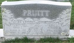
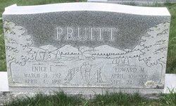
Enice Dolinger Pruitt
| Birth | : | 21 Mar 1912 Grayson County, Virginia, USA |
| Death | : | 4 Apr 1997 Chesterfield, Chesterfield County, South Carolina, USA |
| Burial | : | Haw Orchard Cemetery, Grayson County, USA |
| Coordinate | : | 36.6081009, -81.4950027 |
frequently asked questions (FAQ):
-
Where is Enice Dolinger Pruitt's memorial?
Enice Dolinger Pruitt's memorial is located at: Haw Orchard Cemetery, Grayson County, USA.
-
When did Enice Dolinger Pruitt death?
Enice Dolinger Pruitt death on 4 Apr 1997 in Chesterfield, Chesterfield County, South Carolina, USA
-
Where are the coordinates of the Enice Dolinger Pruitt's memorial?
Latitude: 36.6081009
Longitude: -81.4950027
Family Members:
Parent

Spouse
Siblings
Children
Flowers:


Nearby Cemetories:
1. Haw Orchard Cemetery
Grayson County, USA
Coordinate: 36.6081009, -81.4950027
2. Duvall Family Cemetery
Grayson County, USA
Coordinate: 36.5942130, -81.4864020
3. Timothy F Young Cemetery
Rugby, Grayson County, USA
Coordinate: 36.5955220, -81.4797870
4. Richardson Family Cemetery
Rugby, Grayson County, USA
Coordinate: 36.5975760, -81.4766480
5. Fees Ridge Cemetery
Mouth of Wilson, Grayson County, USA
Coordinate: 36.5936130, -81.5113800
6. Osborne Cemetery
Grayson County, USA
Coordinate: 36.6119003, -81.5216980
7. Cabin Creek Cemetery
Grayson County, USA
Coordinate: 36.6116000, -81.5218000
8. Elijah Franklin Sexton Family Cemetery
Mill Creek, Grayson County, USA
Coordinate: 36.6156371, -81.4691845
9. Gideon Weaver Cemetery
Rugby, Grayson County, USA
Coordinate: 36.6156830, -81.4691750
10. Marshel Jones Cemetery
Rugby, Grayson County, USA
Coordinate: 36.6279230, -81.4816490
11. Greer Cemetery
Grayson County, USA
Coordinate: 36.6180992, -81.5243988
12. Phipps Cemetery
Grayson County, USA
Coordinate: 36.5850830, -81.4794240
13. Samuel Tucker Family Cemetery
Mouth of Wilson, Grayson County, USA
Coordinate: 36.6092250, -81.4614260
14. Kilby Cemetery
Grayson County, USA
Coordinate: 36.5825005, -81.5092010
15. Abram Reedy Cemetery
Rugby, Grayson County, USA
Coordinate: 36.5958220, -81.4602810
16. Roby Testerman Family Cemetery
Mouth of Wilson, Grayson County, USA
Coordinate: 36.5818560, -81.4749340
17. Bill Reedy Cemetery
Rugby, Grayson County, USA
Coordinate: 36.5943000, -81.4571000
18. Barnes Cemetery
Rugby, Grayson County, USA
Coordinate: 36.5847700, -81.4625570
19. Ambrose Spencer Family Cemetery
Ashe County, USA
Coordinate: 36.5720300, -81.4873300
20. John Weiss Cemetery
Rugby, Grayson County, USA
Coordinate: 36.5809630, -81.4629810
21. Corinth Baptist Church Cemetery
Rugby, Grayson County, USA
Coordinate: 36.6119240, -81.4470280
22. Lewis-Perry Cemetery
Grayson County, USA
Coordinate: 36.5849991, -81.5355988
23. Quillin Cemetery
Rugby, Grayson County, USA
Coordinate: 36.6006490, -81.4425210
24. Osborne-Williams Cemetery
Low Gap, Grayson County, USA
Coordinate: 36.6266230, -81.4456550