
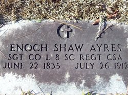

Enoch Shaw Ayres
| Birth | : | 22 Jun 1835 South Carolina, USA |
| Death | : | 26 Jul 1912 South Carolina, USA |
| Burial | : | Nottingham Church Cemetery, Nottingham, Nottingham Unitary Authority, England |
| Coordinate | : | 52.9649830, -1.1558070 |
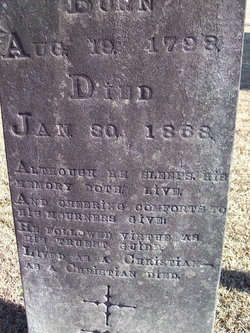
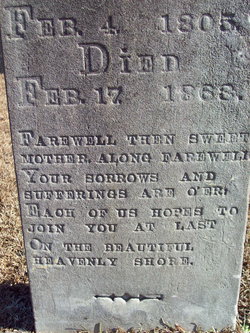
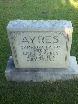
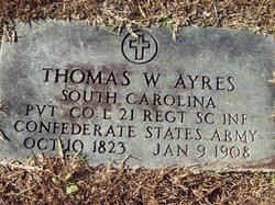
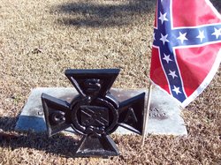
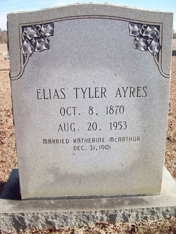
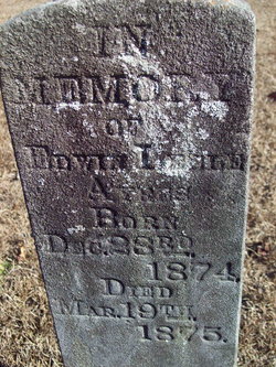
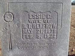
| Description | : | Enoch Shaw Ayres was a son of Rev. William Ayres (1798-1868), a Baptist preacher, and his wife Mary Shaw (1804-1863) of Marion County, South Carolina. He married Samantha "Mantha" Tyler (1846-1931) on 12 Dec. 1865. She was a daughter of Elias Tyler, CSA, and his wife Charity Grainger of Horry County, SC. Enoch and Samantha had nine children: Loula Ayres (1866-1959, Mrs. J. C. Rockwell), William C. Ayres (Aug. 1868-?), Elias Tyler Ayres (1870-1953), Mary Irene Ayres (c.1873), Edwin Leslie Ayres (1874-1875), Herbert Lennon Ayres (Jan. 1876), Essie Corinne Ayres (1878-1922, Mrs. R. T. Renfrow), Irma Ayres (1880-1957, Mrs. Storrs),... Read More |
frequently asked questions (FAQ):
-
Where is Enoch Shaw Ayres's memorial?
Enoch Shaw Ayres's memorial is located at: Nottingham Church Cemetery, Nottingham, Nottingham Unitary Authority, England.
-
When did Enoch Shaw Ayres death?
Enoch Shaw Ayres death on 26 Jul 1912 in South Carolina, USA
-
Where are the coordinates of the Enoch Shaw Ayres's memorial?
Latitude: 52.9649830
Longitude: -1.1558070
Family Members:
Parent
Spouse
Siblings
Children
Flowers:


Nearby Cemetories:
1. Nottingham Church Cemetery
Nottingham, Nottingham Unitary Authority, England
Coordinate: 52.9649830, -1.1558070
2. Hardy Street Jewish Cemetery
Nottingham, Nottingham Unitary Authority, England
Coordinate: 52.9619500, -1.1665900
3. Nottingham General Cemetery
Nottingham, Nottingham Unitary Authority, England
Coordinate: 52.9575370, -1.1594236
4. General Cemetery
Nottingham, Nottingham Unitary Authority, England
Coordinate: 52.9561430, -1.1615420
5. Cathedral Church of St. Barnabas
Nottingham, Nottingham Unitary Authority, England
Coordinate: 52.9546750, -1.1570460
6. St. John's Carrington Churchyard
Nottingham, Nottingham Unitary Authority, England
Coordinate: 52.9755350, -1.1506790
7. St. Mary Rest Ground
Nottingham, Nottingham Unitary Authority, England
Coordinate: 52.9568310, -1.1406580
8. St Peters Church Yard
Nottingham, Nottingham Unitary Authority, England
Coordinate: 52.9522800, -1.1486940
9. St. Peter Churchyard Old Radford
Nottingham, Nottingham Unitary Authority, England
Coordinate: 52.9601830, -1.1789620
10. St Mary's Burial Grounds
Nottingham, Nottingham Unitary Authority, England
Coordinate: 52.9527860, -1.1419160
11. St Nicholas Churchyard
Nottingham, Nottingham Unitary Authority, England
Coordinate: 52.9504780, -1.1509220
12. National Justice Museum High Pavement Nottingham
Nottingham Unitary Authority, England
Coordinate: 52.9510680, -1.1443050
13. National Ice Centre
Nottingham, Nottingham Unitary Authority, England
Coordinate: 52.9527790, -1.1394460
14. Basford Cemetery
Old Basford, Nottingham Unitary Authority, England
Coordinate: 52.9799700, -1.1725900
15. St. Leodegarius Churchyard
Old Basford, Nottingham Unitary Authority, England
Coordinate: 52.9794240, -1.1778650
16. Holy Trinity Churchyard
Lenton, Nottingham Unitary Authority, England
Coordinate: 52.9485630, -1.1753148
17. St. Paul's Churchyard
Nottingham Unitary Authority, England
Coordinate: 52.9667590, -1.1172140
18. St. Wilfrid Churchyard
Wilford, Nottingham Unitary Authority, England
Coordinate: 52.9346290, -1.1587770
19. Wilford Village Cemetery
Wilford, Nottingham Unitary Authority, England
Coordinate: 52.9338540, -1.1591170
20. St. Giles's Church & Churchyard
West Bridgford, Rushcliffe Borough, England
Coordinate: 52.9316460, -1.1288450
21. Carlton Cemetery
Nottingham, Nottingham Unitary Authority, England
Coordinate: 52.9682820, -1.0900230
22. St. Leonard's Churchyard
Wollaton, Nottingham Unitary Authority, England
Coordinate: 52.9529790, -1.2200830
23. Redhill Cemetery
Arnold, Nottingham Unitary Authority, England
Coordinate: 53.0066910, -1.1382950
24. Gedling Cemetery
Gedling, Gedling Borough, England
Coordinate: 52.9806930, -1.0870670