
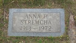
Erna P Nelson Stremcha
| Birth | : | 28 Apr 1913 Havre, Hill County, Montana, USA |
| Death | : | 22 Aug 1972 Wilmington, Los Angeles County, California, USA |
| Burial | : | Highland Cemetery, Havre, Hill County, USA |
| Coordinate | : | 48.5463982, -109.6900024 |
| Plot | : | Space B1/2, Lot 13, Block 22 |
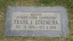
| Description | : | Havre Daily News (MT), 24 Aug 1972 Graveside services will be Tuesday, Aug. 29, at 10 a.m. in Highland cemetery in Havre for Mrs. Erna P. Stremcha, a former Havre resident who died in Wilmington, Calif., Aug 22. Mrs. Stremcha was born in Havre, April 28, 1913. She attended schools here. On Aug. 13, 1929, in Chinook, she married Frank Stremcha and the couple remained in Havre until 1941, when they made their home in Wilmington, Calif. Survivors include a son, Gaylen of Wilmington; two grandchildren; two sisters, Mrs. Albertina Gray and Mrs. Alvina Henry, both of Calif.;... Read More |
frequently asked questions (FAQ):
-
Where is Erna P Nelson Stremcha's memorial?
Erna P Nelson Stremcha's memorial is located at: Highland Cemetery, Havre, Hill County, USA.
-
When did Erna P Nelson Stremcha death?
Erna P Nelson Stremcha death on 22 Aug 1972 in Wilmington, Los Angeles County, California, USA
-
Where are the coordinates of the Erna P Nelson Stremcha's memorial?
Latitude: 48.5463982
Longitude: -109.6900024
Family Members:
Spouse
Children

Flowers:


Nearby Cemetories:
1. Highland Cemetery
Havre, Hill County, USA
Coordinate: 48.5463982, -109.6900024
2. Calvary Cemetery
Havre, Hill County, USA
Coordinate: 48.5457000, -109.6883000
3. Mount Hope Cemetery
Havre, Hill County, USA
Coordinate: 48.5540000, -109.7050000
4. Sunset Garden Park
Havre, Hill County, USA
Coordinate: 48.5531006, -109.8019028
5. North Havre Lutheran Church Graveyard (Defunct)
Havre, Hill County, USA
Coordinate: 48.6538903, -109.6815870
6. Grainbelt Cemetery
Hill County, USA
Coordinate: 48.6828003, -109.8657990
7. Andrew S. Lohman Grave Site
Lohman, Blaine County, USA
Coordinate: 48.5903520, -109.4073350
8. East End Colony Cemetery
East End Colony, Hill County, USA
Coordinate: 48.7485000, -109.5474000
9. Hilldale Hutterite Colony Cemetery
Hilldale Colony, Hill County, USA
Coordinate: 48.7997000, -109.7872000
10. Saint Johns Catholic Cemetery
Havre, Hill County, USA
Coordinate: 48.7625008, -109.9638977
11. Saint Gabriel Cemetery
Chinook, Blaine County, USA
Coordinate: 48.6065200, -109.2531200
12. Kuper Memorial Cemetery
Chinook, Blaine County, USA
Coordinate: 48.6083100, -109.2531200
13. Rocky Boy Cemetery
Rocky Boy, Hill County, USA
Coordinate: 48.2572410, -109.7923690
14. Box Elder Cemetery
Box Elder, Hill County, USA
Coordinate: 48.3274000, -110.0095000
15. Rocky Boy Gravel Cemetery
Rocky Boy, Hill County, USA
Coordinate: 48.2427720, -109.7596500
16. Cottonwood Lutheran Church Cemetery
Havre, Hill County, USA
Coordinate: 48.4545000, -110.1748000
17. Bear Paw Battlefield
Chinook, Blaine County, USA
Coordinate: 48.3780070, -109.2121290
18. Hungry Hollow Cemetery
Blaine County, USA
Coordinate: 48.2103004, -109.4677963
19. Milk River Valley Church Graveyard
Hill County, USA
Coordinate: 48.6787180, -110.2261080
20. Hollandville Cemetery
Chinook, Blaine County, USA
Coordinate: 48.6960310, -109.1557200
21. Gildford Hill County Cemetery
Gildford, Hill County, USA
Coordinate: 48.5778008, -110.2957993
22. Prairie Chapel United Brethren Cemetery
Chinook, Blaine County, USA
Coordinate: 48.8860000, -109.3414000
23. Mennonite Brethren Cemetery
Chinook, Blaine County, USA
Coordinate: 48.8012560, -109.1980620
24. Bethel Bruderthaler Mennonite Church Cemetery
Chinook, Blaine County, USA
Coordinate: 48.7552000, -109.1345000