
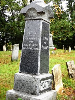

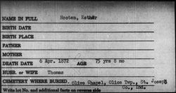
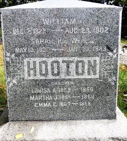
Esther Montgomery Hooton
| Birth | : | 6 Aug 1796 Estill County, Kentucky, USA |
| Death | : | 6 Apr 1872 New Carlisle, St. Joseph County, Indiana, USA |
| Burial | : | Bowe Cemetery, Pea Ridge, Clay County, USA |
| Coordinate | : | 36.5833015, -85.4439011 |
| Inscription | : | ESTHER WIFE OF THOS. HOOTON SEN DIED APR. 6., 1872, AGED 75Y'S, 8MO. _________ |
| Description | : | daughter of James Montgomery and Nancy Ellen Dozier Married August 13, 1815 Clark County, Kentucky |
frequently asked questions (FAQ):
-
Where is Esther Montgomery Hooton's memorial?
Esther Montgomery Hooton's memorial is located at: Bowe Cemetery, Pea Ridge, Clay County, USA.
-
When did Esther Montgomery Hooton death?
Esther Montgomery Hooton death on 6 Apr 1872 in New Carlisle, St. Joseph County, Indiana, USA
-
Where are the coordinates of the Esther Montgomery Hooton's memorial?
Latitude: 36.5833015
Longitude: -85.4439011
Family Members:
Spouse
Children

Flowers:


Nearby Cemetories:
1. Bowe Cemetery
Pea Ridge, Clay County, USA
Coordinate: 36.5833015, -85.4439011
2. Key Cemetery
Pea Ridge, Clay County, USA
Coordinate: 36.5875015, -85.4518967
3. Donaldson Cemetery
Pea Ridge, Clay County, USA
Coordinate: 36.5952988, -85.4424973
4. Ray Williams Cemetery
Pea Ridge, Clay County, USA
Coordinate: 36.5856130, -85.4598120
5. Mullins - Kerr Cemetery
Pea Ridge, Clay County, USA
Coordinate: 36.5951330, -85.4317470
6. Grover Rich Cemetery
Pea Ridge, Clay County, USA
Coordinate: 36.5946370, -85.4602970
7. Crossroads Cemetery
Clay County, USA
Coordinate: 36.6074982, -85.4210968
8. Thompson Webb Cemetery
Celina, Clay County, USA
Coordinate: 36.6090110, -85.4202270
9. Hattie's Houses Cemetery
Pea Ridge, Clay County, USA
Coordinate: 36.6159200, -85.4360040
10. Rock Springs Cemetery
Celina, Clay County, USA
Coordinate: 36.6096992, -85.4167023
11. Thompson Cemetery
Clay County, USA
Coordinate: 36.6123700, -85.4666600
12. Williams Cemetery
Pea Ridge, Clay County, USA
Coordinate: 36.6150017, -85.4169006
13. Page Family Cemetery
Free Hill, Clay County, USA
Coordinate: 36.5623018, -85.4844294
14. Ashlock Cemetery
Ashlock, Cumberland County, USA
Coordinate: 36.6208380, -85.4283620
15. Tinsley Cemetery
Cave Springs, Clay County, USA
Coordinate: 36.5527992, -85.4800034
16. Robert Arms Cemetery
Pea Ridge, Clay County, USA
Coordinate: 36.5432790, -85.4657820
17. Edens-Smith Cemetery
Clay County, USA
Coordinate: 36.5979390, -85.4976300
18. Crawford Cemetery
Celina, Clay County, USA
Coordinate: 36.5979660, -85.4976660
19. Free Hill Cemetery
Clay County, USA
Coordinate: 36.5628014, -85.4955978
20. Short's Chapel Cemetery
Monroe County, USA
Coordinate: 36.6281013, -85.4589005
21. Buford Cemetery
Clay County, USA
Coordinate: 36.5405998, -85.4139023
22. Killman Cemetery
Ashlock, Cumberland County, USA
Coordinate: 36.6325850, -85.4256430
23. Walker Cemetery
Celina, Clay County, USA
Coordinate: 36.5372009, -85.4728012
24. Fitzgerald Cemetery
Celina, Clay County, USA
Coordinate: 36.5518990, -85.4966965