
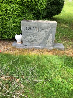
| Birth | : | 17 May 1937 Carroll County, Virginia, USA |
| Death | : | 7 Oct 2012 Mount Airy, Surry County, North Carolina, USA |
| Burial | : | Zion Hill Primitive Baptist Church Cemetery, Crooked Oak, Surry County, USA |
| Coordinate | : | 36.5313339, -80.7572250 |
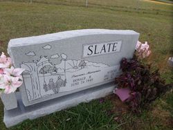
| Description | : | Mrs. Ethel Louise Slate, 75, of Mt. Airy passed away Sunday, October 7, 2012 at her home. She was born in Carroll County on May 17, 1937 to the late Tom and Nancy Dean Gwyn. Mrs. Slate is survived by her husband, Johnny Slate of the home; a daughter, Toni Slate Mitchell of Mt. Airy; a son, Donald Ray Robinson of Mt. Airy; six grandchildren; one great grandchild; sisters, Audene Slate and Julie Hicks both of Mt. Airy; brothers, Larry Gwyn of Mt. Airy, and Dennis Gwyn of Fancy Gap, VA. In addition to her parents, Mrs. Slate was preceded... Read More |
frequently asked questions (FAQ):
-
Where is Ethel Louise Gwyn Slate's memorial?
Ethel Louise Gwyn Slate's memorial is located at: Zion Hill Primitive Baptist Church Cemetery, Crooked Oak, Surry County, USA.
-
When did Ethel Louise Gwyn Slate death?
Ethel Louise Gwyn Slate death on 7 Oct 2012 in Mount Airy, Surry County, North Carolina, USA
-
Where are the coordinates of the Ethel Louise Gwyn Slate's memorial?
Latitude: 36.5313339
Longitude: -80.7572250
Family Members:
Parent

Spouse
Siblings

Flowers:


Nearby Cemetories:
1. Zion Hill Primitive Baptist Church Cemetery
Crooked Oak, Surry County, USA
Coordinate: 36.5313339, -80.7572250
2. Golding Family Cemetery
Mount Airy, Surry County, USA
Coordinate: 36.5326670, -80.7528330
3. Johnson Puckett Cemetery
Mount Airy, Surry County, USA
Coordinate: 36.5306740, -80.7362830
4. Ivy Green Baptist Church Cemetery
Crooked Oak, Surry County, USA
Coordinate: 36.5381927, -80.7771683
5. Jarrell Family Graveyard
Lowgap, Surry County, USA
Coordinate: 36.5362520, -80.7798310
6. Furbee Cemetery
Wetzel County, USA
Coordinate: 36.5363984, -80.7316687
7. Blue Ridge Baptist Church Cemetery
Crooked Oak, Surry County, USA
Coordinate: 36.5490440, -80.7727400
8. Snow Cemetery
Mount Airy, Surry County, USA
Coordinate: 36.5422500, -80.7299170
9. Holder Cemetery
Lowgap, Surry County, USA
Coordinate: 36.5364670, -80.7875720
10. Round Peak Primitive Baptist Church Cemetery
Round Peak, Surry County, USA
Coordinate: 36.5145264, -80.7861633
11. Phillip Haywood McBride Family Cemetery
Lowgap, Surry County, USA
Coordinate: 36.5602950, -80.7678630
12. Maple Grove United Methodist Church Cemetery
Pine Ridge, Surry County, USA
Coordinate: 36.5237770, -80.7171402
13. Imogene Baptist Church Cemetery
Pine Ridge, Surry County, USA
Coordinate: 36.5521393, -80.7203598
14. Low Family Cemetery
Lowgap, Surry County, USA
Coordinate: 36.5461430, -80.7985910
15. Dillard Family Cemetery
Lowgap, Surry County, USA
Coordinate: 36.5500298, -80.8002243
16. Semper Fi Cemetery
Pine Ridge, Surry County, USA
Coordinate: 36.5010540, -80.7216920
17. Moore Family Cemetery
Mount Airy, Surry County, USA
Coordinate: 36.4919910, -80.7741450
18. Stewart Cemetery
Lambsburg, Carroll County, USA
Coordinate: 36.5681860, -80.7855490
19. Pine Ridge Baptist Church Cemetery
Pine Ridge, Surry County, USA
Coordinate: 36.4995842, -80.7190552
20. Jarrell Family Cemetery
Lowgap, Surry County, USA
Coordinate: 36.5427860, -80.8103660
21. Holly Grove Baptist Church Cemetery
Lambsburg, Carroll County, USA
Coordinate: 36.5712840, -80.7810790
22. Beamer Cemetery
Mount Airy, Surry County, USA
Coordinate: 36.5343060, -80.7012220
23. Payne Cemetery
Lowgap, Surry County, USA
Coordinate: 36.4947220, -80.7928060
24. Edwards-Upchurch Cemetery
Lambsburg, Carroll County, USA
Coordinate: 36.5750140, -80.7788060