
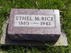
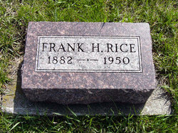
Ethel May Feuring Rice
| Birth | : | 14 Dec 1880 Illinois, USA |
| Death | : | 1942 Adair County, Iowa, USA |
| Burial | : | White Ridge Cemetery, Eatontown, Monmouth County, USA |
| Coordinate | : | 40.2863998, -74.0496979 |
| Plot | : | lot 59 old third addition |
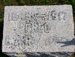
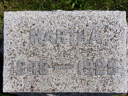
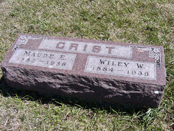
| Description | : | Daughter of Frederick Christopher & Martha Ellen Averill Feuring. Married to: 1) William Wiley Crist 2) Frank H. Rice |
frequently asked questions (FAQ):
-
Where is Ethel May Feuring Rice's memorial?
Ethel May Feuring Rice's memorial is located at: White Ridge Cemetery, Eatontown, Monmouth County, USA.
-
When did Ethel May Feuring Rice death?
Ethel May Feuring Rice death on 1942 in Adair County, Iowa, USA
-
Where are the coordinates of the Ethel May Feuring Rice's memorial?
Latitude: 40.2863998
Longitude: -74.0496979
Family Members:
Parent
Spouse
Siblings

Children
Flowers:


Nearby Cemetories:
1. White Ridge Cemetery
Eatontown, Monmouth County, USA
Coordinate: 40.2863998, -74.0496979
2. Locust Grove Cemetery
Eatontown, Monmouth County, USA
Coordinate: 40.2924309, -74.0535431
3. Fields Cemetery
Eatontown, Monmouth County, USA
Coordinate: 40.2849998, -74.0736008
4. Glenwood Cemetery
West Long Branch, Monmouth County, USA
Coordinate: 40.2947006, -74.0269012
5. Woodbine Cemetery and Mausoleum
Oceanport, Monmouth County, USA
Coordinate: 40.3011017, -74.0294037
6. Old First Methodist Church Cemetery
West Long Branch, Monmouth County, USA
Coordinate: 40.2847214, -74.0178452
7. Old Free Church Cemetery
West Long Branch, Monmouth County, USA
Coordinate: 40.2770844, -74.0177765
8. Congregation Brothers of Israel Cemetery Annex
West Long Branch, Monmouth County, USA
Coordinate: 40.3009033, -74.0190964
9. Greenlawn Cemetery
West Long Branch, Monmouth County, USA
Coordinate: 40.2988892, -74.0143738
10. Monmouth Fields Cemetery
West Long Branch, Monmouth County, USA
Coordinate: 40.2989200, -74.0143900
11. Mount Carmel Cemetery
West Long Branch, Monmouth County, USA
Coordinate: 40.2891998, -74.0102997
12. Wayside United Methodist Cemetery
Oakhurst, Monmouth County, USA
Coordinate: 40.2600300, -74.0695000
13. Congregation Brothers Of Israel Cemetery
West Long Branch, Monmouth County, USA
Coordinate: 40.2998619, -74.0133362
14. Slocum Family Burying Ground
Long Branch, Monmouth County, USA
Coordinate: 40.2997700, -74.0127700
15. Christ Church Episcopal Graveyard
Shrewsbury, Monmouth County, USA
Coordinate: 40.3236122, -74.0613174
16. First Presbyterian Churchyard
Shrewsbury, Monmouth County, USA
Coordinate: 40.3240280, -74.0604477
17. Friends Meeting House Burial Ground
Shrewsbury, Monmouth County, USA
Coordinate: 40.3244438, -74.0611115
18. Pine Brook Cemetery
Macedonia, Monmouth County, USA
Coordinate: 40.2801590, -74.1058655
19. Ruffin Cemetery
Macedonia, Monmouth County, USA
Coordinate: 40.2803030, -74.1068820
20. Shadow Rest Cemetery
Macedonia, Monmouth County, USA
Coordinate: 40.2805320, -74.1071820
21. Drummond Cemetery
Wanamassa, Monmouth County, USA
Coordinate: 40.2459300, -74.0212800
22. Saint Johns Memorial Garden
Little Silver, Monmouth County, USA
Coordinate: 40.3339091, -74.0326643
23. Enslaved Black Burial Ground
Tinton Falls, Monmouth County, USA
Coordinate: 40.3175614, -74.1049500
24. Evergreen Cemetery
Little Silver, Monmouth County, USA
Coordinate: 40.3410492, -74.0413208