
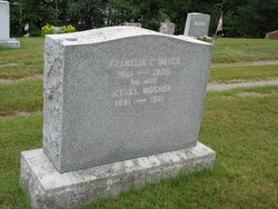
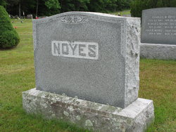
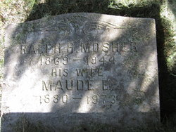
Ethel Mosher Noyes
| Birth | : | 18 Aug 1881 China, Kennebec County, Maine, USA |
| Death | : | 10 Jan 1961 Wilton, Franklin County, Maine, USA |
| Burial | : | Bollinger County Memorial Park Cemetery, Marble Hill, Bollinger County, USA |
| Coordinate | : | 37.2689018, -89.9871979 |
| Description | : | 1930 Census: Head Franklin F Noyes M 68 Maine Wife Ethel M Noyes F 48 Maine Son Carleton F Noyes M 19 Maine Niece Helen M Noyes F 35 Maine |
frequently asked questions (FAQ):
-
Where is Ethel Mosher Noyes's memorial?
Ethel Mosher Noyes's memorial is located at: Bollinger County Memorial Park Cemetery, Marble Hill, Bollinger County, USA.
-
When did Ethel Mosher Noyes death?
Ethel Mosher Noyes death on 10 Jan 1961 in Wilton, Franklin County, Maine, USA
-
Where are the coordinates of the Ethel Mosher Noyes's memorial?
Latitude: 37.2689018
Longitude: -89.9871979
Family Members:
Parent

Spouse
Siblings
Children
Flowers:


Nearby Cemetories:
1. Bollinger County Memorial Park Cemetery
Marble Hill, Bollinger County, USA
Coordinate: 37.2689018, -89.9871979
2. Baker Cemetery
Marble Hill, Bollinger County, USA
Coordinate: 37.2722015, -89.9869003
3. Shell Cemetery
Lutesville, Bollinger County, USA
Coordinate: 37.2839012, -89.9693985
4. Hahn Cemetery
Lutesville, Bollinger County, USA
Coordinate: 37.2886009, -89.9772034
5. Patterson Family Cemetery
Bollinger County, USA
Coordinate: 37.2511100, -90.0107100
6. Slaybaugh Cemetery
Lutesville, Bollinger County, USA
Coordinate: 37.2982150, -89.9851870
7. Eaker Cemetery
Lutesville, Bollinger County, USA
Coordinate: 37.2778015, -89.9516983
8. Dry Creek Cemetery
Lutesville, Bollinger County, USA
Coordinate: 37.2675018, -90.0291977
9. Marble Hill Cemetery
Marble Hill, Bollinger County, USA
Coordinate: 37.3032799, -89.9701309
10. El Nathan Cemetery
Marble Hill, Bollinger County, USA
Coordinate: 37.3086710, -89.9757960
11. Clubb Creek Church Cemetery
Trowel, Bollinger County, USA
Coordinate: 37.2318306, -90.0125275
12. Lower Deck Cemetery
Lutesville, Bollinger County, USA
Coordinate: 37.3078003, -90.0119019
13. Crites Cemetery
Trowel, Bollinger County, USA
Coordinate: 37.2318993, -90.0164032
14. Perkins Cemetery
Bollinger County, USA
Coordinate: 37.2738991, -89.9313965
15. Hahn Chapel Cemetery
Marble Hill, Bollinger County, USA
Coordinate: 37.3061638, -89.9492645
16. Saint Johns Cemetery
Leopold, Bollinger County, USA
Coordinate: 37.2585983, -89.9282990
17. Shelton Cemetery
Huxie, Bollinger County, USA
Coordinate: 37.2556000, -90.0481033
18. Myers Cemetery
Glenallen, Bollinger County, USA
Coordinate: 37.3171997, -90.0096970
19. Cane Creek Cemetery
Huxie, Bollinger County, USA
Coordinate: 37.2468987, -90.0485992
20. James Cemetery
Bollinger County, USA
Coordinate: 37.2346600, -90.0478900
21. Glen Allen Cemetery
Glenallen, Bollinger County, USA
Coordinate: 37.3201100, -90.0320100
22. Upper Deck Cemetery
Glenallen, Bollinger County, USA
Coordinate: 37.3236008, -90.0444031
23. Formway Cemetery
Bollinger County, USA
Coordinate: 37.3166900, -89.9165400
24. Myers Cemetery
Huxie, Bollinger County, USA
Coordinate: 37.2677994, -90.0839005