
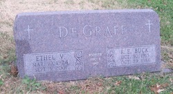
Ethel Vivian Vering Markley-DeGraff
| Birth | : | 10 Mar 1924 Marysville, Marshall County, Kansas, USA |
| Death | : | 1 Sep 2001 Lawrence, Douglas County, Kansas, USA |
| Burial | : | Mount Calvary Catholic Cemetery, Lawrence, Douglas County, USA |
| Coordinate | : | 38.9580002, -95.2139969 |
| Description | : | Services for Ethel Markley DeGraff, 77, Lawrence, will be 11 a.m. Wednesday at St. John the Evangelist Catholic Church. Burial will be in Mt. Calvary Catholic Cemetery. Mrs. DeGraff died Saturday, Sept. 1, 2001, at Lawrence Memorial Hospital. She was born March 10, 1924, in Marysville, the daughter of John A. and Johanna A. (Wassenberg) Vering. She graduated from Marysville High School in 1941 and attended Kansas University. Mrs. DeGraff worked 31 years as a secretary at Central Junior High School and retired on June 30, 1994. She was a member of St. John the Evangelist Church, where she was a member of... Read More |
frequently asked questions (FAQ):
-
Where is Ethel Vivian Vering Markley-DeGraff's memorial?
Ethel Vivian Vering Markley-DeGraff's memorial is located at: Mount Calvary Catholic Cemetery, Lawrence, Douglas County, USA.
-
When did Ethel Vivian Vering Markley-DeGraff death?
Ethel Vivian Vering Markley-DeGraff death on 1 Sep 2001 in Lawrence, Douglas County, Kansas, USA
-
Where are the coordinates of the Ethel Vivian Vering Markley-DeGraff's memorial?
Latitude: 38.9580002
Longitude: -95.2139969
Family Members:
Parent

Spouse

Siblings
Children
Flowers:


Nearby Cemetories:
1. Mount Calvary Catholic Cemetery
Lawrence, Douglas County, USA
Coordinate: 38.9580002, -95.2139969
2. Oak Hill Cemetery
Lawrence, Douglas County, USA
Coordinate: 38.9589005, -95.2118988
3. Memorial Park Cemetery
Lawrence, Douglas County, USA
Coordinate: 38.9552994, -95.2153015
4. Trinity Episcopal Church Columbarium
Lawrence, Douglas County, USA
Coordinate: 38.9653893, -95.2373886
5. Saint Johns Catholic Cemetery
Douglas County, USA
Coordinate: 38.9437900, -95.1919600
6. Dyche Hall Natural History Museum
Lawrence, Douglas County, USA
Coordinate: 38.9584800, -95.2434800
7. Haskell Cemetery
Lawrence, Douglas County, USA
Coordinate: 38.9353790, -95.2284241
8. Franklin Cemetery
Douglas County, USA
Coordinate: 38.9437523, -95.1869431
9. Pioneer Cemetery
Lawrence, Douglas County, USA
Coordinate: 38.9528008, -95.2611008
10. First Presbyterian Church Memorial Garden
Lawrence, Douglas County, USA
Coordinate: 38.9414900, -95.2641600
11. Maple Grove Cemetery
Lawrence, Douglas County, USA
Coordinate: 39.0018997, -95.2316971
12. County Poor Farm Cemetery
Douglas County, USA
Coordinate: 38.9119400, -95.2214600
13. Adams Cemetery
Douglas County, USA
Coordinate: 38.9955400, -95.2509100
14. Kennedy Cemetery
Douglas County, USA
Coordinate: 38.9112900, -95.2269200
15. Davis Cemetery
Lawrence, Douglas County, USA
Coordinate: 38.9722500, -95.2831100
16. Blue Mound Cemetery
Lawrence, Douglas County, USA
Coordinate: 38.9046600, -95.1865400
17. Marshall Cemetery
Douglas County, USA
Coordinate: 38.9040800, -95.2446700
18. Dutton Cemetery
Douglas County, USA
Coordinate: 38.8989800, -95.2790600
19. Luckan Family Cemetery
Fall Leaf, Leavenworth County, USA
Coordinate: 38.9808500, -95.1128000
20. Cemetery Beni Israel
Eudora, Douglas County, USA
Coordinate: 38.9280128, -95.1122208
21. Lyon Family Cemetery
Lawrence, Douglas County, USA
Coordinate: 38.9877440, -95.3166530
22. Corpus Christi Catholic Church Columbarium
Lawrence, Douglas County, USA
Coordinate: 38.9572250, -95.3238450
23. Southwest City Cemetery
Eudora, Douglas County, USA
Coordinate: 38.9334800, -95.1070300
24. Richland Cemetery
Lawrence, Douglas County, USA
Coordinate: 38.8768997, -95.2630997