
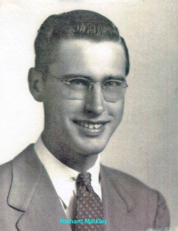


Pvt Richard Leland “Dick” Markley
| Birth | : | 25 Jun 1923 Douglas County, Kansas, USA |
| Death | : | 24 Jan 1957 Hobbs, Lea County, New Mexico, USA |
| Burial | : | Mount Calvary Catholic Cemetery, Lawrence, Douglas County, USA |
| Coordinate | : | 38.9580002, -95.2139969 |
| Inscription | : | Kansas Pvt 1753 Service Unit WWII |
| Description | : | The sudden death of Richard Leland Markley on January 24, 1957 in Hobbs, NM came as a shock to his many friends in the petroleum industry, and caused an untimely loss of one of the Roswell Geological Society's outstanding members. Dick Markley was born June 25, 1923 at Lawrence, KS. He entered the University of Kansas in 1941, and after time out to serve with distinction in the US Army, received his Bachelor of Science degree in geology in 1947. While attending the University, he defrayed part of his education expenses by working for the Kansas State Geological Society.... Read More |
frequently asked questions (FAQ):
-
Where is Pvt Richard Leland “Dick” Markley's memorial?
Pvt Richard Leland “Dick” Markley's memorial is located at: Mount Calvary Catholic Cemetery, Lawrence, Douglas County, USA.
-
When did Pvt Richard Leland “Dick” Markley death?
Pvt Richard Leland “Dick” Markley death on 24 Jan 1957 in Hobbs, Lea County, New Mexico, USA
-
Where are the coordinates of the Pvt Richard Leland “Dick” Markley's memorial?
Latitude: 38.9580002
Longitude: -95.2139969
Family Members:

Spouse
Siblings
Children
Flowers:


Nearby Cemetories:
1. Mount Calvary Catholic Cemetery
Lawrence, Douglas County, USA
Coordinate: 38.9580002, -95.2139969
2. Oak Hill Cemetery
Lawrence, Douglas County, USA
Coordinate: 38.9589005, -95.2118988
3. Memorial Park Cemetery
Lawrence, Douglas County, USA
Coordinate: 38.9552994, -95.2153015
4. Trinity Episcopal Church Columbarium
Lawrence, Douglas County, USA
Coordinate: 38.9653893, -95.2373886
5. Saint Johns Catholic Cemetery
Douglas County, USA
Coordinate: 38.9437900, -95.1919600
6. Dyche Hall Natural History Museum
Lawrence, Douglas County, USA
Coordinate: 38.9584800, -95.2434800
7. Haskell Cemetery
Lawrence, Douglas County, USA
Coordinate: 38.9353790, -95.2284241
8. Franklin Cemetery
Douglas County, USA
Coordinate: 38.9437523, -95.1869431
9. Pioneer Cemetery
Lawrence, Douglas County, USA
Coordinate: 38.9528008, -95.2611008
10. First Presbyterian Church Memorial Garden
Lawrence, Douglas County, USA
Coordinate: 38.9414900, -95.2641600
11. Maple Grove Cemetery
Lawrence, Douglas County, USA
Coordinate: 39.0018997, -95.2316971
12. County Poor Farm Cemetery
Douglas County, USA
Coordinate: 38.9119400, -95.2214600
13. Adams Cemetery
Douglas County, USA
Coordinate: 38.9955400, -95.2509100
14. Kennedy Cemetery
Douglas County, USA
Coordinate: 38.9112900, -95.2269200
15. Davis Cemetery
Lawrence, Douglas County, USA
Coordinate: 38.9722500, -95.2831100
16. Blue Mound Cemetery
Lawrence, Douglas County, USA
Coordinate: 38.9046600, -95.1865400
17. Marshall Cemetery
Douglas County, USA
Coordinate: 38.9040800, -95.2446700
18. Dutton Cemetery
Douglas County, USA
Coordinate: 38.8989800, -95.2790600
19. Luckan Family Cemetery
Fall Leaf, Leavenworth County, USA
Coordinate: 38.9808500, -95.1128000
20. Cemetery Beni Israel
Eudora, Douglas County, USA
Coordinate: 38.9280128, -95.1122208
21. Lyon Family Cemetery
Lawrence, Douglas County, USA
Coordinate: 38.9877440, -95.3166530
22. Corpus Christi Catholic Church Columbarium
Lawrence, Douglas County, USA
Coordinate: 38.9572250, -95.3238450
23. Southwest City Cemetery
Eudora, Douglas County, USA
Coordinate: 38.9334800, -95.1070300
24. Richland Cemetery
Lawrence, Douglas County, USA
Coordinate: 38.8768997, -95.2630997