
| Birth | : | 1914 Leatherbark, Calhoun County, West Virginia, USA |
| Death | : | 5 Apr 2001 Orma, Calhoun County, West Virginia, USA |
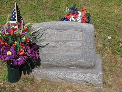
| Burial | : | Fort Bayard National Cemetery, Fort Bayard, Grant County, USA |
| Coordinate | : | 32.7989006, -108.1541977 |
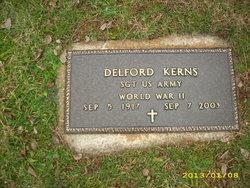
| Description | : | Hur Herald - (04/08/2001) Eula Houchin Hall Kerns, 87 of Orma, Calhoun County, died April 5, 2001 at her home following a long illness. Born at Leatherbark, she was a daughter of the late Grover and Stella Matheney Houchin. She was active all her life having operated a service station and store in Spencer with her first husband, the late Doy Hall. She was also employed by Kellwood. She was a member of the Beech United Methodist Church. Surviving, husband Delcord Kerns; sons, Donzil R. Hall of St. Paris, Ohio, Paul E. Hall of Alliance, Ohio and Darius W. Hall of Wooster,... Read More |
frequently asked questions (FAQ):
-
Where is Eula Houchin-Hall Kerns's memorial?
Eula Houchin-Hall Kerns's memorial is located at: Fort Bayard National Cemetery, Fort Bayard, Grant County, USA.
-
When did Eula Houchin-Hall Kerns death?
Eula Houchin-Hall Kerns death on 5 Apr 2001 in Orma, Calhoun County, West Virginia, USA
-
Where are the coordinates of the Eula Houchin-Hall Kerns's memorial?
Latitude: 32.7989006
Longitude: -108.1541977
Family Members:
Parent

Spouse
Siblings
Flowers:


Nearby Cemetories:
1. Fort Bayard Memorial Cemetery
Fort Bayard, Grant County, USA
Coordinate: 32.7907000, -108.1565000
2. Santa Clara Cemetery
Central, Grant County, USA
Coordinate: 32.7701920, -108.1530590
3. Vanadium Cemetery
Vanadium, Grant County, USA
Coordinate: 32.7820000, -108.1100000
4. Hanover Cemetery
Hanover, Grant County, USA
Coordinate: 32.8063000, -108.0893000
5. Bayard Cemetery
Bayard, Grant County, USA
Coordinate: 32.7403620, -108.1326270
6. Fierro Cemetery
Fierro, Grant County, USA
Coordinate: 32.8436012, -108.0755997
7. Santa Rita Cemetery #4
Santa Rita, Grant County, USA
Coordinate: 32.8137200, -108.0576200
8. Santa Rita #4
Santa Rita (Noriega y Anexo), Santa Bárbara Municipality, Mexico
Coordinate: 32.8136425, -108.0571579
9. Pinos Altos Community Cemetery
Pinos Altos, Grant County, USA
Coordinate: 32.8672791, -108.2173004
10. Memory Lane Cemetery
Silver City, Grant County, USA
Coordinate: 32.7830000, -108.2570000
11. Hurley Cemetery
Hurley, Grant County, USA
Coordinate: 32.6885986, -108.1363983
12. Masonic Cemetery
Silver City, Grant County, USA
Coordinate: 32.7572972, -108.2812361
13. Saint Vincent de Paul Catholic Cemetery
Silver City, Grant County, USA
Coordinate: 32.7572861, -108.2812361
14. Georgetown Cemetery
Silver City, Grant County, USA
Coordinate: 32.8405991, -108.0147018
15. Peace of the Wilderness Cemetery
Silver City, Grant County, USA
Coordinate: 32.8682050, -108.2875500
16. Hicks Cemetery
Grant County, USA
Coordinate: 32.9103012, -108.0044022
17. San Lorenzo Cemetery
San Lorenzo, Grant County, USA
Coordinate: 32.7910270, -107.9205040
18. San Juan Catholic Cemetery
Grant County, USA
Coordinate: 32.7647705, -107.9098969
19. Pine Cienega Cemetery
Grant County, USA
Coordinate: 32.6226050, -108.3039090
20. Perrault Ranch Cemetery
Sherman, Grant County, USA
Coordinate: 32.7493770, -107.8935000
21. Savannah Cemetery
Tyrone, Grant County, USA
Coordinate: 32.6443000, -108.3568000
22. Coleson's Crossing Cemetery
Dwyer, Grant County, USA
Coordinate: 32.5682540, -107.9522090
23. Dwyer Cemetery
Dwyer, Grant County, USA
Coordinate: 32.6231600, -107.8792400
24. Foster Cemetery
Luna County, USA
Coordinate: 32.5862410, -107.9062660