
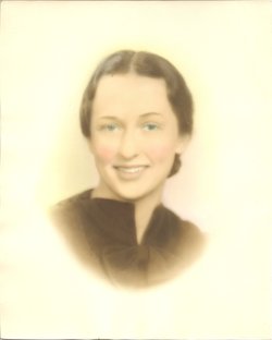
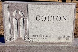
Eunice Marjorie “Marjorie” Moore Colton
| Birth | : | 7 Dec 1916 Isabel, Barber County, Kansas, USA |
| Death | : | 7 Nov 2011 Kansas City, Jackson County, Missouri, USA |
| Burial | : | Saint Marys Catholic Cemetery, Glasco, Cloud County, USA |
| Coordinate | : | 39.3574000, -97.8245000 |
| Plot | : | 4CW1 |
| Description | : | Marjorie Colton, 94 years 11 months, died Monday, November 7, 2011, in Kansas City, Missouri. She was preceded in death by her husband, both her parents, as well as 4 brothers and her only sister. Blessed at her passing, as she was in her full life, she received the Anointing of the Sick and slipped away peacefully with her son and family at her bedside, her rosary in one hand and a prayer card in the other. Mrs. Colton was born December 7, 1916, in Isabel, KS. She attended high school in Hornick, Iowa, and started college at Kansas State... Read More |
frequently asked questions (FAQ):
-
Where is Eunice Marjorie “Marjorie” Moore Colton's memorial?
Eunice Marjorie “Marjorie” Moore Colton's memorial is located at: Saint Marys Catholic Cemetery, Glasco, Cloud County, USA.
-
When did Eunice Marjorie “Marjorie” Moore Colton death?
Eunice Marjorie “Marjorie” Moore Colton death on 7 Nov 2011 in Kansas City, Jackson County, Missouri, USA
-
Where are the coordinates of the Eunice Marjorie “Marjorie” Moore Colton's memorial?
Latitude: 39.3574000
Longitude: -97.8245000
Family Members:
Flowers:


Nearby Cemetories:
1. Saint Marys Catholic Cemetery
Glasco, Cloud County, USA
Coordinate: 39.3574000, -97.8245000
2. Glasco Cemetery
Glasco, Cloud County, USA
Coordinate: 39.3574000, -97.8265000
3. Bethel Cemetery
Meredith Township, Cloud County, USA
Coordinate: 39.3506000, -97.7029000
4. Simpson Cemetery
Simpson, Mitchell County, USA
Coordinate: 39.3633003, -97.9471970
5. Delphos Cemetery
Delphos, Ottawa County, USA
Coordinate: 39.2778015, -97.7416992
6. Saint Paul Cemetery
Delphos, Ottawa County, USA
Coordinate: 39.2677994, -97.7518997
7. Morrison Cemetery
Center Township, Cloud County, USA
Coordinate: 39.4817009, -97.7975006
8. Asherville Cemetery
Asherville, Mitchell County, USA
Coordinate: 39.4205000, -97.9672900
9. Summit Cemetery
Jamestown, Cloud County, USA
Coordinate: 39.4813200, -97.8628800
10. Hall Cemetery
Cloud County, USA
Coordinate: 39.4455986, -97.7033005
11. Green Mound Cemetery
Asherville, Mitchell County, USA
Coordinate: 39.3203011, -97.9858017
12. Coursen Grove Cemetery
Simpson, Mitchell County, USA
Coordinate: 39.3060989, -97.9792023
13. Saint Peters Cemetery
Miltonvale, Cloud County, USA
Coordinate: 39.3652350, -97.6483570
14. Bell-Bogardus Cemetery
Asherville, Mitchell County, USA
Coordinate: 39.4242410, -97.9919970
15. Bohemian National Cemetery
Ada, Ottawa County, USA
Coordinate: 39.2193870, -97.9054030
16. Wilcox Cemetery
Cloud County, USA
Coordinate: 39.4925003, -97.7313995
17. West Asher Cemetery
Scottsville, Mitchell County, USA
Coordinate: 39.4815000, -97.9661600
18. Baldwin Cemetery
Ottawa County, USA
Coordinate: 39.2061005, -97.9111023
19. Kindel Cemetery
Center Township, Cloud County, USA
Coordinate: 39.4519005, -97.6464005
20. Smith Cemetery
Asherville, Mitchell County, USA
Coordinate: 39.4516690, -98.0098850
21. Enterprise Cemetery
Cloud County, USA
Coordinate: 39.4230995, -97.6106033
22. McBride Cemetery
Beloit, Mitchell County, USA
Coordinate: 39.4808006, -97.9907990
23. Shiloh Cemetery
Beloit, Mitchell County, USA
Coordinate: 39.3574982, -98.0594025
24. Summit Cemetery #3
Macyville, Cloud County, USA
Coordinate: 39.5258330, -97.9194440