
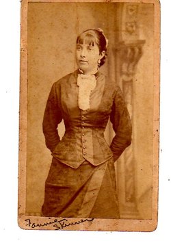
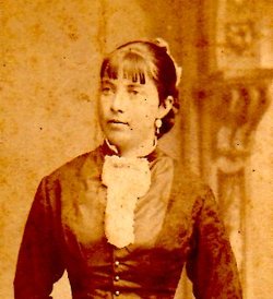

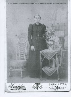
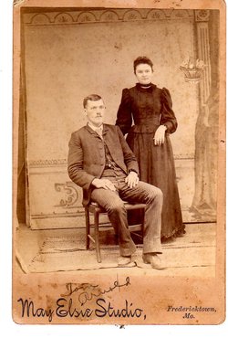
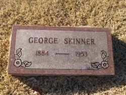
Fannie Arnold Skinner
| Birth | : | 2 Feb 1862 Dent County, Missouri, USA |
| Death | : | 4 Feb 1942 Farmington, St. Francois County, Missouri, USA |
| Burial | : | Saints Peter and Paul Byzantine Cemetery, Punxsutawney, Jefferson County, USA |
| Coordinate | : | 40.9750000, -78.9706000 |
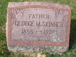
| Description | : | Daughter of John and Sarah (Eaves) Arnold. Married Geeorge M. Skinner Nov 6, 1882. 8 children |
frequently asked questions (FAQ):
-
Where is Fannie Arnold Skinner's memorial?
Fannie Arnold Skinner's memorial is located at: Saints Peter and Paul Byzantine Cemetery, Punxsutawney, Jefferson County, USA.
-
When did Fannie Arnold Skinner death?
Fannie Arnold Skinner death on 4 Feb 1942 in Farmington, St. Francois County, Missouri, USA
-
Where are the coordinates of the Fannie Arnold Skinner's memorial?
Latitude: 40.9750000
Longitude: -78.9706000
Family Members:
Parent
Spouse
Siblings
Children
Flowers:


Nearby Cemetories:
1. Saints Peter and Paul Byzantine Cemetery
Punxsutawney, Jefferson County, USA
Coordinate: 40.9750000, -78.9706000
2. Anita Community Cemetery
Anita, Jefferson County, USA
Coordinate: 40.9932450, -78.9790390
3. Adrian-Anita Roman Catholic Cemetery
Anita, Jefferson County, USA
Coordinate: 40.9958000, -78.9805984
4. Anita Cemetery
Anita, Jefferson County, USA
Coordinate: 40.9972500, -78.9770700
5. Saint Peters Reformed Cemetery
Punxsutawney, Jefferson County, USA
Coordinate: 40.9515150, -78.9616910
6. North Findley Street Cemetery
Punxsutawney, Jefferson County, USA
Coordinate: 40.9466000, -78.9724000
7. Ridgemount Cemetery
Punxsutawney, Jefferson County, USA
Coordinate: 40.9719009, -78.9317017
8. Circle Hill Cemetery
Punxsutawney, Jefferson County, USA
Coordinate: 40.9486008, -78.9496994
9. Clayville Cemetery
Punxsutawney, Jefferson County, USA
Coordinate: 40.9470000, -78.9880000
10. Mount Tabor United Methodist Church Cemetery
Battle Hollow, Jefferson County, USA
Coordinate: 41.0030000, -78.9970000
11. Mount Zion Memorial Cemetery
Jefferson County, USA
Coordinate: 40.9794000, -78.9254000
12. Calvary Cemetery
Punxsutawney, Jefferson County, USA
Coordinate: 40.9358215, -78.9930725
13. Olive Cemetery
Oliveburg, Jefferson County, USA
Coordinate: 40.9940000, -79.0270000
14. Horatio Cemetery
Punxsutawney, Jefferson County, USA
Coordinate: 40.9392000, -79.0133000
15. Pifer Cemetery
Jefferson County, USA
Coordinate: 41.0068000, -78.9210000
16. Zion Presbyterian Cemetery
Panic, Jefferson County, USA
Coordinate: 41.0244300, -78.9530800
17. Oak Lawn Cemetery
Cloe, Jefferson County, USA
Coordinate: 40.9300003, -78.9356003
18. Cherva Agudath Achuin Hebrew Cemetery
Cloe, Jefferson County, USA
Coordinate: 40.9293210, -78.9359090
19. Hopewell United Methodist Church Cemetery
Frostburg, Jefferson County, USA
Coordinate: 40.9620000, -79.0393000
20. Saints Peter And Paul Byzantine Catholic Cemetery
Horatio, Jefferson County, USA
Coordinate: 40.9324989, -79.0180969
21. United Brethren Cemetery
Panic, Jefferson County, USA
Coordinate: 41.0362816, -78.9549637
22. Perry Memorial Cemetery
Frostburg, Jefferson County, USA
Coordinate: 40.9599991, -79.0635986
23. McClure Cemetery
Big Run, Jefferson County, USA
Coordinate: 40.9706100, -78.8750300
24. Fairview Cemetery
Big Run, Jefferson County, USA
Coordinate: 40.9740300, -78.8728300