
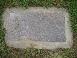
Fern Elizabeth Rieck Hillman
| Birth | : | 30 Mar 1915 Primrose, Boone County, Nebraska, USA |
| Death | : | 5 Oct 2002 Woodland, Cowlitz County, Washington, USA |
| Burial | : | Carlton Cemetery, Nottingham, Nottingham Unitary Authority, England |
| Coordinate | : | 52.9682820, -1.0900230 |
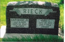
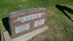
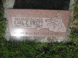
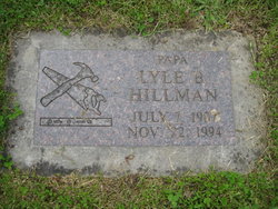
| Description | : | Fern Elizabeth Hillman, 87, of Woodland, Washington died October 5, 2002. She was born March 31, 1915 in Primrose, Nebraska, to Max and Gertrude Rieck. She grew up in Spaulding, Nebraska, and moved to Woodland, Washington 57 years ago from Napa, California. She married Earl Swett in Nebraska in 1934. She later married Lyle Hillman in Washington State in 1959. Mrs. Hillman was a devoted to her family, and enjoyed working with flowers and in her garden. She was a member of the Highland Lutheran Church in LaCenter, WAshington. She is survived by a son, Gene Swett of Warden, Washingon; a daughter,... Read More |
frequently asked questions (FAQ):
-
Where is Fern Elizabeth Rieck Hillman's memorial?
Fern Elizabeth Rieck Hillman's memorial is located at: Carlton Cemetery, Nottingham, Nottingham Unitary Authority, England.
-
When did Fern Elizabeth Rieck Hillman death?
Fern Elizabeth Rieck Hillman death on 5 Oct 2002 in Woodland, Cowlitz County, Washington, USA
-
Where are the coordinates of the Fern Elizabeth Rieck Hillman's memorial?
Latitude: 52.9682820
Longitude: -1.0900230
Family Members:
Parent
Spouse
Siblings

Flowers:


Nearby Cemetories:
1. Carlton Cemetery
Nottingham, Nottingham Unitary Authority, England
Coordinate: 52.9682820, -1.0900230
2. All Hallows Churchyard
Gedling, Gedling Borough, England
Coordinate: 52.9769400, -1.0805130
3. Gedling Cemetery
Gedling, Gedling Borough, England
Coordinate: 52.9806930, -1.0870670
4. St. Paul's Churchyard
Nottingham Unitary Authority, England
Coordinate: 52.9667590, -1.1172140
5. St. Luke's Churchyard
Stoke Bardolph, Gedling Borough, England
Coordinate: 52.9659896, -1.0404380
6. St Luke's Churchyard
Stoke Bardolph, Gedling Borough, England
Coordinate: 52.9680500, -1.0389300
7. St. Mary Rest Ground
Nottingham, Nottingham Unitary Authority, England
Coordinate: 52.9568310, -1.1406580
8. National Ice Centre
Nottingham, Nottingham Unitary Authority, England
Coordinate: 52.9527790, -1.1394460
9. St Mary's Burial Grounds
Nottingham, Nottingham Unitary Authority, England
Coordinate: 52.9527860, -1.1419160
10. St Mary Churchyard
Radcliffe-on-Trent, Rushcliffe Borough, England
Coordinate: 52.9464660, -1.0419420
11. Burton Joyce Cemetery
Burton Joyce, Gedling Borough, England
Coordinate: 52.9863100, -1.0370710
12. National Justice Museum High Pavement Nottingham
Nottingham Unitary Authority, England
Coordinate: 52.9510680, -1.1443050
13. Radcliffe-on-Trent Cemetery
Radcliffe-on-Trent, Rushcliffe Borough, England
Coordinate: 52.9459200, -1.0409700
14. St. Helen's Churchyard
Burton Joyce, Gedling Borough, England
Coordinate: 52.9866700, -1.0365400
15. St. John's Carrington Churchyard
Nottingham, Nottingham Unitary Authority, England
Coordinate: 52.9755350, -1.1506790
16. St Peters Church Yard
Nottingham, Nottingham Unitary Authority, England
Coordinate: 52.9522800, -1.1486940
17. Nottingham Church Cemetery
Nottingham, Nottingham Unitary Authority, England
Coordinate: 52.9649830, -1.1558070
18. St Nicholas Churchyard
Nottingham, Nottingham Unitary Authority, England
Coordinate: 52.9504780, -1.1509220
19. Cathedral Church of St. Barnabas
Nottingham, Nottingham Unitary Authority, England
Coordinate: 52.9546750, -1.1570460
20. Nottingham General Cemetery
Nottingham, Nottingham Unitary Authority, England
Coordinate: 52.9575370, -1.1594236
21. St. Giles's Church & Churchyard
West Bridgford, Rushcliffe Borough, England
Coordinate: 52.9316460, -1.1288450
22. General Cemetery
Nottingham, Nottingham Unitary Authority, England
Coordinate: 52.9561430, -1.1615420
23. SS Peter & Paul Churchyard
Shelford, Rushcliffe Borough, England
Coordinate: 52.9745600, -1.0161200
24. Hardy Street Jewish Cemetery
Nottingham, Nottingham Unitary Authority, England
Coordinate: 52.9619500, -1.1665900