
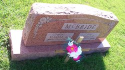

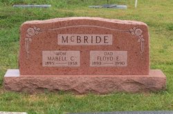
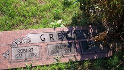
Floyd Earl McBride
| Birth | : | 8 May 1893 Kansas, USA |
| Death | : | 16 Aug 1990 Kansas, USA |
| Burial | : | Selby Cemetery, Selby, Selby District, England |
| Coordinate | : | 53.7766610, -1.0775960 |
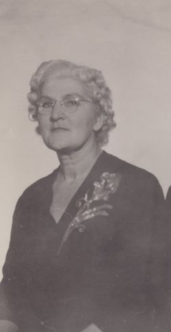
| Description | : | Floyd Earl McBride, 97, died Aug. 16, 1990. He was born May 8, 1893, at Mapleton, the son of Samuel and Hattie Bell Findley McBride. He married Mabell Caroline Collins Oct. 23, 1915, at Independence, Mo. She died March 3, 1958. He married Mary Post Cook in January 1959 at Fort Scott. She died April 1, 1973. He married Edith Coons May 3, 1977, at Mound City. Survivors include his wife, of the home; five sons, Charles Lewayne McBride, Samuel Dwight McBride, Floyd Leon McBride, Donald Lee McBride, and Kenneth Arthur McBride; two brothers, John... Read More |
frequently asked questions (FAQ):
-
Where is Floyd Earl McBride's memorial?
Floyd Earl McBride's memorial is located at: Selby Cemetery, Selby, Selby District, England.
-
When did Floyd Earl McBride death?
Floyd Earl McBride death on 16 Aug 1990 in Kansas, USA
-
Where are the coordinates of the Floyd Earl McBride's memorial?
Latitude: 53.7766610
Longitude: -1.0775960
Family Members:
Parent
Spouse
Siblings
Children
Flowers:


Nearby Cemetories:
1. Selby Cemetery
Selby, Selby District, England
Coordinate: 53.7766610, -1.0775960
2. St. Wilfrid's Parish Churchyard
Brayton, Selby District, England
Coordinate: 53.7718060, -1.0849010
3. Selby Abbey
Selby, Selby District, England
Coordinate: 53.7840990, -1.0670270
4. All Saints Churchyard
Barlby, Selby District, England
Coordinate: 53.7987840, -1.0415840
5. All Saints Churchyard
Wistow, Selby District, England
Coordinate: 53.8134750, -1.1014755
6. Hambleton Cemetery
Hambleton, Selby District, England
Coordinate: 53.7715910, -1.1624600
7. St Mary Churchyard
Hambleton, Selby District, England
Coordinate: 53.7715910, -1.1624600
8. St John The Baptist Churchyard
Chapel Haddlesey, Selby District, England
Coordinate: 53.7279200, -1.1185700
9. St. Mary's Churchyard
Riccall, Selby District, England
Coordinate: 53.8330620, -1.0601630
10. St Mary the Virgin Churchyard
Hemingbrough, Selby District, England
Coordinate: 53.7672100, -0.9796300
11. All Saints Churchyard
Cawood, Selby District, England
Coordinate: 53.8331970, -1.1235660
12. Rythergate Cemetery
Cawood, Selby District, England
Coordinate: 53.8356000, -1.1347700
13. Carlton Cemetery
Carlton, Selby District, England
Coordinate: 53.7129500, -1.0199200
14. Drax Cemetery
Drax, Selby District, England
Coordinate: 53.7272540, -0.9875330
15. St Mary Roman Catholic Church
Carlton, Selby District, England
Coordinate: 53.7111900, -1.0199300
16. St Mary Churchyard
Carlton, Selby District, England
Coordinate: 53.7088060, -1.0209800
17. St Peter and St Paul Churchyard
Drax, Selby District, England
Coordinate: 53.7293790, -0.9771560
18. Friends Burial Ground
Drax, Selby District, England
Coordinate: 53.7291640, -0.9771490
19. St. Helen's Churchyard
Skipwith, Selby District, England
Coordinate: 53.8386300, -1.0022900
20. St. Helen's Churchyard
Barmby on the Marsh, East Riding of Yorkshire Unitary Authority, England
Coordinate: 53.7476490, -0.9549090
21. St. Edmund's Churchyard
Kellington, Selby District, England
Coordinate: 53.7142600, -1.1710500
22. St Paul Churchyard
Hensall, Selby District, England
Coordinate: 53.6967500, -1.1185900
23. St Mary Churchyard
Birkin, Selby District, England
Coordinate: 53.7325000, -1.1979000
24. All Saints Churchyard
Ryther, Selby District, England
Coordinate: 53.8478600, -1.1576100