
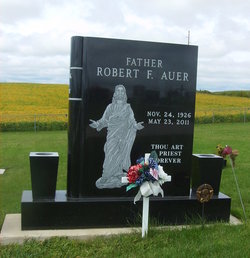
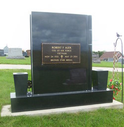
Fr Robert Francis Auer
| Birth | : | 24 Nov 1926 |
| Death | : | 23 May 2011 |
| Burial | : | Saint Joseph Cemetery, Garnavillo, Clayton County, USA |
| Coordinate | : | 42.8628006, -91.2502975 |
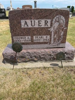
| Description | : | May 25, 2011 - Dubuque Telegraph Herald GUTTENBERG, Iowa -- Fr. Robert F. Auer, Chaplain Colonel USAF (Ret.), of Guttenberg, passed away Monday, May 23, 2011, at the Guttenberg Care Center. Services will be at 11 a.m. Friday, May 27, at St. Joseph's Catholic Church, Garnavillo, with the Rev. Marvin Bries officiating. Burial will be in St. Joseph's Cemetery, Garnavillo. Friends may call after 10 a.m. Friday at the church. The Tuecke-Allyn Funeral Home & Cremation Service, 001 S. Industrial Park Road, Garnavillo, is in charge of arrangements. He was born on Nov. 24, 1926, in Garnavillo, son of George and Pearl... Read More |
frequently asked questions (FAQ):
-
Where is Fr Robert Francis Auer's memorial?
Fr Robert Francis Auer's memorial is located at: Saint Joseph Cemetery, Garnavillo, Clayton County, USA.
-
When did Fr Robert Francis Auer death?
Fr Robert Francis Auer death on 23 May 2011 in
-
Where are the coordinates of the Fr Robert Francis Auer's memorial?
Latitude: 42.8628006
Longitude: -91.2502975
Family Members:
Parent

Siblings
Flowers:


Nearby Cemetories:
1. Saint Joseph Cemetery
Garnavillo, Clayton County, USA
Coordinate: 42.8628006, -91.2502975
2. Garnavillo Community Cemetery
Garnavillo, Clayton County, USA
Coordinate: 42.8656000, -91.2422100
3. Garnavillo Cemetery
Garnavillo, Clayton County, USA
Coordinate: 42.8660300, -91.2390100
4. McClelland Cemetery
Garnavillo, Clayton County, USA
Coordinate: 42.8249879, -91.2084641
5. Clayton Center Cemetery
Clayton Center, Clayton County, USA
Coordinate: 42.8841705, -91.3225021
6. Zion Lutheran Cemetery
Clayton Center, Clayton County, USA
Coordinate: 42.8841705, -91.3249969
7. Pioneer Rock Cemetery
Ceres, Clayton County, USA
Coordinate: 42.8230591, -91.1863937
8. Clayton Cemetery
Clayton, Clayton County, USA
Coordinate: 42.9043999, -91.1641998
9. Saint Michael Cemetery
Clayton County, USA
Coordinate: 42.8055992, -91.1802979
10. County Home Cemetery
Clayton Center, Clayton County, USA
Coordinate: 42.8916702, -91.3499985
11. Tangeman Family Cemetery
Garnavillo, Clayton County, USA
Coordinate: 42.8580000, -91.1420000
12. Krumm Cemetery
Garber, Clayton County, USA
Coordinate: 42.7913760, -91.3023559
13. Colony Catholic Cemetery (Defunct)
Read Township, Clayton County, USA
Coordinate: 42.8830000, -91.3580000
14. Borcherding Cemetery
Jefferson Township, Clayton County, USA
Coordinate: 42.8182983, -91.1414032
15. National Cemetery
National, Clayton County, USA
Coordinate: 42.9536018, -91.2902985
16. Meenan Cemetery
Communia, Clayton County, USA
Coordinate: 42.7999862, -91.3584693
17. Storck Cemetery
Guttenberg, Clayton County, USA
Coordinate: 42.7694335, -91.1834638
18. Saint Paula Cemetery
Osterdock, Clayton County, USA
Coordinate: 42.7635994, -91.1992035
19. Old Garber Cemetery
Garber, Clayton County, USA
Coordinate: 42.7560005, -91.2580032
20. Elkader Cemetery
Elkader, Clayton County, USA
Coordinate: 42.8541718, -91.4000015
21. Hartman Cemetery
Cox Creek Township, Clayton County, USA
Coordinate: 42.8155360, -91.3880840
22. Harford Cemetery
Wyalusing, Grant County, USA
Coordinate: 42.9401000, -91.1401800
23. Saint Josephs Cemetery
Elkader, Clayton County, USA
Coordinate: 42.8488998, -91.4021988
24. Communia Cemetery
Volga Township, Clayton County, USA
Coordinate: 42.7868996, -91.3630981