
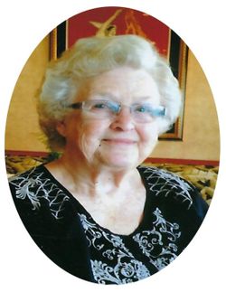
Patricia Louise “Pat” Auer Niehaus
| Birth | : | 11 Oct 1931 Garnavillo, Clayton County, Iowa, USA |
| Death | : | 21 Mar 2021 Guttenberg, Clayton County, Iowa, USA |
| Burial | : | Saint Joseph Cemetery, Garnavillo, Clayton County, USA |
| Coordinate | : | 42.8628006, -91.2502975 |
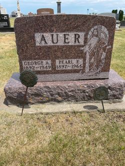
| Description | : | Patricia Niehaus, age 89, of Guttenberg, IA, died Sunday, March 21, 2021, at Guttenberg Care Center. She was born the daughter of George and Pearl (Chettinger) Auer on October 11, 1931 in Garnavillo, Iowa. On September 19, 1949 she was united in marriage with Robert Niehaus at St. Joseph’s Catholic Church in Garnavillo Iowa. Together they farmed for several years north of Garnavillo and were blessed with 4 children. Pat worked as the Secretary and Bookkeeper for... Read More |
frequently asked questions (FAQ):
-
Where is Patricia Louise “Pat” Auer Niehaus's memorial?
Patricia Louise “Pat” Auer Niehaus's memorial is located at: Saint Joseph Cemetery, Garnavillo, Clayton County, USA.
-
When did Patricia Louise “Pat” Auer Niehaus death?
Patricia Louise “Pat” Auer Niehaus death on 21 Mar 2021 in Guttenberg, Clayton County, Iowa, USA
-
Where are the coordinates of the Patricia Louise “Pat” Auer Niehaus's memorial?
Latitude: 42.8628006
Longitude: -91.2502975
Family Members:
Parent

Spouse
Siblings
Flowers:


Nearby Cemetories:
1. Saint Joseph Cemetery
Garnavillo, Clayton County, USA
Coordinate: 42.8628006, -91.2502975
2. Garnavillo Community Cemetery
Garnavillo, Clayton County, USA
Coordinate: 42.8656000, -91.2422100
3. Garnavillo Cemetery
Garnavillo, Clayton County, USA
Coordinate: 42.8660300, -91.2390100
4. McClelland Cemetery
Garnavillo, Clayton County, USA
Coordinate: 42.8249879, -91.2084641
5. Clayton Center Cemetery
Clayton Center, Clayton County, USA
Coordinate: 42.8841705, -91.3225021
6. Zion Lutheran Cemetery
Clayton Center, Clayton County, USA
Coordinate: 42.8841705, -91.3249969
7. Pioneer Rock Cemetery
Ceres, Clayton County, USA
Coordinate: 42.8230591, -91.1863937
8. Clayton Cemetery
Clayton, Clayton County, USA
Coordinate: 42.9043999, -91.1641998
9. Saint Michael Cemetery
Clayton County, USA
Coordinate: 42.8055992, -91.1802979
10. County Home Cemetery
Clayton Center, Clayton County, USA
Coordinate: 42.8916702, -91.3499985
11. Tangeman Family Cemetery
Garnavillo, Clayton County, USA
Coordinate: 42.8580000, -91.1420000
12. Krumm Cemetery
Garber, Clayton County, USA
Coordinate: 42.7913760, -91.3023559
13. Colony Catholic Cemetery (Defunct)
Read Township, Clayton County, USA
Coordinate: 42.8830000, -91.3580000
14. Borcherding Cemetery
Jefferson Township, Clayton County, USA
Coordinate: 42.8182983, -91.1414032
15. National Cemetery
National, Clayton County, USA
Coordinate: 42.9536018, -91.2902985
16. Meenan Cemetery
Communia, Clayton County, USA
Coordinate: 42.7999862, -91.3584693
17. Storck Cemetery
Guttenberg, Clayton County, USA
Coordinate: 42.7694335, -91.1834638
18. Saint Paula Cemetery
Osterdock, Clayton County, USA
Coordinate: 42.7635994, -91.1992035
19. Old Garber Cemetery
Garber, Clayton County, USA
Coordinate: 42.7560005, -91.2580032
20. Elkader Cemetery
Elkader, Clayton County, USA
Coordinate: 42.8541718, -91.4000015
21. Hartman Cemetery
Cox Creek Township, Clayton County, USA
Coordinate: 42.8155360, -91.3880840
22. Harford Cemetery
Wyalusing, Grant County, USA
Coordinate: 42.9401000, -91.1401800
23. Saint Josephs Cemetery
Elkader, Clayton County, USA
Coordinate: 42.8488998, -91.4021988
24. Communia Cemetery
Volga Township, Clayton County, USA
Coordinate: 42.7868996, -91.3630981