

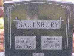
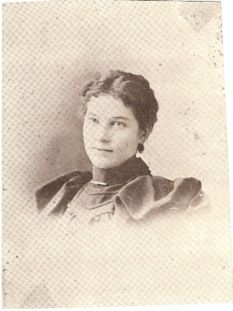
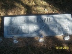
Frances Margaret “Fan” Saulsbury Gillespie
| Birth | : | 14 Mar 1906 Overton, Dawson County, Nebraska, USA |
| Death | : | 16 Apr 2002 Lexington, Dawson County, Nebraska, USA |
| Burial | : | St Michael and All Angels Churchyard, Twerton, Bath and North East Somerset Unitary Authority, England |
| Coordinate | : | 51.3809000, -2.3981000 |
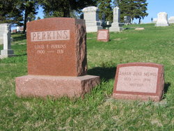
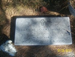
| Description | : | "Frances M. Gillespie, 96, of Lexington died Tuesday April 16, 2002 at Tri-county Hospital in Lexington. Services will be at 2 PM Friday at St. Ann's Catholic Church in Lexington with the Rev Don Buhrman officiating. Burial will be at the Robb Cemetery south of Lexington. She was born March 14, 1906, near Overton to Charles and Frances (Cooney) Saulsbury. She lived in the Overton and Lexington area all her life. On Dec 30 1950 she married Bill Gillespie in Cheyenne WY. She enjoyed cooking and traveling. " Fan and Lew Perkins had two children: Darlene Lou Perkins born 1924 died 2000 Charles... Read More |
frequently asked questions (FAQ):
-
Where is Frances Margaret “Fan” Saulsbury Gillespie's memorial?
Frances Margaret “Fan” Saulsbury Gillespie's memorial is located at: St Michael and All Angels Churchyard, Twerton, Bath and North East Somerset Unitary Authority, England.
-
When did Frances Margaret “Fan” Saulsbury Gillespie death?
Frances Margaret “Fan” Saulsbury Gillespie death on 16 Apr 2002 in Lexington, Dawson County, Nebraska, USA
-
Where are the coordinates of the Frances Margaret “Fan” Saulsbury Gillespie's memorial?
Latitude: 51.3809000
Longitude: -2.3981000
Family Members:
Parent
Spouse
Siblings
Children

Flowers:


Nearby Cemetories:
1. St Michael and All Angels Churchyard
Twerton, Bath and North East Somerset Unitary Authority, England
Coordinate: 51.3809000, -2.3981000
2. Locksbrook Cemetery
Lower Weston, Bath and North East Somerset Unitary Authority, England
Coordinate: 51.3845180, -2.3850300
3. Twerton Cemetery
Twerton, Bath and North East Somerset Unitary Authority, England
Coordinate: 51.3802500, -2.3836220
4. Locksbrook St Saviour's Cemetery
Bath and North East Somerset Unitary Authority, England
Coordinate: 51.3867880, -2.3863380
5. Haycombe Cemetery and Crematorium
Bath, Bath and North East Somerset Unitary Authority, England
Coordinate: 51.3703430, -2.4014760
6. St. Michael's Cemetery
Bath, Bath and North East Somerset Unitary Authority, England
Coordinate: 51.3859700, -2.3814500
7. Moravian Burial Ground
Bath, Bath and North East Somerset Unitary Authority, England
Coordinate: 51.3894150, -2.3798150
8. All Saints Churchyard
Weston, Bath and North East Somerset Unitary Authority, England
Coordinate: 51.3956850, -2.3881320
9. St. James' Cemetery
Bath, Bath and North East Somerset Unitary Authority, England
Coordinate: 51.3802000, -2.3722200
10. Countess of Huntingdon's Chapel
Walcot, Bath and North East Somerset Unitary Authority, England
Coordinate: 51.3967020, -2.3907434
11. St Peter Churchyard
Englishcombe, Bath and North East Somerset Unitary Authority, England
Coordinate: 51.3640600, -2.4088700
12. Holy Trinity Churchyard
Newton St Loe, Bath and North East Somerset Unitary Authority, England
Coordinate: 51.3820470, -2.4311300
13. St Mary's Chapel, Queens Square
Bath, Bath and North East Somerset Unitary Authority, England
Coordinate: 51.3827790, -2.3649790
14. St Mary Magdalen Chapel
Widcombe, Bath and North East Somerset Unitary Authority, England
Coordinate: 51.3760486, -2.3643405
15. Bath General Hospital Burial Ground
Bath and North East Somerset Unitary Authority, England
Coordinate: 51.3824715, -2.3614742
16. St James Old Burial Ground
Bath, Bath and North East Somerset Unitary Authority, England
Coordinate: 51.3798600, -2.3610100
17. Quaker Meeting House
Bath, Bath and North East Somerset Unitary Authority, England
Coordinate: 51.3823280, -2.3604380
18. St. Mary de Stall Churchyard (Defunct)
Bath, Bath and North East Somerset Unitary Authority, England
Coordinate: 51.3813350, -2.3600353
19. Ss Michael & Paul Churchyard
Bath, Bath and North East Somerset Unitary Authority, England
Coordinate: 51.3834970, -2.3596980
20. St. Michael's Burial Ground
Bath, Bath and North East Somerset Unitary Authority, England
Coordinate: 51.3838810, -2.3594090
21. Bath Abbey
Bath, Bath and North East Somerset Unitary Authority, England
Coordinate: 51.3815310, -2.3586640
22. Saint Mark's Churchyard
Widcombe, Bath and North East Somerset Unitary Authority, England
Coordinate: 51.3766660, -2.3588010
23. Old Orchard Street Catholic Burial Vault
Bath, Bath and North East Somerset Unitary Authority, England
Coordinate: 51.3800370, -2.3579910
24. St. Swithin Churchyard
Bath, Bath and North East Somerset Unitary Authority, England
Coordinate: 51.3885480, -2.3594500