
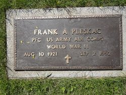
Frank Anton Pleskac
| Birth | : | 10 Aug 1924 Havre, Hill County, Montana, USA |
| Death | : | 2 Sep 1992 Great Falls, Cascade County, Montana, USA |
| Burial | : | Calvary Cemetery, Havre, Hill County, USA |
| Coordinate | : | 48.5457000, -109.6883000 |
| Plot | : | Spa 83 Block A 1 |
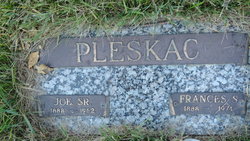
| Description | : | Obituary from Havre Daily News - 3 September 1992: Frank A. Pleskac, 71, died Wednesday morning at a Great Falls hospital following complications from open heart surgery. Funeral services are scheduled for Saturday at 10 a.m. at the First Lutheran Church with the Rev. Walt Kirkegaard officiating. Burial will be in the Calvary Cemetery. Mr. Pleskac was born Aug. 10,1921 in Havre to Joseph and Frances Stremcha Pleskac. He attended school in Havre and graduated from Havre High School. He was in World War II veteran serving with the United States Army Air Corp from 1942 to 1946. He served as a Utilities Tech with... Read More |
frequently asked questions (FAQ):
-
Where is Frank Anton Pleskac's memorial?
Frank Anton Pleskac's memorial is located at: Calvary Cemetery, Havre, Hill County, USA.
-
When did Frank Anton Pleskac death?
Frank Anton Pleskac death on 2 Sep 1992 in Great Falls, Cascade County, Montana, USA
-
Where are the coordinates of the Frank Anton Pleskac's memorial?
Latitude: 48.5457000
Longitude: -109.6883000
Family Members:
Parent

Spouse

Siblings
Flowers:


Nearby Cemetories:
1. Calvary Cemetery
Havre, Hill County, USA
Coordinate: 48.5457000, -109.6883000
2. Highland Cemetery
Havre, Hill County, USA
Coordinate: 48.5463982, -109.6900024
3. Mount Hope Cemetery
Havre, Hill County, USA
Coordinate: 48.5540000, -109.7050000
4. Sunset Garden Park
Havre, Hill County, USA
Coordinate: 48.5531006, -109.8019028
5. North Havre Lutheran Church Graveyard (Defunct)
Havre, Hill County, USA
Coordinate: 48.6538903, -109.6815870
6. Grainbelt Cemetery
Hill County, USA
Coordinate: 48.6828003, -109.8657990
7. Andrew S. Lohman Grave Site
Lohman, Blaine County, USA
Coordinate: 48.5903520, -109.4073350
8. East End Colony Cemetery
East End Colony, Hill County, USA
Coordinate: 48.7485000, -109.5474000
9. Hilldale Hutterite Colony Cemetery
Hilldale Colony, Hill County, USA
Coordinate: 48.7997000, -109.7872000
10. Saint Johns Catholic Cemetery
Havre, Hill County, USA
Coordinate: 48.7625008, -109.9638977
11. Saint Gabriel Cemetery
Chinook, Blaine County, USA
Coordinate: 48.6065200, -109.2531200
12. Kuper Memorial Cemetery
Chinook, Blaine County, USA
Coordinate: 48.6083100, -109.2531200
13. Rocky Boy Cemetery
Rocky Boy, Hill County, USA
Coordinate: 48.2572410, -109.7923690
14. Box Elder Cemetery
Box Elder, Hill County, USA
Coordinate: 48.3274000, -110.0095000
15. Rocky Boy Gravel Cemetery
Rocky Boy, Hill County, USA
Coordinate: 48.2427720, -109.7596500
16. Cottonwood Lutheran Church Cemetery
Havre, Hill County, USA
Coordinate: 48.4545000, -110.1748000
17. Bear Paw Battlefield
Chinook, Blaine County, USA
Coordinate: 48.3780070, -109.2121290
18. Hungry Hollow Cemetery
Blaine County, USA
Coordinate: 48.2103004, -109.4677963
19. Milk River Valley Church Graveyard
Hill County, USA
Coordinate: 48.6787180, -110.2261080
20. Hollandville Cemetery
Chinook, Blaine County, USA
Coordinate: 48.6960310, -109.1557200
21. Gildford Hill County Cemetery
Gildford, Hill County, USA
Coordinate: 48.5778008, -110.2957993
22. Prairie Chapel United Brethren Cemetery
Chinook, Blaine County, USA
Coordinate: 48.8860000, -109.3414000
23. Mennonite Brethren Cemetery
Chinook, Blaine County, USA
Coordinate: 48.8012560, -109.1980620
24. Bethel Bruderthaler Mennonite Church Cemetery
Chinook, Blaine County, USA
Coordinate: 48.7552000, -109.1345000