
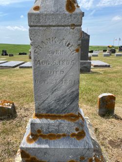
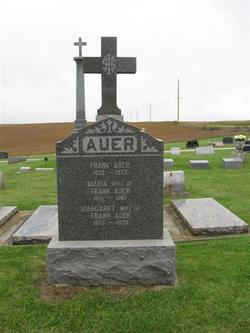
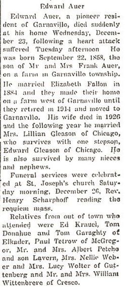
Frank Auer
| Birth | : | 5 Aug 1805 Bavaria (Bayern), Germany |
| Death | : | 27 Oct 1891 Garnavillo, Clayton County, Iowa, USA |
| Burial | : | Oak Grove Cemetery, Marion, McDowell County, USA |
| Coordinate | : | 35.6768990, -81.9966965 |
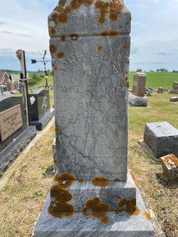
| Description | : | 1984 History of Clayton County, Iowa, pg. 25 Franz Sr. and Anna Auer Franz Auer Sr. b. 5 Aug. 1805 in Bavaria, Germany, and m. Anna (Clayton County records show three different maiden names for Anna! But believed to be Hochleitner) b. 6 April 1813 near Unterrohrn, Bavaria, Germany. Franz d. 27 Oct. 1891, Anna d. 28 Feb. 1884, buried in St. Joseph's Catholic Cemetery, Garnavillo. Because of a threatened revolution in Germany early in the 19th Century, Franz Sr. and Anna, with seven of their children (two b. in Clayton County), left their land near Lundshut, Bavaria, and emigrated to... Read More |
frequently asked questions (FAQ):
-
Where is Frank Auer's memorial?
Frank Auer's memorial is located at: Oak Grove Cemetery, Marion, McDowell County, USA.
-
When did Frank Auer death?
Frank Auer death on 27 Oct 1891 in Garnavillo, Clayton County, Iowa, USA
-
Where are the coordinates of the Frank Auer's memorial?
Latitude: 35.6768990
Longitude: -81.9966965
Family Members:
Spouse
Children
Flowers:


Nearby Cemetories:
1. Oak Grove Cemetery
Marion, McDowell County, USA
Coordinate: 35.6768990, -81.9966965
2. Morehead Cemetery
Marion, McDowell County, USA
Coordinate: 35.6787420, -81.9956450
3. Duncan Family Cemetery
Marion, McDowell County, USA
Coordinate: 35.6791540, -82.0011160
4. Saint John's Episcopal Church Columbarium
Marion, McDowell County, USA
Coordinate: 35.6793360, -82.0058020
5. Elhannon Cemetery
Marion, McDowell County, USA
Coordinate: 35.6861350, -81.9924160
6. Old Marion Methodist Episcopal Church Cemetery
McDowell County, USA
Coordinate: 35.6856260, -82.0063220
7. First United Methodist Church Columbarium
Marion, McDowell County, USA
Coordinate: 35.6917680, -82.0063040
8. Cross Mill Cemetery
Marion, McDowell County, USA
Coordinate: 35.6736341, -82.0221047
9. Chapel Hill Cemetery
Marion, McDowell County, USA
Coordinate: 35.6613998, -81.9756012
10. West Marion United Methodist Church Cemetery
Marion, McDowell County, USA
Coordinate: 35.6609920, -82.0235890
11. Redman Cemetery
McDowell County, USA
Coordinate: 35.7036170, -81.9832490
12. Barnes Cemetery
McDowell County, USA
Coordinate: 35.6567440, -81.9692870
13. McDowell Memorial Park
East Marion, McDowell County, USA
Coordinate: 35.7042007, -81.9775009
14. Solid Rock Free Will Baptist Church Cemetery
Marion, McDowell County, USA
Coordinate: 35.6693120, -81.9589280
15. Proctor-Henline Cemetery
Marion, McDowell County, USA
Coordinate: 35.7047030, -82.0192750
16. Pleasant Hill United Methodist Church Cemetery
Marion, McDowell County, USA
Coordinate: 35.6677690, -81.9572040
17. Mount Calvary Free Will Baptist Church Cemetery
McDowell County, USA
Coordinate: 35.6617550, -82.0401430
18. Murphys Chapel Cemetery
McDowell County, USA
Coordinate: 35.7086980, -81.9664990
19. Bethel Free Will Baptist Church Cemetery
Marion, McDowell County, USA
Coordinate: 35.7070920, -81.9578930
20. Marion Moose Family Center Memorial Garden
Nebo, McDowell County, USA
Coordinate: 35.7156600, -81.9712580
21. Ridgeway Freewill Baptist Church Cemetery
McDowell County, USA
Coordinate: 35.6319070, -82.0010530
22. Revis Cemetery
McDowell County, USA
Coordinate: 35.6753740, -81.9410790
23. Round Hill Baptist Church Cemetery
McDowell County, USA
Coordinate: 35.7050620, -82.0468440
24. Faith Mission Baptist Church Cemetery
McDowell County, USA
Coordinate: 35.6653820, -81.9352920