
| Birth | : | 7 Jun 1886 |
| Death | : | 22 Jun 1946 Cherokee County, Iowa, USA |
| Burial | : | Round Mound Cemetery, Cummings, Atchison County, USA |
| Coordinate | : | 39.4646988, -95.1908035 |
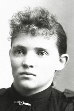
| Description | : | Frank Earl Cave, 60, passed away at his home at 435 East Cedar, Saturday, June 22, 1946, at 4:30 a.m. after a short illness. He was born June 7, 1886. Burial was in Afton cemetery. He has been a long time resident of Cherokee County, Iowa, farming near Cherokee and operating a dairy until ill health about 10 years ago forced him to sell his dairy and retire at Cherokee. Surviving are his widow and four children, Clarence of Cherokee, Iowa; Mrs. Harold Brownmiller of Aurelia, Iowa; Mrs. Leslie Gregg of Meriden, Iowa; and Mrs. Harold Raymond of Cleghorn,... Read More |
frequently asked questions (FAQ):
-
Where is Frank Earl Cave's memorial?
Frank Earl Cave's memorial is located at: Round Mound Cemetery, Cummings, Atchison County, USA.
-
When did Frank Earl Cave death?
Frank Earl Cave death on 22 Jun 1946 in Cherokee County, Iowa, USA
-
Where are the coordinates of the Frank Earl Cave's memorial?
Latitude: 39.4646988
Longitude: -95.1908035
Family Members:
Parent

Spouse
Siblings
Children
Flowers:


Nearby Cemetories:
1. Round Mound Cemetery
Cummings, Atchison County, USA
Coordinate: 39.4646988, -95.1908035
2. Ashcraft Cemetery
Saint Pats, Atchison County, USA
Coordinate: 39.4695396, -95.1479034
3. Springhill Cemetery
Potter, Atchison County, USA
Coordinate: 39.4303589, -95.2025375
4. Cummings District Cemetery
Cummings, Atchison County, USA
Coordinate: 39.4599609, -95.2416077
5. Mount Pleasant Cemetery
Potter, Atchison County, USA
Coordinate: 39.4520187, -95.1412964
6. Fairview Cemetery
Potter, Atchison County, USA
Coordinate: 39.4239006, -95.1613998
7. Saint Patrick Cemetery
Saint Pats, Atchison County, USA
Coordinate: 39.4689713, -95.1242523
8. Jackie Jones Cemetery
Cummings, Atchison County, USA
Coordinate: 39.4622000, -95.2631000
9. Old Young Cemetery
Potter, Atchison County, USA
Coordinate: 39.4480782, -95.1176071
10. Camp Creek Cemetery
Parnell, Atchison County, USA
Coordinate: 39.5202789, -95.2346573
11. Saint Johns Lutheran Cemetery
Millwood, Leavenworth County, USA
Coordinate: 39.4042015, -95.1386032
12. Pardee Cemetery
Cummings, Atchison County, USA
Coordinate: 39.4914589, -95.2860489
13. Mount Vernon Cemetery
Atchison, Atchison County, USA
Coordinate: 39.5383200, -95.1437800
14. Sumner Cemetery
Atchison, Atchison County, USA
Coordinate: 39.5163994, -95.1081009
15. Corpus Christi Cemetery
Winchester, Jefferson County, USA
Coordinate: 39.3908005, -95.2394028
16. Hays Cemetery
Oak Mills, Atchison County, USA
Coordinate: 39.4370300, -95.0883700
17. Griffin Cemetery
Cummings, Atchison County, USA
Coordinate: 39.4629707, -95.3053207
18. Heatherly Cemetery
Dalbey, Atchison County, USA
Coordinate: 39.4979000, -95.0829400
19. Yoakum Cemetery
Atchison, Atchison County, USA
Coordinate: 39.5522600, -95.1611400
20. Mormon Grove Historical Marker Memorial
Parnell, Atchison County, USA
Coordinate: 39.5572319, -95.1985931
21. Evergreen Cemetery
Millwood, Leavenworth County, USA
Coordinate: 39.3833008, -95.1333008
22. Lamar-Rogers Cemetery
Jefferson County, USA
Coordinate: 39.3867400, -95.2604900
23. Mount Gillin Cemetery
Port Williams, Atchison County, USA
Coordinate: 39.4598618, -95.0670776
24. Robinson Family Cemetery
Atchison, Atchison County, USA
Coordinate: 39.4920100, -95.3114700