
| Birth | : | 16 Jan 1856 Washington County, Ohio, USA |
| Death | : | 28 Jul 1930 Cherokee, Cherokee County, Iowa, USA |
| Burial | : | Knowle Green Congregational Graveyard, Knowle Green, Ribble Valley Borough, England |
| Coordinate | : | 53.8380170, -2.5507210 |
| Inscription | : | Mother |
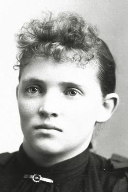
| Description | : | Martha Alice Ogle was born in Washington County, Ohio, January 16, 1856, and passed away at her home near Cherokee July 28, 1930, at the age of 74 years, six months and 12 days. At the age of two years, she came with her parents to Illinois where she spent her childhood years. In May, 1874, she was united in marriage to George Cave of Illinois. In 1878 the, with their family, emigrated overland from Illinois to Cherokee County, Iowa, and have continued to live in this county ever since, with the exception of... Read More |
frequently asked questions (FAQ):
-
Where is Martha Alice Ogle Cave's memorial?
Martha Alice Ogle Cave's memorial is located at: Knowle Green Congregational Graveyard, Knowle Green, Ribble Valley Borough, England.
-
When did Martha Alice Ogle Cave death?
Martha Alice Ogle Cave death on 28 Jul 1930 in Cherokee, Cherokee County, Iowa, USA
-
Where are the coordinates of the Martha Alice Ogle Cave's memorial?
Latitude: 53.8380170
Longitude: -2.5507210
Family Members:
Parent

Spouse
Siblings
Children
Flowers:


Nearby Cemetories:
1. Knowle Green Congregational Graveyard
Knowle Green, Ribble Valley Borough, England
Coordinate: 53.8380170, -2.5507210
2. The Church of St. Saviour The Holy House of Stydd
Ribchester, Ribble Valley Borough, England
Coordinate: 53.8188690, -2.5272770
3. St William of York Churchyard
Thornley with Wheatley, Ribble Valley Borough, England
Coordinate: 53.8559540, -2.5866660
4. St Wilfrid Churchyard
Ribchester, Ribble Valley Borough, England
Coordinate: 53.8102780, -2.5332650
5. St Lawrence Churchyard
Longridge, Ribble Valley Borough, England
Coordinate: 53.8252470, -2.6015030
6. St Wilfred Roman Catholic Churchyard Cemetery
Longridge, Ribble Valley Borough, England
Coordinate: 53.8317380, -2.6086060
7. St John the Evangelist Churchyard
Hurst Green, Ribble Valley Borough, England
Coordinate: 53.8358000, -2.4852530
8. Stonyhurst College Burial Ground
Hurst Green, Ribble Valley Borough, England
Coordinate: 53.8403420, -2.4840310
9. St. Joseph Roman Catholic Churchyard
Hurst Green, Ribble Valley Borough, England
Coordinate: 53.8409900, -2.4820600
10. Our Lady and St. Michael Roman Catholic Churchyard
Longridge, Ribble Valley Borough, England
Coordinate: 53.8088040, -2.6133470
11. Chipping Congregational Churchyard
Chipping, Ribble Valley Borough, England
Coordinate: 53.8836000, -2.5777700
12. St. Bartholomew Churchyard
Chipping, Ribble Valley Borough, England
Coordinate: 53.8846800, -2.5764100
13. St Leonard Churchyard
Balderstone, Ribble Valley Borough, England
Coordinate: 53.7860070, -2.5609380
14. St Mary's R.C. Church Cemetery
Osbaldeston, Ribble Valley Borough, England
Coordinate: 53.7816970, -2.5350240
15. Brockhall Hospital Cemetery
Brockhall Village, Ribble Valley Borough, England
Coordinate: 53.8186850, -2.4560220
16. St. Leonard Old Churchyard
Langho, Ribble Valley Borough, England
Coordinate: 53.8178590, -2.4552870
17. St Peter Churchyard
Salesbury, Ribble Valley Borough, England
Coordinate: 53.7915000, -2.4859100
18. St. Michael's Churchyard
Grimsargh, City of Preston, England
Coordinate: 53.7990710, -2.6352530
19. Mellor Methodist Churchyard
Blackburn, Blackburn with Darwen Unitary Authority, England
Coordinate: 53.7742950, -2.5255060
20. St. Mary's Churchyard
Mellor, Ribble Valley Borough, England
Coordinate: 53.7728600, -2.5312400
21. Whittingham Hospital Cemetery
Goosnargh, City of Preston, England
Coordinate: 53.8208401, -2.6613468
22. All Hallows Churchyard
Great Mitton, Ribble Valley Borough, England
Coordinate: 53.8461500, -2.4339000
23. Preston Crematorium
Preston, City of Preston, England
Coordinate: 53.7863750, -2.6340170
24. St. Mary the Virgin Churchyard
Goosnargh, City of Preston, England
Coordinate: 53.8266470, -2.6707030