
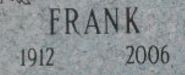

Frank J Simurdak
| Birth | : | 20 Dec 1912 Phillips, Price County, Wisconsin, USA |
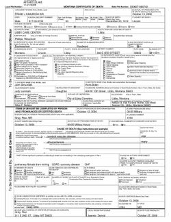
| Death | : | 12 Oct 2006 Libby, Lincoln County, Montana, USA |
| Burial | : | Pleasant View Cemetery, Athol, Smith County, USA |
| Coordinate | : | 39.7859000, -98.8982000 |
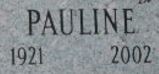
| Description | : | Frank Simurdak Posted: Wednesday, Oct 18, 2006 - 03:16:17 pm MDT Frank J. Simurdak, 93, a retired Libby businessman, died Thursday, Oct. 12, 2006, at Libby Care Center. Frank was born Dec. 20, 1912, in Phillips, Wis., to John and Anna Simurdiak and was raised and educated in Phillips. He worked in construction and came to Montana in the 1930s to work on the Fort Peck Dam project. Frank married the former Pauline Siegel on Aug. 24, 1939, in Reno, Nev. The couple in 1945 came to Libby, where they owned Gambles store in downtown Libby and then at Libby Shopping Center from 1965 until retiring... Read More |
frequently asked questions (FAQ):
-
Where is Frank J Simurdak's memorial?
Frank J Simurdak's memorial is located at: Pleasant View Cemetery, Athol, Smith County, USA.
-
When did Frank J Simurdak death?
Frank J Simurdak death on 12 Oct 2006 in Libby, Lincoln County, Montana, USA
-
Where are the coordinates of the Frank J Simurdak's memorial?
Latitude: 39.7859000
Longitude: -98.8982000
Family Members:
Spouse


Nearby Cemetories:
1. Pleasant View Cemetery
Athol, Smith County, USA
Coordinate: 39.7859000, -98.8982000
2. Saint John Lutheran Cemetery
Athol, Smith County, USA
Coordinate: 39.7269900, -98.8971600
3. Zion Cemetery
Athol, Smith County, USA
Coordinate: 39.8434100, -98.9171700
4. Meade Cemetery
Reamsville, Smith County, USA
Coordinate: 39.8680992, -98.8839035
5. Fairview Cemetery
Smith Center, Smith County, USA
Coordinate: 39.7966995, -98.7881012
6. Christ Cemetery
Gaylord, Smith County, USA
Coordinate: 39.6988100, -98.8556700
7. Saint John Lutheran Cemetery
Kensington, Smith County, USA
Coordinate: 39.7744700, -99.0308700
8. William Nelson Gravesite
Athol, Smith County, USA
Coordinate: 39.8866080, -98.8708130
9. Cedar Cemetery
Cedar, Smith County, USA
Coordinate: 39.6685982, -98.9310989
10. Germantown Cemetery
Kensington, Smith County, USA
Coordinate: 39.8292300, -99.0450800
11. Olive Branch Cemetery
Kensington, Smith County, USA
Coordinate: 39.7418800, -99.0470800
12. Gaylord Cemetery
Gaylord, Smith County, USA
Coordinate: 39.6598300, -98.8416700
13. Reamsville Methodist Church Cemetery
Reamsville, Smith County, USA
Coordinate: 39.9299500, -98.8693970
14. Reamsville Cemetery
Reamsville, Smith County, USA
Coordinate: 39.9441500, -98.8593500
15. Pleasant Hill Cemetery
Reamsville, Smith County, USA
Coordinate: 39.9510994, -98.9175034
16. Saint Francis Catholic Cemetery
Cedar, Smith County, USA
Coordinate: 39.6328011, -98.9816971
17. West Cedar Cemetery
Agra, Phillips County, USA
Coordinate: 39.8143997, -99.1136017
18. Eminence Cemetery
Thornburg, Smith County, USA
Coordinate: 39.9432983, -98.8005981
19. Agra Cemetery
Agra, Phillips County, USA
Coordinate: 39.7571600, -99.1220400
20. Spring Vale Cemetery
Washington Township, Smith County, USA
Coordinate: 39.9154700, -98.7424900
21. Fairview Stone Cemetery
Kensington, Smith County, USA
Coordinate: 39.9304330, -99.0479270
22. Custer Cemetery
Bellaire, Smith County, USA
Coordinate: 39.7350115, -98.6545141
23. Crystal Plains Cemetery
Smith Center, Smith County, USA
Coordinate: 39.6909714, -98.6730270
24. Old Harlan Cemetery
Harlan, Smith County, USA
Coordinate: 39.6153520, -98.7632390