
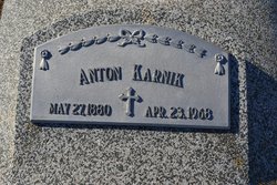
| Birth | : | 1 Jan 1844 |
| Death | : | 10 Oct 1923 |
| Burial | : | Riverview Cemetery, Saint Joseph, Berrien County, USA |
| Coordinate | : | 42.0657997, -86.4657974 |
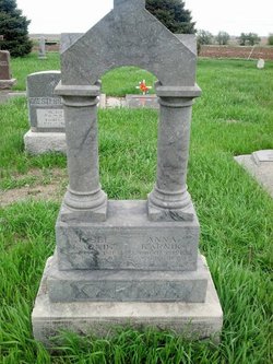
| Description | : | The following was found in a book at the Nebraska State Historical Society entitled "Bohemian Settlements In Nebraska" which appears to be a collection of translations of Bohemian newspaper articles, some cited, most not. Transcribed by Linda Berney: Reminiscences of Frank Karnik, Dodge, Nebraska - I came to Nebraska, to Fremont, October 1, 1877. Nowadays the trip is much shorter and pleasanter, it was not so then. The old pioneers were good hearted, they were willing to help others, although they had nothing themselves. We came to the farm of Ignac Vlasak, thirty miles northwest of Fremont.... Read More |
frequently asked questions (FAQ):
-
Where is Frank Karnik's memorial?
Frank Karnik's memorial is located at: Riverview Cemetery, Saint Joseph, Berrien County, USA.
-
When did Frank Karnik death?
Frank Karnik death on 10 Oct 1923 in
-
Where are the coordinates of the Frank Karnik's memorial?
Latitude: 42.0657997
Longitude: -86.4657974
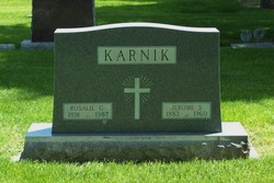
Family Members:
Parent

Spouse

Siblings
Children
Flowers:


Nearby Cemetories:
1. Riverview Cemetery
Saint Joseph, Berrien County, USA
Coordinate: 42.0657997, -86.4657974
2. Saint Joseph First UMC Memorial Garden
Saint Joseph, Berrien County, USA
Coordinate: 42.0810930, -86.4909620
3. Highland Cemetery
Saint Joseph, Berrien County, USA
Coordinate: 42.0650980, -86.4987150
4. First Congregational Church UCC Memorial Garden
Saint Joseph, Berrien County, USA
Coordinate: 42.0949790, -86.4842940
5. Hickory Bluff Cemetery
Stevensville, Berrien County, USA
Coordinate: 42.0398670, -86.4952000
6. Spring Run Cemetery
Scottdale, Berrien County, USA
Coordinate: 42.0407600, -86.4348526
7. Saint Joseph City Cemetery
Saint Joseph, Berrien County, USA
Coordinate: 42.0960090, -86.4905980
8. Jerome Cemetery
Saint Joseph, Berrien County, USA
Coordinate: 42.0302699, -86.4758279
9. Resurrection Cemetery
Saint Joseph, Berrien County, USA
Coordinate: 42.0975800, -86.4920883
10. Calvary Cemetery
Benton Harbor, Berrien County, USA
Coordinate: 42.0901820, -86.4196160
11. Temple Beth El Memorial Park
Berrien County, USA
Coordinate: 42.0908660, -86.4154530
12. Crystal Springs Cemetery
Benton Harbor, Berrien County, USA
Coordinate: 42.0918999, -86.4150009
13. B'nai Sholom Cemetery
Fair Plain, Berrien County, USA
Coordinate: 42.0938988, -86.4163971
14. Bethel Cemetery
Sodus, Berrien County, USA
Coordinate: 42.0652770, -86.4013880
15. Lincoln Charter Township Cemetery
Stevensville, Berrien County, USA
Coordinate: 42.0271490, -86.5139110
16. Morton Hill Cemetery
Benton Harbor, Berrien County, USA
Coordinate: 42.1194000, -86.4417038
17. Royalton Cemetery
Saint Joseph, Berrien County, USA
Coordinate: 42.0094365, -86.4249946
18. Pearl Cemetery
Benton Township, Berrien County, USA
Coordinate: 42.0905991, -86.3641968
19. Mount Pleasant Cemetery
Sodus Township, Berrien County, USA
Coordinate: 42.0194016, -86.3581009
20. Feather Cemetery
Hinchman, Berrien County, USA
Coordinate: 41.9720955, -86.4356689
21. Ruggles Cemetery
Baroda, Berrien County, USA
Coordinate: 41.9644012, -86.4906006
22. Shanghai Cemetery
Eau Claire, Berrien County, USA
Coordinate: 42.0378100, -86.3299300
23. Salem Cemetery
Oronoko Township, Berrien County, USA
Coordinate: 41.9644012, -86.4278030
24. Shanghai Memorial Cemetery
Eau Claire, Berrien County, USA
Coordinate: 42.0377560, -86.3288930