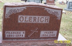
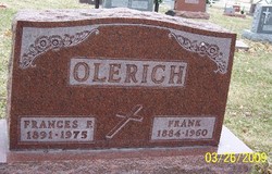
Frank Olerich
| Birth | : | 29 Nov 1884 Breda, Carroll County, Iowa, USA |
| Death | : | 18 Jan 1960 Carroll, Carroll County, Iowa, USA |
| Burial | : | Mount Hope Cemetery, Independence, Montgomery County, USA |
| Coordinate | : | 37.2413300, -95.7060050 |
| Description | : | Jan 20 1960 - Carroll Daily Times - Requiem mass will be at 9:30 a.m. Friday, Jan. 22, at St. Lawrence Church for Frank Olerich, 75, lifelong resident of Carroll County. The Rev. Robert Condon will officiate. Burial will be in Mt. Olivet Cemetery. The body is resting at the Twit Funeral Home, where friends may call starting at 7 p.m. Wednesday. The rosary will be recited at 8:30 p.m. Wednesday and again at 1 p.m. Thursday. Mr. Oierich died at 11 p.m. Monday, Jan. 18, at St. Anthony Hospital, after suffering a stroke. He had been ill three days. He... Read More |
frequently asked questions (FAQ):
-
Where is Frank Olerich's memorial?
Frank Olerich's memorial is located at: Mount Hope Cemetery, Independence, Montgomery County, USA.
-
When did Frank Olerich death?
Frank Olerich death on 18 Jan 1960 in Carroll, Carroll County, Iowa, USA
-
Where are the coordinates of the Frank Olerich's memorial?
Latitude: 37.2413300
Longitude: -95.7060050
Family Members:
Parent
Spouse
Siblings
Children
Flowers:
Nearby Cemetories:
1. Mount Hope Cemetery
Independence, Montgomery County, USA
Coordinate: 37.2413300, -95.7060050
2. Calvary Cemetery
Independence, Montgomery County, USA
Coordinate: 37.2486000, -95.7043991
3. Saint Andrews Cemetery
Independence, Montgomery County, USA
Coordinate: 37.2566986, -95.6658020
4. Pratt Cemetery
Montgomery County, USA
Coordinate: 37.2324982, -95.6557999
5. Le Hunt Cemetery
Montgomery County, USA
Coordinate: 37.2744300, -95.7586200
6. Radical Cemetery
Montgomery County, USA
Coordinate: 37.2882996, -95.7416992
7. Bethel Cemetery
Independence, Montgomery County, USA
Coordinate: 37.2761002, -95.6457977
8. Montgomery County Poor Farm Cemetery
Liberty, Montgomery County, USA
Coordinate: 37.1888590, -95.6493690
9. Choteau Cemetery
Independence, Montgomery County, USA
Coordinate: 37.3194700, -95.6746700
10. Harmony Cemetery
Cherryvale, Montgomery County, USA
Coordinate: 37.2324982, -95.5950012
11. Quaker Cemetery
Elk City, Montgomery County, USA
Coordinate: 37.2395900, -95.8243400
12. Thompson Homestead Cemetery
Liberty, Montgomery County, USA
Coordinate: 37.1767000, -95.6183100
13. Krone Cemetery
Montgomery County, USA
Coordinate: 37.3302400, -95.7494600
14. Highland Cemetery
Montgomery County, USA
Coordinate: 37.2092018, -95.8283005
15. Saint Francis Xavier Cemetery
Cherryvale, Montgomery County, USA
Coordinate: 37.2633018, -95.5753021
16. Liberty Cemetery
Liberty, Montgomery County, USA
Coordinate: 37.1581890, -95.6001580
17. Pleasant Dale Cemetery
Cherryvale, Montgomery County, USA
Coordinate: 37.3139700, -95.5860700
18. Parker Cemetery
Montgomery County, USA
Coordinate: 37.2630997, -95.8572006
19. Spring Hill Cemetery
Montgomery County, USA
Coordinate: 37.1235600, -95.6595500
20. Simpson Cemetery
Elk City, Montgomery County, USA
Coordinate: 37.3269005, -95.8186035
21. Centennial Cemetery
Cherryvale, Montgomery County, USA
Coordinate: 37.2296982, -95.5466995
22. Hinton Cemetery
Liberty, Montgomery County, USA
Coordinate: 37.1384900, -95.6101000
23. Spindletop Cemetery
Cherryvale, Montgomery County, USA
Coordinate: 37.2958400, -95.5570700
24. All Saints Cemetery
Liberty, Montgomery County, USA
Coordinate: 37.1542015, -95.5757980

