
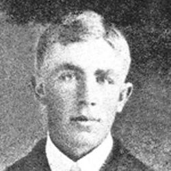
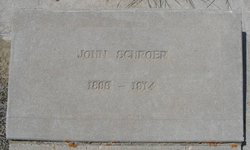
Frank Schroer
| Birth | : | 1 Sep 1886 Iowa, USA |
| Death | : | 7 Jul 1955 Lothair, Liberty County, Montana, USA |
| Burial | : | Lothair Catholic Cemetery, Lothair, Liberty County, USA |
| Coordinate | : | 48.4687000, -111.2484000 |
frequently asked questions (FAQ):
-
Where is Frank Schroer's memorial?
Frank Schroer's memorial is located at: Lothair Catholic Cemetery, Lothair, Liberty County, USA.
-
When did Frank Schroer death?
Frank Schroer death on 7 Jul 1955 in Lothair, Liberty County, Montana, USA
-
Where are the coordinates of the Frank Schroer's memorial?
Latitude: 48.4687000
Longitude: -111.2484000
Family Members:
Parent
Siblings

Flowers:


Nearby Cemetories:
1. Lothair Catholic Cemetery
Lothair, Liberty County, USA
Coordinate: 48.4687000, -111.2484000
2. Lothair Protestant Cemetery
Lothair, Liberty County, USA
Coordinate: 48.4694000, -111.2393100
3. Galata Cemetery
Toole County, USA
Coordinate: 48.4655991, -111.3349991
4. Devon Cemetery
Toole County, USA
Coordinate: 48.4693000, -111.4713000
5. Chester Cemetery
Chester, Liberty County, USA
Coordinate: 48.5219002, -110.9807968
6. Saint Olaf Lutheran Cemetery
Toole County, USA
Coordinate: 48.2479000, -111.3182000
7. Eagle Creek Colony Cemetery
Chester, Liberty County, USA
Coordinate: 48.6976000, -111.2011000
8. Omholt Cemetery
Toole County, USA
Coordinate: 48.3058014, -111.5346985
9. Erickson Cemetery
Liberty County, USA
Coordinate: 48.3143997, -110.9503021
10. Trinity Church Cemetery
Lothair, Liberty County, USA
Coordinate: 48.7263000, -111.2296000
11. Grandview Cemetery
Toole County, USA
Coordinate: 48.7265000, -111.3615000
12. Dunkirk Cemetery
Dunkirk, Toole County, USA
Coordinate: 48.4797810, -111.6761860
13. Camrose Colony Cemetery
Conrad, Pondera County, USA
Coordinate: 48.3092000, -111.6114000
14. Golden West Cemetery
Conrad, Pondera County, USA
Coordinate: 48.1906013, -111.4957962
15. Riverview Colony Cemetery
Riverview Colony, Liberty County, USA
Coordinate: 48.1762000, -111.0315000
16. Joplin Cemetery
Joplin, Liberty County, USA
Coordinate: 48.5576720, -110.7622930
17. Wolf Cemetery
Liberty County, USA
Coordinate: 48.1617620, -110.9984420
18. Inverness Cemetery
Hill County, USA
Coordinate: 48.5531340, -110.6688450
19. Old Indian Cemetery
Liberty County, USA
Coordinate: 48.8680992, -111.2585983
20. Mountain View Cemetery
Shelby, Toole County, USA
Coordinate: 48.5032200, -111.8675800
21. Gold Butte Cemetery
Toole County, USA
Coordinate: 48.8793983, -111.3966980
22. Valley View Cemetery
Shelby, Toole County, USA
Coordinate: 48.5190000, -111.8863000
23. Whitlash Cemetery
Liberty County, USA
Coordinate: 48.9085999, -111.2699966
24. Bethel Cemetery
Hill County, USA
Coordinate: 48.6685982, -110.6406021