
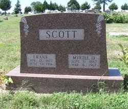
Frank Scott
| Birth | : | 12 Apr 1877 Concordia, Cloud County, Kansas, USA |
| Death | : | 14 Jun 1956 Concordia, Cloud County, Kansas, USA |
| Burial | : | Anfield Cemetery and Crematorium, Anfield, Metropolitan Borough of Liverpool, England |
| Coordinate | : | 53.4354680, -2.9578100 |
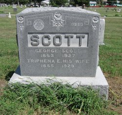
| Description | : | Frank Scott was born April 12, 1877 south of Concordia, the son of Mr. and Mrs. George Scott. He was a farmer in Center township about five miles south of Concordia and had spent his entire life in the community. At the time of his death he was farming within a mile of the home where he was born. On Nov. 29, 1905, he was married in Concordia to Myrtle Fudge. |
frequently asked questions (FAQ):
-
Where is Frank Scott's memorial?
Frank Scott's memorial is located at: Anfield Cemetery and Crematorium, Anfield, Metropolitan Borough of Liverpool, England.
-
When did Frank Scott death?
Frank Scott death on 14 Jun 1956 in Concordia, Cloud County, Kansas, USA
-
Where are the coordinates of the Frank Scott's memorial?
Latitude: 53.4354680
Longitude: -2.9578100
Family Members:
Parent

Spouse
Siblings
Children
Flowers:


Nearby Cemetories:
1. Anfield Cemetery and Crematorium
Anfield, Metropolitan Borough of Liverpool, England
Coordinate: 53.4354680, -2.9578100
2. St Luke Churchyard
Walton, Metropolitan Borough of Liverpool, England
Coordinate: 53.4396910, -2.9671400
3. St. Mary's Cemetery
Kirkdale, Metropolitan Borough of Liverpool, England
Coordinate: 53.4323690, -2.9752500
4. St Mary the Virgin Churchyard
Walton, Metropolitan Borough of Liverpool, England
Coordinate: 53.4464930, -2.9673330
5. St. George Churchyard
Everton, Metropolitan Borough of Liverpool, England
Coordinate: 53.4252810, -2.9713940
6. Kirkdale Goal Cemetery
Kirkdale, Metropolitan Borough of Liverpool, England
Coordinate: 53.4361110, -2.9802780
7. Rice Lane Jewish Cemetery
Walton, Metropolitan Borough of Liverpool, England
Coordinate: 53.4521700, -2.9590600
8. St. Anthony's Churchyard
Liverpool, Metropolitan Borough of Liverpool, England
Coordinate: 53.4223190, -2.9815350
9. Liverpool Necropolis
Everton, Metropolitan Borough of Liverpool, England
Coordinate: 53.4146670, -2.9621830
10. St. Alexander Church
Bootle, Metropolitan Borough of Sefton, England
Coordinate: 53.4401090, -2.9922250
11. Green Lane Jewish Cemetery
Liverpool, Metropolitan Borough of Liverpool, England
Coordinate: 53.4234720, -2.9280170
12. Everton Cemetery
Everton, Metropolitan Borough of Liverpool, England
Coordinate: 53.4555430, -2.9442480
13. Long Lane Jewish Cemetery
Liverpool, Metropolitan Borough of Liverpool, England
Coordinate: 53.4550140, -2.9420480
14. Walton Park Cemetery
Walton, Metropolitan Borough of Liverpool, England
Coordinate: 53.4564370, -2.9695960
15. St Martin-in-the-Fields Churchyard
Liverpool, Metropolitan Borough of Liverpool, England
Coordinate: 53.4210110, -2.9877860
16. St. Anne's Churchyard
Liverpool, Metropolitan Borough of Liverpool, England
Coordinate: 53.4149050, -2.9782840
17. Deane Road Cemetery
Liverpool, Metropolitan Borough of Liverpool, England
Coordinate: 53.4114570, -2.9460500
18. Brunswick Chapel
Liverpool, Metropolitan Borough of Liverpool, England
Coordinate: 53.4111280, -2.9675500
19. Holy Trinity Churchyard
Liverpool, Metropolitan Borough of Liverpool, England
Coordinate: 53.4117490, -2.9759560
20. Friends Burial Ground (Defunct)
Liverpool, Metropolitan Borough of Liverpool, England
Coordinate: 53.4111670, -2.9795830
21. Saint Anne Churchyard
Stanley, Metropolitan Borough of Liverpool, England
Coordinate: 53.4158800, -2.9238300
22. St. Mary's Churchyard
Edge Hill, Metropolitan Borough of Liverpool, England
Coordinate: 53.4065000, -2.9561600
23. St. Mary's Churchyard
Bootle, Metropolitan Borough of Sefton, England
Coordinate: 53.4492620, -3.0006520
24. West Derby Cemetery
West Derby, Metropolitan Borough of Liverpool, England
Coordinate: 53.4513790, -2.9154630