
Frank Thomas Ramsey
| Birth | : | 1 Mar 1927 Rutherford County, North Carolina, USA |
| Death | : | 9 Aug 1999 Asheville, Buncombe County, North Carolina, USA |
| Burial | : | Cooper Springs Congregational Holiness Church Ceme, Rutherford County, USA |
| Coordinate | : | 35.4755700, -81.7844540 |
frequently asked questions (FAQ):
-
Where is Frank Thomas Ramsey's memorial?
Frank Thomas Ramsey's memorial is located at: Cooper Springs Congregational Holiness Church Ceme, Rutherford County, USA.
-
When did Frank Thomas Ramsey death?
Frank Thomas Ramsey death on 9 Aug 1999 in Asheville, Buncombe County, North Carolina, USA
-
Where are the coordinates of the Frank Thomas Ramsey's memorial?
Latitude: 35.4755700
Longitude: -81.7844540
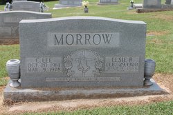
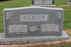
Family Members:
Parent
Spouse

Siblings

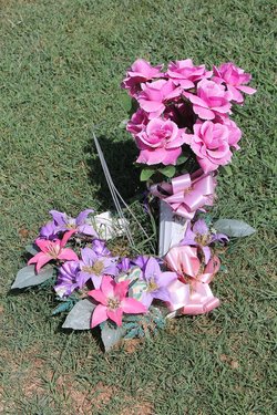
Flowers:


Nearby Cemetories:
1. Cooper Springs Congregational Holiness Church Ceme
Rutherford County, USA
Coordinate: 35.4755700, -81.7844540
2. Ross Hill Baptist Church Cemetery
Bostic, Rutherford County, USA
Coordinate: 35.4575280, -81.7922220
3. Mount Harmony Baptist Church Cemetery
Bostic, Rutherford County, USA
Coordinate: 35.4588380, -81.7996940
4. Golden Valley Missionary Methodist Church Cemetery
Bostic, Rutherford County, USA
Coordinate: 35.4961700, -81.7678800
5. Cedar Grove United Methodist Church Cemetery
Rutherford County, USA
Coordinate: 35.4506110, -81.8097540
6. Sweezy-Murray Family Cemetery
Rutherford County, USA
Coordinate: 35.4432090, -81.7671363
7. Fortune Cemetery
Rutherford County, USA
Coordinate: 35.5092010, -81.7647018
8. Golden Valley United Methodist Church Cemetery
Bostic, Rutherford County, USA
Coordinate: 35.5203018, -81.7900009
9. Duncans Creek Presbyterian Church Cemetery
Hollis, Rutherford County, USA
Coordinate: 35.4742680, -81.7276620
10. First Broad Baptist Church Cemetery
Bostic, Rutherford County, USA
Coordinate: 35.5176770, -81.7543960
11. Sunshine United Methodist Church Cemetery
Bostic, Rutherford County, USA
Coordinate: 35.4286930, -81.8132680
12. Mountain View Baptist Church Cemetery
Bostic, Rutherford County, USA
Coordinate: 35.4227630, -81.8080460
13. Price Family Cemetery
Hollis, Rutherford County, USA
Coordinate: 35.4548240, -81.7194440
14. Sandy Level Baptist Cemetery
Bostic, Rutherford County, USA
Coordinate: 35.4591400, -81.8520440
15. Mooney-Van Zandt Cemetery
Rutherford County, USA
Coordinate: 35.5335800, -81.7932500
16. Hollifield Family Cemetery
Bostic, Rutherford County, USA
Coordinate: 35.4203956, -81.8117291
17. Golden Valley Church of the Brethren Cemetery
Sunshine, Rutherford County, USA
Coordinate: 35.5368800, -81.7974200
18. Weast Cemetery
Sunshine, Rutherford County, USA
Coordinate: 35.5341320, -81.8145960
19. Mount Lebanon Cemetery
Rutherford County, USA
Coordinate: 35.4319000, -81.8414001
20. Fairview Church Cemetery
Forest City, Rutherford County, USA
Coordinate: 35.5409640, -81.8010940
21. Big Springs Baptist Cemetery
Hollis, Rutherford County, USA
Coordinate: 35.4366430, -81.7119510
22. Cane Creek Baptist Church Cemetery
Union Mills, Rutherford County, USA
Coordinate: 35.5222250, -81.8530630
23. Lees Chapel United Methodist Church Cemetery
Polkville, Cleveland County, USA
Coordinate: 35.4860764, -81.6936951
24. Wilson Baptist Cemetery
Forest City, Rutherford County, USA
Coordinate: 35.4257164, -81.8531723