
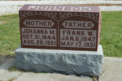
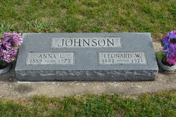
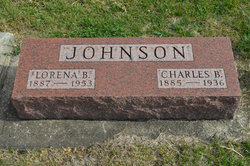
Frank Wilhelm Johnson
| Birth | : | 6 Jan 1847 Boxholms kommun, Östergötlands län, Sweden |
| Death | : | 17 May 1931 Hamilton County, Iowa, USA |
| Burial | : | South Marion Cemetery, Stratford, Hamilton County, USA |
| Coordinate | : | 42.2327995, -93.8735962 |
| Description | : | Stratford Courier May 21, 1931 FRANK W. JOHNSON Frank W. Johnson was born Jan. 6, 1847, at Åsbo Socken, Östergötland, Sweden and died May 17, 1934, at the age of 84 years, 4 months, 11 days. Funeral services were held yesterday afternoon with a short service at the home at 2 o'clock and at the Lutheran church at 2:30 conducted by the pastor, the Rev. Anton Chell. He used for his text Luke 2:29-30. At the home a duet was sung by Mrs. Martin Hall and Miss Ellen Anderson. At the church a quartet composed of Mrs. Hilder Anderson, Miss Hazel Barquist, Alfred Erickson... Read More |
frequently asked questions (FAQ):
-
Where is Frank Wilhelm Johnson's memorial?
Frank Wilhelm Johnson's memorial is located at: South Marion Cemetery, Stratford, Hamilton County, USA.
-
When did Frank Wilhelm Johnson death?
Frank Wilhelm Johnson death on 17 May 1931 in Hamilton County, Iowa, USA
-
Where are the coordinates of the Frank Wilhelm Johnson's memorial?
Latitude: 42.2327995
Longitude: -93.8735962
Family Members:
Spouse

Children
Flowers:


Nearby Cemetories:
1. South Marion Cemetery
Stratford, Hamilton County, USA
Coordinate: 42.2327995, -93.8735962
2. Oakwood Cemetery
Stratford, Hamilton County, USA
Coordinate: 42.2942009, -93.9182968
3. Mineral Ridge Cemetery
Ridgeport, Boone County, USA
Coordinate: 42.1749992, -93.9266968
4. Hooks Point Cemetery
Hamilton County, USA
Coordinate: 42.2944530, -93.9199090
5. Hardin Township Cemetery
Hardin Township, Webster County, USA
Coordinate: 42.2411003, -93.9708023
6. Saint Paul Lutheran Cemetery
Boone, Boone County, USA
Coordinate: 42.1700000, -93.8070000
7. Boone County Poor Farm Cemetery
Boone County, USA
Coordinate: 42.1591100, -93.9159000
8. White Cemetery
Boone County, USA
Coordinate: 42.1777992, -93.9636002
9. Lake Center Cemetery
Stanhope, Hamilton County, USA
Coordinate: 42.2482986, -93.7568970
10. Leininger Cemetery
Boone County, USA
Coordinate: 42.1492004, -93.8356018
11. Lawn Hill Cemetery
Stanhope, Hamilton County, USA
Coordinate: 42.2677994, -93.7611008
12. Nesse Cemetery
Hamilton County, USA
Coordinate: 42.3250008, -93.8933029
13. Neese Cemetery
Homer, Hamilton County, USA
Coordinate: 42.3250000, -93.8935000
14. Linn Cemetery
Pilot Mound, Boone County, USA
Coordinate: 42.2045330, -93.9970230
15. Vegors Cemetery
Webster County, USA
Coordinate: 42.3177986, -93.9421997
16. Mackey Cemetery
Boone County, USA
Coordinate: 42.1675000, -93.7565000
17. Runyan Cemetery
Pilot Mound, Boone County, USA
Coordinate: 42.1749992, -94.0015030
18. Saint Pauls Church Cemetery
Jewell, Hamilton County, USA
Coordinate: 42.2490100, -93.7173400
19. Schlicht Cemetery
Fraser, Boone County, USA
Coordinate: 42.1444200, -93.9780100
20. Bass Cemetery
Dayton, Webster County, USA
Coordinate: 42.2966995, -94.0149994
21. Saratoga Cemetery
Stanhope, Hamilton County, USA
Coordinate: 42.3539009, -93.8167038
22. Pilot Mound Cemetery
Pilot Mound, Boone County, USA
Coordinate: 42.1636200, -94.0282600
23. Ellsworth Clear Lake Cemetery
Randall, Hamilton County, USA
Coordinate: 42.2268930, -93.6926200
24. Bass Point Cemetery
Boone, Boone County, USA
Coordinate: 42.0992012, -93.8957977