

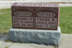
Johanna Mathilda Persdotter Johnson
| Birth | : | 31 Oct 1843 Vastra Harg, Mjölby kommun, Östergötlands län, Sweden |
| Death | : | 28 Aug 1921 Stratford, Hamilton County, Iowa, USA |
| Burial | : | South Marion Cemetery, Stratford, Hamilton County, USA |
| Coordinate | : | 42.2327995, -93.8735962 |
| Description | : | Stratford Courier September 8, 1921 Mrs. Johanna Mathilda Johnson, whose death was briefly mentioned in this paper last week, was born Oct. 31, 1844, in West Harg, Ostergotland, Sweden. Her death occured at noon of August 28, 1921, at the age of 76 years, 9 months, 27 days. February 13, 1873, she was united in marriage to Frank Wilhelm Johnson. Mr. Johnson came here from Sweden in 1880 and Mrs. Johnson and the three children who were born in Sweden came here the following year. They located in this community, living on farms in Webster and Hamilton Counties and moving into Stratford 14... Read More |
frequently asked questions (FAQ):
-
Where is Johanna Mathilda Persdotter Johnson's memorial?
Johanna Mathilda Persdotter Johnson's memorial is located at: South Marion Cemetery, Stratford, Hamilton County, USA.
-
When did Johanna Mathilda Persdotter Johnson death?
Johanna Mathilda Persdotter Johnson death on 28 Aug 1921 in Stratford, Hamilton County, Iowa, USA
-
Where are the coordinates of the Johanna Mathilda Persdotter Johnson's memorial?
Latitude: 42.2327995
Longitude: -93.8735962
Family Members:
Spouse
Children
Flowers:


Nearby Cemetories:
1. South Marion Cemetery
Stratford, Hamilton County, USA
Coordinate: 42.2327995, -93.8735962
2. Oakwood Cemetery
Stratford, Hamilton County, USA
Coordinate: 42.2942009, -93.9182968
3. Mineral Ridge Cemetery
Ridgeport, Boone County, USA
Coordinate: 42.1749992, -93.9266968
4. Hooks Point Cemetery
Hamilton County, USA
Coordinate: 42.2944530, -93.9199090
5. Hardin Township Cemetery
Hardin Township, Webster County, USA
Coordinate: 42.2411003, -93.9708023
6. Saint Paul Lutheran Cemetery
Boone, Boone County, USA
Coordinate: 42.1700000, -93.8070000
7. Boone County Poor Farm Cemetery
Boone County, USA
Coordinate: 42.1591100, -93.9159000
8. White Cemetery
Boone County, USA
Coordinate: 42.1777992, -93.9636002
9. Lake Center Cemetery
Stanhope, Hamilton County, USA
Coordinate: 42.2482986, -93.7568970
10. Leininger Cemetery
Boone County, USA
Coordinate: 42.1492004, -93.8356018
11. Lawn Hill Cemetery
Stanhope, Hamilton County, USA
Coordinate: 42.2677994, -93.7611008
12. Nesse Cemetery
Hamilton County, USA
Coordinate: 42.3250008, -93.8933029
13. Neese Cemetery
Homer, Hamilton County, USA
Coordinate: 42.3250000, -93.8935000
14. Linn Cemetery
Pilot Mound, Boone County, USA
Coordinate: 42.2045330, -93.9970230
15. Vegors Cemetery
Webster County, USA
Coordinate: 42.3177986, -93.9421997
16. Mackey Cemetery
Boone County, USA
Coordinate: 42.1675000, -93.7565000
17. Runyan Cemetery
Pilot Mound, Boone County, USA
Coordinate: 42.1749992, -94.0015030
18. Saint Pauls Church Cemetery
Jewell, Hamilton County, USA
Coordinate: 42.2490100, -93.7173400
19. Schlicht Cemetery
Fraser, Boone County, USA
Coordinate: 42.1444200, -93.9780100
20. Bass Cemetery
Dayton, Webster County, USA
Coordinate: 42.2966995, -94.0149994
21. Saratoga Cemetery
Stanhope, Hamilton County, USA
Coordinate: 42.3539009, -93.8167038
22. Pilot Mound Cemetery
Pilot Mound, Boone County, USA
Coordinate: 42.1636200, -94.0282600
23. Ellsworth Clear Lake Cemetery
Randall, Hamilton County, USA
Coordinate: 42.2268930, -93.6926200
24. Bass Point Cemetery
Boone, Boone County, USA
Coordinate: 42.0992012, -93.8957977