

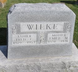
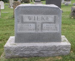
Frederick C.G. Wilke
| Birth | : | 7 Oct 1879 |
| Death | : | 29 Sep 1953 |
| Burial | : | Zion Lutheran Cemetery, Clayton Center, Clayton County, USA |
| Coordinate | : | 42.8841705, -91.3249969 |
| Description | : | Fred C. Wilke is another of the native sons of Clayton county who has achieved definite success in connection with agricultural operations, and he may well consider himself fortunate in his choice and stage of vocation, for he is the owner of one of the well improved and valuable farms of the county, is established in peace and. plenty and finds that in all respects his "lines are cast in pleasant places," for the further reinforcement is given him of having the confidence and good will of the people of the county which has represented his home from the time... Read More |
frequently asked questions (FAQ):
-
Where is Frederick C.G. Wilke's memorial?
Frederick C.G. Wilke's memorial is located at: Zion Lutheran Cemetery, Clayton Center, Clayton County, USA.
-
When did Frederick C.G. Wilke death?
Frederick C.G. Wilke death on 29 Sep 1953 in
-
Where are the coordinates of the Frederick C.G. Wilke's memorial?
Latitude: 42.8841705
Longitude: -91.3249969
Family Members:
Spouse
Children
Flowers:


Nearby Cemetories:
1. Zion Lutheran Cemetery
Clayton Center, Clayton County, USA
Coordinate: 42.8841705, -91.3249969
2. Clayton Center Cemetery
Clayton Center, Clayton County, USA
Coordinate: 42.8841705, -91.3225021
3. County Home Cemetery
Clayton Center, Clayton County, USA
Coordinate: 42.8916702, -91.3499985
4. Colony Catholic Cemetery (Defunct)
Read Township, Clayton County, USA
Coordinate: 42.8830000, -91.3580000
5. Saint Joseph Cemetery
Garnavillo, Clayton County, USA
Coordinate: 42.8628006, -91.2502975
6. Elkader Cemetery
Elkader, Clayton County, USA
Coordinate: 42.8541718, -91.4000015
7. Garnavillo Community Cemetery
Garnavillo, Clayton County, USA
Coordinate: 42.8656000, -91.2422100
8. Garnavillo Cemetery
Garnavillo, Clayton County, USA
Coordinate: 42.8660300, -91.2390100
9. Saint Josephs Cemetery
Elkader, Clayton County, USA
Coordinate: 42.8488998, -91.4021988
10. Farmersburg-Wagner Cemetery
Farmersburg, Clayton County, USA
Coordinate: 42.9481010, -91.3700027
11. National Cemetery
National, Clayton County, USA
Coordinate: 42.9536018, -91.2902985
12. Hartman Cemetery
Cox Creek Township, Clayton County, USA
Coordinate: 42.8155360, -91.3880840
13. Meenan Cemetery
Communia, Clayton County, USA
Coordinate: 42.7999862, -91.3584693
14. Norway Lutheran Church Cemetery
Saint Olaf, Clayton County, USA
Coordinate: 42.9352798, -91.4302826
15. Krumm Cemetery
Garber, Clayton County, USA
Coordinate: 42.7913760, -91.3023559
16. Bismark Cemetery
Farmersburg, Clayton County, USA
Coordinate: 42.9790000, -91.3500000
17. Patterson Pioneer Cemetery
Saint Olaf, Clayton County, USA
Coordinate: 42.9216000, -91.4489000
18. Communia Cemetery
Volga Township, Clayton County, USA
Coordinate: 42.7868996, -91.3630981
19. McClelland Cemetery
Garnavillo, Clayton County, USA
Coordinate: 42.8249879, -91.2084641
20. Weymouth Cemetery
Saint Olaf, Clayton County, USA
Coordinate: 42.9278799, -91.4583559
21. Giard Cemetery
Farmersburg, Clayton County, USA
Coordinate: 42.9933014, -91.3080978
22. Clark Family Cemetery
Beulah, Clayton County, USA
Coordinate: 42.9166505, -91.4751415
23. Wagner Township Cemetery
Saint Olaf, Clayton County, USA
Coordinate: 42.9519386, -91.4513931
24. Blanchaine Cemetery
Volga, Clayton County, USA
Coordinate: 42.7676210, -91.3389040