
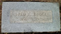
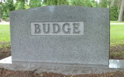
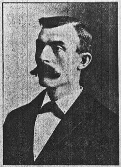
Frederick Granville “Fred” Budge
| Birth | : | 24 Oct 1896 |
| Death | : | 3 Apr 1970 Multnomah County, Oregon, USA |
| Burial | : | Calvary Baptist Cemetery, Cliffside, Rutherford County, USA |
| Coordinate | : | 35.2383995, -81.8110657 |
frequently asked questions (FAQ):
-
Where is Frederick Granville “Fred” Budge's memorial?
Frederick Granville “Fred” Budge's memorial is located at: Calvary Baptist Cemetery, Cliffside, Rutherford County, USA.
-
When did Frederick Granville “Fred” Budge death?
Frederick Granville “Fred” Budge death on 3 Apr 1970 in Multnomah County, Oregon, USA
-
Where are the coordinates of the Frederick Granville “Fred” Budge's memorial?
Latitude: 35.2383995
Longitude: -81.8110657
Family Members:
Parent
Siblings
Flowers:


Nearby Cemetories:
1. Calvary Baptist Cemetery
Cliffside, Rutherford County, USA
Coordinate: 35.2383995, -81.8110657
2. Goodes Creek Baptist Cemetery
Cliffside, Rutherford County, USA
Coordinate: 35.2307710, -81.8152780
3. New Zion Baptist Cemetery
Rutherford County, USA
Coordinate: 35.2595770, -81.8014850
4. Scruggs Cemetery
Rutherford County, USA
Coordinate: 35.2325800, -81.7814220
5. Rutherford County Memorial Cemetery
Forest City, Rutherford County, USA
Coordinate: 35.2463989, -81.8443985
6. Providence United Methodist Church Cemetery
Forest City, Rutherford County, USA
Coordinate: 35.2633018, -81.8305969
7. Floyd's Creek Baptist Church Cemetery
Forest City, Rutherford County, USA
Coordinate: 35.2386017, -81.8491974
8. Haynes Grove Cemetery
Cliffside, Rutherford County, USA
Coordinate: 35.2471930, -81.7735250
9. Camp Cemetery
Rutherford County, USA
Coordinate: 35.2061650, -81.8265550
10. Jerusalem Baptist Church Cemetery
Forest City, Rutherford County, USA
Coordinate: 35.2417000, -81.8553200
11. Cliffside Cemetery
Cliffside, Rutherford County, USA
Coordinate: 35.2460220, -81.7651250
12. High Shoal Baptist Cemetery
Henrietta, Rutherford County, USA
Coordinate: 35.2659800, -81.7777450
13. Caroleen Avondale Henrietta Cemetery
Avondale, Rutherford County, USA
Coordinate: 35.2753940, -81.7925690
14. Scruggs Cemetery
Cliffside, Rutherford County, USA
Coordinate: 35.2264000, -81.7639000
15. Trout Family Cemetery
Sandy Mush, Rutherford County, USA
Coordinate: 35.2762150, -81.8428660
16. Hopewell AME Zion Church Cemetery
Harris, Rutherford County, USA
Coordinate: 35.2426750, -81.8690230
17. Wesley Chapel Memorial Cemetery
Harris, Rutherford County, USA
Coordinate: 35.2369960, -81.8734430
18. Riverside Baptist Cemetery
Harris, Rutherford County, USA
Coordinate: 35.2128677, -81.8654327
19. Harris First Baptist Cemetery
Harris, Rutherford County, USA
Coordinate: 35.2428850, -81.8752240
20. Buck Shoals Baptist Cemetery
Rutherford County, USA
Coordinate: 35.1864100, -81.8266400
21. Old State Line Baptist Church Cemetery
Rutherford County, USA
Coordinate: 35.1834200, -81.8133400
22. New Bethel Baptist Cemetery
Forest City, Rutherford County, USA
Coordinate: 35.2505264, -81.8770294
23. Watkins Cemetery
Rutherford County, USA
Coordinate: 35.1946190, -81.7697410
24. John Matheny Family Cemetery
Mooresboro, Cleveland County, USA
Coordinate: 35.2492500, -81.7438310