
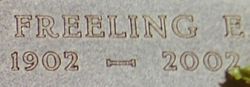
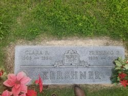
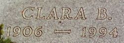
Freeling Eugene Kershner
| Birth | : | 17 Dec 1902 |
| Death | : | 1 Nov 2002 |
| Burial | : | Wheatley Lane Inghamite Church Churchyard, Wheatley Lane, Pendle Borough, England |
| Coordinate | : | 53.8412800, -2.2457100 |
| Description | : | Married: Jan 26, 1929 to Clara B. born Dec 17 1902 Died Nov. 1, 2002 Here is obituary: BURLINGAME -- Freeling E. Kershner, 99, Burlingame, died Friday, Nov. 1, 2002, at his home. Mr. Kershner farmed near Burlingame for many years and he and his wife managed the Osage County Home in Burlingame for more than 23 years. He was born Dec. 17, 1902, near Waverly, the son of Augustus Monroe and Stella Ophelia Brown Kershner. He attended school at Waverly. Mr. Kershner was a member of Grace Assembly in Burlingame. He married Clara B. Thornbrugh on Jan. 26, 1929, in Ottawa. She died... Read More |
frequently asked questions (FAQ):
-
Where is Freeling Eugene Kershner's memorial?
Freeling Eugene Kershner's memorial is located at: Wheatley Lane Inghamite Church Churchyard, Wheatley Lane, Pendle Borough, England.
-
When did Freeling Eugene Kershner death?
Freeling Eugene Kershner death on 1 Nov 2002 in
-
Where are the coordinates of the Freeling Eugene Kershner's memorial?
Latitude: 53.8412800
Longitude: -2.2457100
Family Members:
Spouse
Children
Flowers:


Nearby Cemetories:
1. Wheatley Lane Inghamite Church Churchyard
Wheatley Lane, Pendle Borough, England
Coordinate: 53.8412800, -2.2457100
2. All Souls Cemetery
Barrowford, Pendle Borough, England
Coordinate: 53.8462900, -2.2355600
3. Wheatley Lane Methodist Churchyard
Fence, Pendle Borough, England
Coordinate: 53.8341457, -2.2596202
4. St. Anne Churchyard
Fence, Pendle Borough, England
Coordinate: 53.8304372, -2.2679552
5. St. Mary's Churchyard
Newchurch in Pendle, Pendle Borough, England
Coordinate: 53.8504181, -2.2706807
6. St. Thomas Churchyard
Barrowford, Pendle Borough, England
Coordinate: 53.8513900, -2.2196600
7. St. Paul's Churchyard
Nelson, Pendle Borough, England
Coordinate: 53.8289250, -2.2157520
8. Barrowford Cemetery
Nelson, Pendle Borough, England
Coordinate: 53.8521100, -2.2130300
9. Marsden Friends Burial Ground
Marsden, Metropolitan Borough of Kirklees, England
Coordinate: 53.8241910, -2.2197410
10. Nelson Cemetery
Nelson, Pendle Borough, England
Coordinate: 53.8420330, -2.1972230
11. St. John the Evangelist Churchyard
Nelson, Pendle Borough, England
Coordinate: 53.8367000, -2.1977200
12. St John Churchyard
Higham, Pendle Borough, England
Coordinate: 53.8251420, -2.2898120
13. St. James' Churchyard
Briercliffe, Burnley Borough, England
Coordinate: 53.8107700, -2.2031800
14. Haggate Baptist Church Burial Ground
Burnley Borough, England
Coordinate: 53.8145048, -2.1960725
15. Hill Lane Baptist Church Churchyard
Briercliffe, Burnley Borough, England
Coordinate: 53.8161467, -2.1875368
16. Ebenezer Baptist Chapel Chapelyard
Burnley, Burnley Borough, England
Coordinate: 53.7975120, -2.2397260
17. St. Bartholomew Churchyard
Colne, Pendle Borough, England
Coordinate: 53.8570600, -2.1700470
18. West Street Inghamite Chapel Chapelyard
Colne, Pendle Borough, England
Coordinate: 53.8555930, -2.1672140
19. St. Peter's Churchyard
Burnley, Burnley Borough, England
Coordinate: 53.7924450, -2.2394890
20. John Ecroyd's Orchard
Lancaster, City of Lancaster, England
Coordinate: 53.8201990, -2.1697920
21. Twiston Quaker Burial Ground
Clitheroe, Ribble Valley Borough, England
Coordinate: 53.8854210, -2.2838840
22. St. James' Churchyard
Burnley, Burnley Borough, England
Coordinate: 53.7905590, -2.2458280
23. All Saints Churchyard
Habergham Eaves, Burnley Borough, England
Coordinate: 53.7971060, -2.2913770
24. Holy Trinity Churchyard
Burnley, Burnley Borough, England
Coordinate: 53.7898290, -2.2574200