
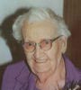

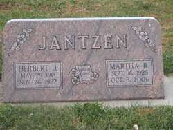
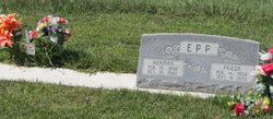
Frieda G. Jantzen Epp
| Birth | : | 14 Feb 1904 Plymouth, Jefferson County, Nebraska, USA |
| Death | : | 18 Sep 2005 Beatrice, Gage County, Nebraska, USA |
| Burial | : | St. Leonard's Churchyard, Padiham, Burnley Borough, England |
| Coordinate | : | 53.8022600, -2.3164300 |
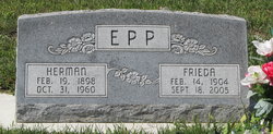
| Description | : | Frieda G. Epp, 101 years of age, of Beatrice, Nebraska, died Sunday morning, September 18, 2005 at the Beatrice Good Samaritan Center. She was born on February 14, 1904 at rural Plymouth, Nebraska. She attended country school District #38 near Plymouth, Nebraska, the German Bible School, and attended the Moody Bible Institute in Chicago, Illinois. She did baby-sitting for family, friends and neighbors prior to her marriage. On November 28, 1928 she married Herman Epp at the Kilpatrick church. They lived and farmed near Plymouth until 1955 and then moved to a farm near Fairbury. After the death of her... Read More |
frequently asked questions (FAQ):
-
Where is Frieda G. Jantzen Epp's memorial?
Frieda G. Jantzen Epp's memorial is located at: St. Leonard's Churchyard, Padiham, Burnley Borough, England.
-
When did Frieda G. Jantzen Epp death?
Frieda G. Jantzen Epp death on 18 Sep 2005 in Beatrice, Gage County, Nebraska, USA
-
Where are the coordinates of the Frieda G. Jantzen Epp's memorial?
Latitude: 53.8022600
Longitude: -2.3164300
Family Members:
Parent

Spouse
Siblings
Children
Flowers:


Nearby Cemetories:
1. St. Leonard's Churchyard
Padiham, Burnley Borough, England
Coordinate: 53.8022600, -2.3164300
2. Wesleyan Methodist Chapel Chapelyard
Padiham, Burnley Borough, England
Coordinate: 53.8018980, -2.3181730
3. St Leonard Churchyard Extension
Padiham, Burnley Borough, England
Coordinate: 53.7991800, -2.3222000
4. St. John's Cemetery
Padiham, Burnley Borough, England
Coordinate: 53.7948720, -2.3145290
5. All Saints Churchyard
Habergham Eaves, Burnley Borough, England
Coordinate: 53.7971060, -2.2913770
6. St James Church
Altham, Hyndburn Borough, England
Coordinate: 53.7928940, -2.3465250
7. St Margaret Churchyard
Hapton, Burnley Borough, England
Coordinate: 53.7802400, -2.3169230
8. St. John's Churchyard
Read, Ribble Valley Borough, England
Coordinate: 53.8088800, -2.3585600
9. St John Churchyard
Higham, Pendle Borough, England
Coordinate: 53.8251420, -2.2898120
10. Burnley Cemetery
Burnley, Burnley Borough, England
Coordinate: 53.7821730, -2.2795070
11. Burnley Crematorium
Burnley, Burnley Borough, England
Coordinate: 53.7821730, -2.2795070
12. Saint Nicholas Parish Churchyard
Sabden, Ribble Valley Borough, England
Coordinate: 53.8346503, -2.3332764
13. Holy Trinity Churchyard
Burnley, Burnley Borough, England
Coordinate: 53.7898290, -2.2574200
14. St Marys Burial Ground
Clayton-le-Moors, Hyndburn Borough, England
Coordinate: 53.7792778, -2.3705871
15. St. Anne Churchyard
Fence, Pendle Borough, England
Coordinate: 53.8304372, -2.2679552
16. St. James' Churchyard
Burnley, Burnley Borough, England
Coordinate: 53.7905590, -2.2458280
17. Accrington Cemetery and Crematorium
Accrington, Hyndburn Borough, England
Coordinate: 53.7623787, -2.3508649
18. Ebenezer Baptist Chapel Chapelyard
Burnley, Burnley Borough, England
Coordinate: 53.7975120, -2.2397260
19. Wheatley Lane Methodist Churchyard
Fence, Pendle Borough, England
Coordinate: 53.8341457, -2.2596202
20. St. Peter's Churchyard
Burnley, Burnley Borough, England
Coordinate: 53.7924450, -2.2394890
21. Barnes Square Weslyan Methodist Churchyard
Clayton-le-Moors, Hyndburn Borough, England
Coordinate: 53.7744350, -2.3853800
22. All Saints Churchyard
Clayton-le-Moors, Hyndburn Borough, England
Coordinate: 53.7738520, -2.3881690
23. Our Lady and Saint Hubert
Great Harwood, Hyndburn Borough, England
Coordinate: 53.7851070, -2.4009760
24. St. Bartholomew's Churchyard
Great Harwood, Hyndburn Borough, England
Coordinate: 53.7900670, -2.4055460