
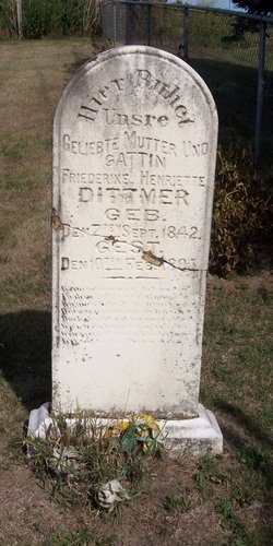
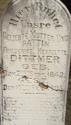
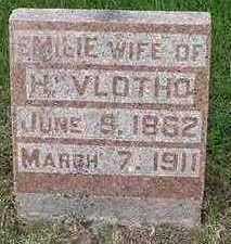
Friederike Henriette Rausch Dittmer
| Birth | : | 7 Sep 1842 Germany |
| Death | : | 10 Feb 1895 Clayton County, Iowa, USA |
| Burial | : | Saint Johns Cemetery, Jefferson Township, Clayton County, USA |
| Coordinate | : | 42.7497000, -91.1133000 |
| Inscription | : | Hier Ruhet Unsre GELIEBTE MUTTER UND GATTIN GEB. GEST. Here Lies Our Beloved Mother And Wife |
| Description | : | Freiderike H RAUSCH ..Native of Kingdom of Hanover d/o Johann Frederick RAUSCH & Marie Henriette ? ..Natives of Kingdom of Hanover ..Marie Freidr. Louise Henriette RAUSCH b.1842 married Guttenberg,IA.St.John.Lutheran.Church Gustav Fr. Wilh. DITTMER b.04SEP1835 Married 11NOV1859.Clayton.Co,IA Gustave F W DITTMER with consent of parents. Sibling of: - Chr.(Christian?) Freidr. RAUSCH c1834.GER- - L D RAUSCH (Brother) c1836.GER- - Chr. Freidr. RAUSCH c1840.GER- |
frequently asked questions (FAQ):
-
Where is Friederike Henriette Rausch Dittmer's memorial?
Friederike Henriette Rausch Dittmer's memorial is located at: Saint Johns Cemetery, Jefferson Township, Clayton County, USA.
-
When did Friederike Henriette Rausch Dittmer death?
Friederike Henriette Rausch Dittmer death on 10 Feb 1895 in Clayton County, Iowa, USA
-
Where are the coordinates of the Friederike Henriette Rausch Dittmer's memorial?
Latitude: 42.7497000
Longitude: -91.1133000
Family Members:
Parent

Spouse
Children
Flowers:


Nearby Cemetories:
1. Saint Johns Cemetery
Jefferson Township, Clayton County, USA
Coordinate: 42.7497000, -91.1133000
2. Guttenberg Cemetery
Guttenberg, Clayton County, USA
Coordinate: 42.7691994, -91.1035995
3. Saint Marys Cemetery
Guttenberg, Clayton County, USA
Coordinate: 42.7691994, -91.1352997
4. Mount Olivet Cemetery
Guttenberg, Clayton County, USA
Coordinate: 42.7764840, -91.1083560
5. Bierer Cemetery
Millville, Clayton County, USA
Coordinate: 42.7230500, -91.0925166
6. Redman Cemetery
Millville, Clayton County, USA
Coordinate: 42.7166755, -91.0852901
7. Friedlein Cemetery
Millville, Clayton County, USA
Coordinate: 42.7080994, -91.1108017
8. Lewis Cemetery
Osterdock, Clayton County, USA
Coordinate: 42.7416000, -91.1834000
9. Storck Cemetery
Guttenberg, Clayton County, USA
Coordinate: 42.7694335, -91.1834638
10. Bethel Cemetery
Osterdock, Clayton County, USA
Coordinate: 42.7041702, -91.1688919
11. Saint Paula Cemetery
Osterdock, Clayton County, USA
Coordinate: 42.7635994, -91.1992035
12. Graham Cemetery
Millville, Clayton County, USA
Coordinate: 42.6833172, -91.1195685
13. Old Saint Marys Cemetery
Glen Haven, Grant County, USA
Coordinate: 42.8078100, -91.0675330
14. Charlotte Cemetery
Glen Haven, Grant County, USA
Coordinate: 42.7933006, -91.0381012
15. Borcherding Cemetery
Jefferson Township, Clayton County, USA
Coordinate: 42.8182983, -91.1414032
16. Goshen Cemetery
Millville, Clayton County, USA
Coordinate: 42.6905594, -91.0544434
17. Saint Michael Cemetery
Clayton County, USA
Coordinate: 42.8055992, -91.1802979
18. Bolsinger Cemetery
Mallory Township, Clayton County, USA
Coordinate: 42.6776340, -91.1424090
19. Duncan Cemetery
Glen Haven, Grant County, USA
Coordinate: 42.8325540, -91.0725940
20. Pioneer Rock Cemetery
Ceres, Clayton County, USA
Coordinate: 42.8230591, -91.1863937
21. Ramsey Cemetery
North Andover, Grant County, USA
Coordinate: 42.7817001, -90.9972000
22. Gockel Cemetery
Glen Haven, Grant County, USA
Coordinate: 42.8224983, -91.0385971
23. Noggle Cemetery
Clayton County, USA
Coordinate: 42.6666580, -91.1654100
24. McClelland Cemetery
Garnavillo, Clayton County, USA
Coordinate: 42.8249879, -91.2084641