
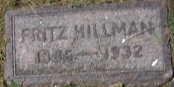
Fritz Dietrich John Hillman
| Birth | : | 31 Mar 1886 Otoe, Otoe County, Nebraska, USA |
| Death | : | 17 Aug 1932 Otoe, Otoe County, Nebraska, USA |
| Burial | : | All Saints Churchyard, Rangemore, East Staffordshire Borough, England |
| Coordinate | : | 52.8040800, -1.7337000 |
frequently asked questions (FAQ):
-
Where is Fritz Dietrich John Hillman's memorial?
Fritz Dietrich John Hillman's memorial is located at: All Saints Churchyard, Rangemore, East Staffordshire Borough, England.
-
When did Fritz Dietrich John Hillman death?
Fritz Dietrich John Hillman death on 17 Aug 1932 in Otoe, Otoe County, Nebraska, USA
-
Where are the coordinates of the Fritz Dietrich John Hillman's memorial?
Latitude: 52.8040800
Longitude: -1.7337000
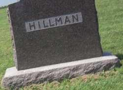
Family Members:
Spouse
Children

Flowers:


Nearby Cemetories:
1. All Saints Churchyard
Rangemore, East Staffordshire Borough, England
Coordinate: 52.8040800, -1.7337000
2. Holy Trinity Churchyard
Anslow, East Staffordshire Borough, England
Coordinate: 52.8216926, -1.7079807
3. St. Michael and All Angels Churchyard
Tatenhill, East Staffordshire Borough, England
Coordinate: 52.7958170, -1.6968150
4. St. Mary's Churchyard, Dunstall
Tatenhill, East Staffordshire Borough, England
Coordinate: 52.7809957, -1.7236464
5. Newchurch, Christchurch-in-Needwood
Hoar Cross, East Staffordshire Borough, England
Coordinate: 52.8083859, -1.7811304
6. Catholic Church of Saint Francis of Sales
Yoxall, East Staffordshire Borough, England
Coordinate: 52.7844140, -1.7909000
7. St. James' Churchyard
Barton-under-Needwood, East Staffordshire Borough, England
Coordinate: 52.7641321, -1.7228176
8. Saint Saviour's Cemetery
Burton upon Trent, East Staffordshire Borough, England
Coordinate: 52.7892907, -1.6668628
9. RAF Fauld
Hanbury, East Staffordshire Borough, England
Coordinate: 52.8474200, -1.7303500
10. St Werburgh's Church
Hanbury, East Staffordshire Borough, England
Coordinate: 52.8485000, -1.7478000
11. All Saints Churchyard
Newborough, East Staffordshire Borough, England
Coordinate: 52.8259013, -1.8003185
12. St. Peter's Churchyard
Yoxall, East Staffordshire Borough, England
Coordinate: 52.7687960, -1.7915250
13. The Holy Angels Churchyard
Hoar Cross, East Staffordshire Borough, England
Coordinate: 52.8047974, -1.8161691
14. St Laurence Churchyard
Walton-on-Trent, South Derbyshire District, England
Coordinate: 52.7613386, -1.6819775
15. Saint John the Divine Churchyard
Horninglow, East Staffordshire Borough, England
Coordinate: 52.8237520, -1.6426170
16. Rolleston Cemetery
Rolleston-on-Dove, East Staffordshire Borough, England
Coordinate: 52.8483757, -1.6643849
17. Priory Church of St. Mary the Virgin
Tutbury, East Staffordshire Borough, England
Coordinate: 52.8590900, -1.6877900
18. St Leonard's Church
Wychnor, East Staffordshire Borough, England
Coordinate: 52.7420071, -1.7394617
19. St Modwen Churchyard
Burton upon Trent, East Staffordshire Borough, England
Coordinate: 52.8013990, -1.6291340
20. Garden of Remembrance
Burton upon Trent, East Staffordshire Borough, England
Coordinate: 52.8023045, -1.6283625
21. St. Mary's Churchyard
Rolleston-on-Dove, East Staffordshire Borough, England
Coordinate: 52.8465144, -1.6519844
22. St. Paul's Churchyard Extension
Scropton, South Derbyshire District, England
Coordinate: 52.8687230, -1.7133750
23. St. Peter's Parish Churchyard
Stapenhill, East Staffordshire Borough, England
Coordinate: 52.7960899, -1.6230323
24. Stapenhill Cemetery
Burton upon Trent, East Staffordshire Borough, England
Coordinate: 52.8026310, -1.6208900