
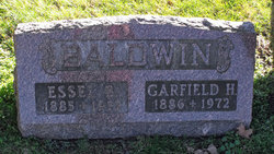
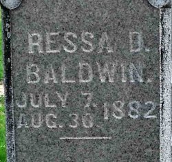
Garfield H. Baldwin
| Birth | : | 24 Jun 1886 Morrow County, Ohio, USA |
| Death | : | 14 Feb 1972 Ohio, USA |
| Burial | : | Witcher Cemetery, Belle, Kanawha County, USA |
| Coordinate | : | 38.2282982, -81.5093994 |
| Description | : | Son of Francis M. and Martha Elizabeth (James) Baldwin. Married 1st to Gertrude Foust. Married 2nd to Essel Bell Miller, daughter of T.W. and Matilda J. (Stacks) Miller. Married June 1942 in Morrow Cty., OH. She was previously married to Edward Geiser. |
frequently asked questions (FAQ):
-
Where is Garfield H. Baldwin's memorial?
Garfield H. Baldwin's memorial is located at: Witcher Cemetery, Belle, Kanawha County, USA.
-
When did Garfield H. Baldwin death?
Garfield H. Baldwin death on 14 Feb 1972 in Ohio, USA
-
Where are the coordinates of the Garfield H. Baldwin's memorial?
Latitude: 38.2282982
Longitude: -81.5093994
Family Members:
Parent

Spouse
Siblings

Flowers:


Nearby Cemetories:
1. Witcher Cemetery
Belle, Kanawha County, USA
Coordinate: 38.2282982, -81.5093994
2. Dickinson Cemetery (Defunct)
Kanawha County, USA
Coordinate: 38.2039300, -81.5018000
3. Nelson Cemetery
Chesapeake, Kanawha County, USA
Coordinate: 38.2263700, -81.5431700
4. Simmons Creek Community Cemetery
Belle, Kanawha County, USA
Coordinate: 38.2556200, -81.5214700
5. Gatewood Cemetery
Chelyan, Kanawha County, USA
Coordinate: 38.1941450, -81.4942650
6. Slaughters Creek Cemetery
Chelyan, Kanawha County, USA
Coordinate: 38.1896590, -81.4987280
7. Coalburg Cemetery
Coalburg, Kanawha County, USA
Coordinate: 38.2122640, -81.4539250
8. Dry Branch Cemetery
Dry Branch, Kanawha County, USA
Coordinate: 38.1814003, -81.4666977
9. Hensley Family Cemetery
Dry Branch, Kanawha County, USA
Coordinate: 38.1850014, -81.4574966
10. Clark Cemetery
Dry Branch, Kanawha County, USA
Coordinate: 38.1850320, -81.4567380
11. Virginia's Chapel Cemetery
Cedar Grove, Kanawha County, USA
Coordinate: 38.2176700, -81.4259900
12. Woodland Cemetery
Cedar Grove, Kanawha County, USA
Coordinate: 38.2182999, -81.4253006
13. Ward Cemetery
Cedar Grove, Kanawha County, USA
Coordinate: 38.2338982, -81.4175034
14. Ronda Cemetery
Cabin Creek, Kanawha County, USA
Coordinate: 38.1721590, -81.4491930
15. Parsons Cemetery
Alum Creek, Kanawha County, USA
Coordinate: 38.1660400, -81.4540700
16. Mount Lewis Cemetery
Cedar Grove, Kanawha County, USA
Coordinate: 38.2344017, -81.4124985
17. Stewart Family Cemetery
Coal Fork, Kanawha County, USA
Coordinate: 38.3069813, -81.4976488
18. Crown Hill Cemetery
Crown Hill, Kanawha County, USA
Coordinate: 38.1991700, -81.4134500
19. Blount Cemetery
Coal Fork, Kanawha County, USA
Coordinate: 38.3078100, -81.5354040
20. Younger Hollow Cemetery
Coal Fork, Kanawha County, USA
Coordinate: 38.3191986, -81.5333023
21. Belcher-White-Clay Cemetery
Blount, Kanawha County, USA
Coordinate: 38.3102250, -81.4264090
22. Comer Cemetery
Charleston, Kanawha County, USA
Coordinate: 38.2921701, -81.6152589
23. Garten Cemetery
Blount, Kanawha County, USA
Coordinate: 38.3138000, -81.4294400
24. Nunley Cemetery
Charleston, Kanawha County, USA
Coordinate: 38.3301000, -81.5573000